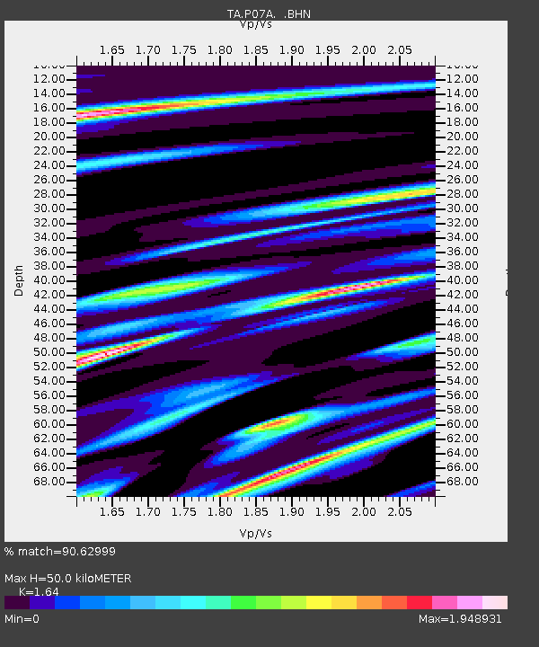
P07A Fallon, NV, USA - Earthquake Result Viewer
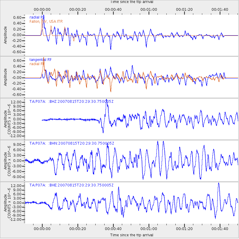
Earthquake location: Andreanof Islands, Aleutian Is.
Earthquake latitude/longitude: 50.3/-177.5
Earthquake time(UTC): 2007/08/15 (227) 20:22:11 GMT
Earthquake Depth: 9.0 km
Earthquake Magnitude: 6.3 MB, 6.2 MS, 6.4 MW, 5.9 ML
Earthquake Catalog/Contributor: WHDF/NEIC
Network: TA USArray Transportable Network (new EarthScope stations)
Station: P07A Fallon, NV, USA
Lat/Lon: 39.54 N/118.89 W
Elevation: 1219 m
Distance: 41.9 deg
Az: 81.582 deg
Baz: 304.913 deg
Ray Param: 0.07351092
Estimated Moho Depth: 50.0 km
Estimated Crust Vp/Vs: 1.64
Assumed Crust Vp: 6.279 km/s
Estimated Crust Vs: 3.828 km/s
Estimated Crust Poisson's Ratio: 0.20
Radial Match: 90.62999 %
Radial Bump: 400
Transverse Match: 78.79352 %
Transverse Bump: 400
SOD ConfigId: 2564
Insert Time: 2010-03-07 01:02:07.969 +0000
GWidth: 2.5
Max Bumps: 400
Tol: 0.001

Signal To Noise

ChannelStoNSTALTA
TA:P07A: :BHN:20070815T20:29:30.750005Z1.36330387.706549E-75.652848E-7
TA:P07A: :BHE:20070815T20:29:30.750005Z2.17674041.3620645E-66.257359E-7
TA:P07A: :BHZ:20070815T20:29:30.750005Z11.4523733.381612E-62.9527612E-7
Arrivals
Ps5.5 SECOND
PpPs20 SECOND
PsPs/PpSs25 SECOND