You are here: Home > Network List > TA - USArray Transportable Network (new EarthScope stations) Stations List
> Station P07A Fallon, NV, USA > Earthquake Result Viewer
P07A Fallon, NV, USA - Earthquake Result Viewer
| Earthquake location: |
Jujuy Province, Argentina |
| Earthquake latitude/longitude: |
-22.2/-65.8 |
| Earthquake time(UTC): |
2007/07/21 (202) 15:34:52 GMT |
| Earthquake Depth: |
290 km |
| Earthquake Magnitude: |
5.8 MB, 6.4 MW, 6.3 MW |
| Earthquake Catalog/Contributor: |
WHDF/NEIC |
|
| Network: |
TA USArray Transportable Network (new EarthScope stations) |
| Station: |
P07A Fallon, NV, USA |
| Lat/Lon: |
39.54 N/118.89 W |
| Elevation: |
1219 m |
|
| Distance: |
78.9 deg |
| Az: |
320.929 deg |
| Baz: |
130.919 deg |
| Ray Param: |
0.048560694 |
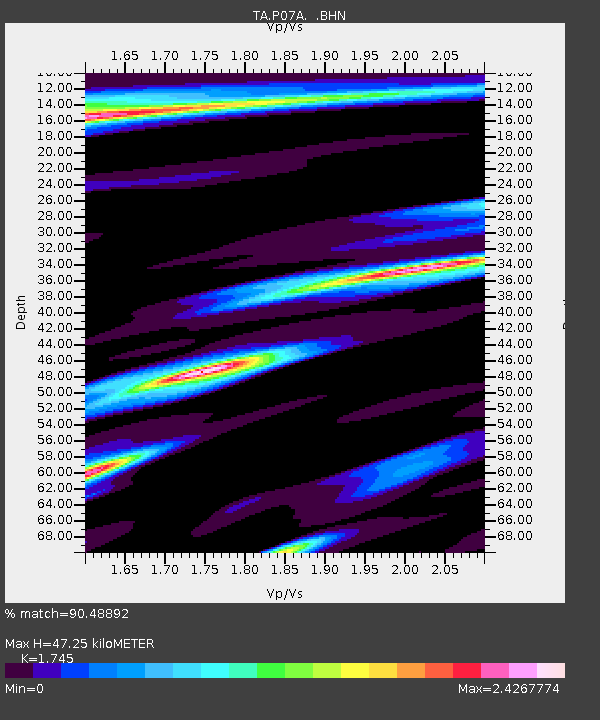
| Estimated Moho Depth: |
47.25 km |
| Estimated Crust Vp/Vs: |
1.75 |
| Assumed Crust Vp: |
6.279 km/s |
| Estimated Crust Vs: |
3.598 km/s |
| Estimated Crust Poisson's Ratio: |
0.26 |
|
| Radial Match: |
90.48892 % |
| Radial Bump: |
400 |
| Transverse Match: |
78.35207 % |
| Transverse Bump: |
400 |
| SOD ConfigId: |
2564 |
| Insert Time: |
2010-03-07 01:02:09.499 +0000 |
| GWidth: |
2.5 |
| Max Bumps: |
400 |
| Tol: |
0.001 |
|
Signal To Noise
| Channel | StoN | STA | LTA |
| TA:P07A: :BHN:20070721T15:45:52.975Z | 0.82070196 | 2.85364E-7 | 3.477072E-7 |
| TA:P07A: :BHE:20070721T15:45:52.975Z | 0.8575636 | 3.1750886E-7 | 3.702453E-7 |
| TA:P07A: :BHZ:20070721T15:45:52.975Z | 3.5966678 | 4.7599087E-7 | 1.323422E-7 |
| Arrivals |
| Ps | 5.8 SECOND |
| PpPs | 20 SECOND |
| PsPs/PpSs | 26 SECOND |


