You are here: Home > Network List > TA - USArray Transportable Network (new EarthScope stations) Stations List
> Station P07A Fallon, NV, USA > Earthquake Result Viewer
P07A Fallon, NV, USA - Earthquake Result Viewer
| Earthquake location: |
Near Coast Of Central Chile |
| Earthquake latitude/longitude: |
-32.0/-71.3 |
| Earthquake time(UTC): |
2007/06/28 (179) 19:25:21 GMT |
| Earthquake Depth: |
69 km |
| Earthquake Magnitude: |
5.5 MB, 5.7 MW, 5.6 MW |
| Earthquake Catalog/Contributor: |
WHDF/NEIC |
|
| Network: |
TA USArray Transportable Network (new EarthScope stations) |
| Station: |
P07A Fallon, NV, USA |
| Lat/Lon: |
39.54 N/118.89 W |
| Elevation: |
1219 m |
|
| Distance: |
83.7 deg |
| Az: |
324.971 deg |
| Baz: |
140.902 deg |
| Ray Param: |
0.045836322 |
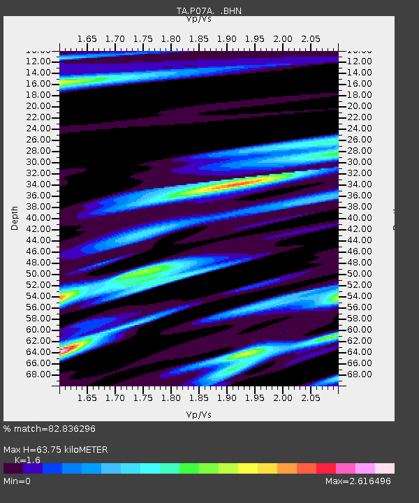
| Estimated Moho Depth: |
63.75 km |
| Estimated Crust Vp/Vs: |
1.60 |
| Assumed Crust Vp: |
6.279 km/s |
| Estimated Crust Vs: |
3.924 km/s |
| Estimated Crust Poisson's Ratio: |
0.18 |
|
| Radial Match: |
82.836296 % |
| Radial Bump: |
400 |
| Transverse Match: |
70.66568 % |
| Transverse Bump: |
400 |
| SOD ConfigId: |
2564 |
| Insert Time: |
2010-03-07 01:02:11.290 +0000 |
| GWidth: |
2.5 |
| Max Bumps: |
400 |
| Tol: |
0.001 |
|
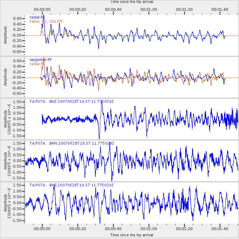
Signal To Noise
| Channel | StoN | STA | LTA |
| TA:P07A: :BHN:20070628T19:37:11.775029Z | 1.5810082 | 4.0657648E-7 | 2.5716278E-7 |
| TA:P07A: :BHE:20070628T19:37:11.775029Z | 2.2128735 | 5.3611205E-7 | 2.4226964E-7 |
| TA:P07A: :BHZ:20070628T19:37:11.775029Z | 5.423253 | 7.782261E-7 | 1.4349801E-7 |
| Arrivals |
| Ps | 6.3 SECOND |
| PpPs | 26 SECOND |
| PsPs/PpSs | 32 SECOND |


