You are here: Home > Network List > TA - USArray Transportable Network (new EarthScope stations) Stations List
> Station P07A Fallon, NV, USA > Earthquake Result Viewer
P07A Fallon, NV, USA - Earthquake Result Viewer
| Earthquake location: |
Tonga Islands |
| Earthquake latitude/longitude: |
-20.6/-174.0 |
| Earthquake time(UTC): |
2006/05/04 (124) 11:25:26 GMT |
| Earthquake Depth: |
11 km |
| Earthquake Magnitude: |
5.7 MB, 5.8 MS, 6.0 MW, 5.8 MW |
| Earthquake Catalog/Contributor: |
WHDF/NEIC |
|
| Network: |
TA USArray Transportable Network (new EarthScope stations) |
| Station: |
P07A Fallon, NV, USA |
| Lat/Lon: |
39.54 N/118.89 W |
| Elevation: |
1219 m |
|
| Distance: |
78.9 deg |
| Az: |
40.29 deg |
| Baz: |
231.586 deg |
| Ray Param: |
0.049325153 |
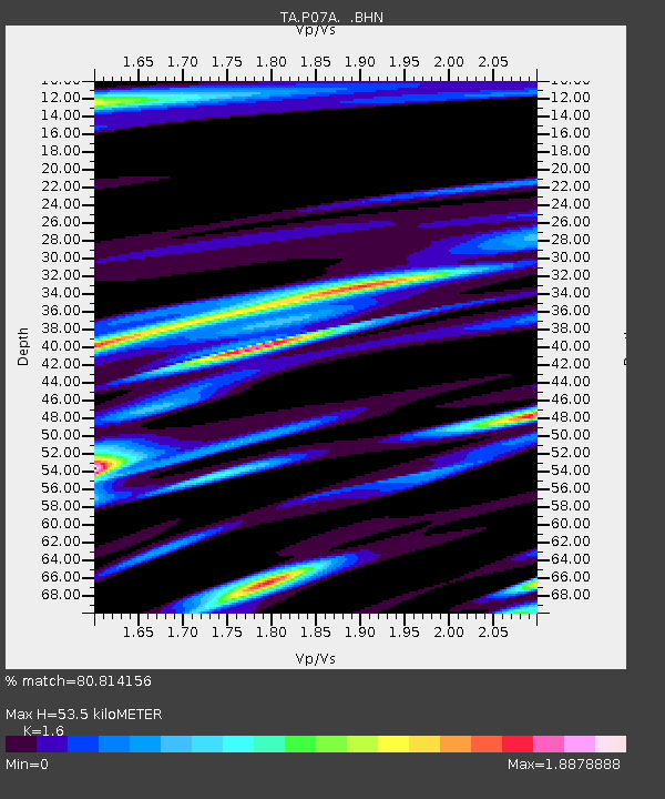
| Estimated Moho Depth: |
53.5 km |
| Estimated Crust Vp/Vs: |
1.60 |
| Assumed Crust Vp: |
6.279 km/s |
| Estimated Crust Vs: |
3.924 km/s |
| Estimated Crust Poisson's Ratio: |
0.18 |
|
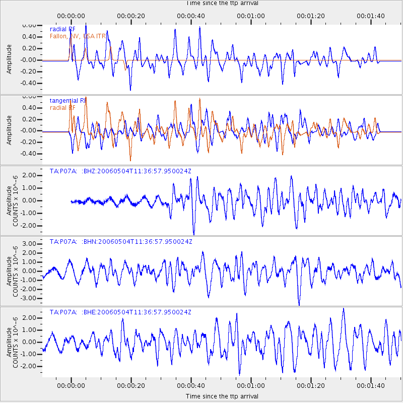
| Radial Match: |
80.814156 % |
| Radial Bump: |
400 |
| Transverse Match: |
73.33049 % |
| Transverse Bump: |
400 |
| SOD ConfigId: |
5423 |
| Insert Time: |
2010-03-07 01:02:17.861 +0000 |
| GWidth: |
2.5 |
| Max Bumps: |
400 |
| Tol: |
0.001 |
|
Signal To Noise
| Channel | StoN | STA | LTA |
| TA:P07A: :BHN:20060504T11:36:57.950024Z | 1.3476338 | 8.526854E-7 | 6.327278E-7 |
| TA:P07A: :BHE:20060504T11:36:57.950024Z | 1.2160614 | 3.6697207E-7 | 3.0177102E-7 |
| TA:P07A: :BHZ:20060504T11:36:57.950024Z | 3.2321882 | 6.210355E-7 | 1.9214089E-7 |
| Arrivals |
| Ps | 5.3 SECOND |
| PpPs | 21 SECOND |
| PsPs/PpSs | 27 SECOND |


