You are here: Home > Network List > TA - USArray Transportable Network (new EarthScope stations) Stations List
> Station P07A Fallon, NV, USA > Earthquake Result Viewer
P07A Fallon, NV, USA - Earthquake Result Viewer
| Earthquake location: |
Near Coast Of Peru |
| Earthquake latitude/longitude: |
-13.5/-76.7 |
| Earthquake time(UTC): |
2006/10/20 (293) 10:48:56 GMT |
| Earthquake Depth: |
23 km |
| Earthquake Magnitude: |
5.9 MB, 6.6 MS, 6.7 MW, 6.6 MW |
| Earthquake Catalog/Contributor: |
WHDF/NEIC |
|
| Network: |
TA USArray Transportable Network (new EarthScope stations) |
| Station: |
P07A Fallon, NV, USA |
| Lat/Lon: |
39.54 N/118.89 W |
| Elevation: |
1219 m |
|
| Distance: |
65.8 deg |
| Az: |
325.264 deg |
| Baz: |
134.202 deg |
| Ray Param: |
0.05803307 |
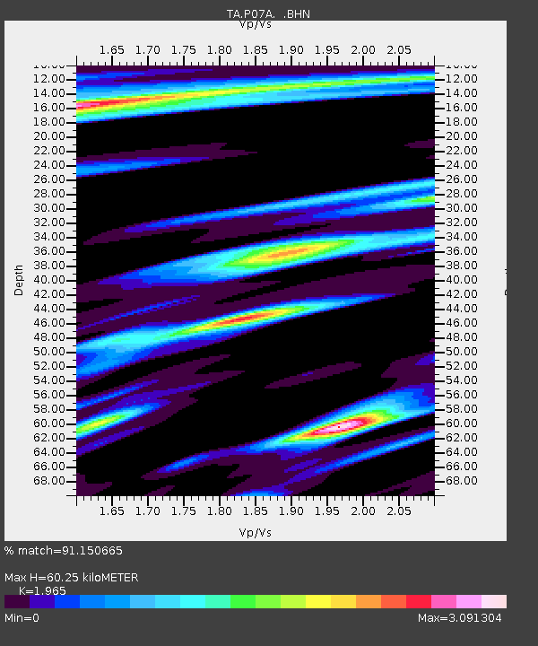
| Estimated Moho Depth: |
60.25 km |
| Estimated Crust Vp/Vs: |
1.97 |
| Assumed Crust Vp: |
6.279 km/s |
| Estimated Crust Vs: |
3.195 km/s |
| Estimated Crust Poisson's Ratio: |
0.33 |
|
| Radial Match: |
91.150665 % |
| Radial Bump: |
381 |
| Transverse Match: |
81.9896 % |
| Transverse Bump: |
400 |
| SOD ConfigId: |
2665 |
| Insert Time: |
2010-03-07 01:02:19.300 +0000 |
| GWidth: |
2.5 |
| Max Bumps: |
400 |
| Tol: |
0.001 |
|
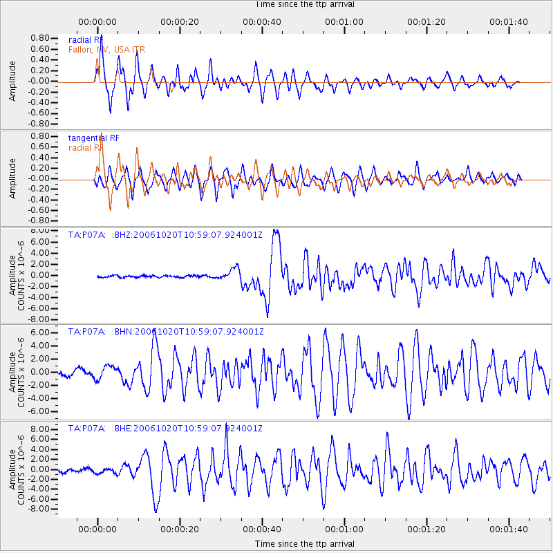
Signal To Noise
| Channel | StoN | STA | LTA |
| TA:P07A: :BHN:20061020T10:59:07.924001Z | 2.2269292 | 1.0054952E-6 | 4.5151646E-7 |
| TA:P07A: :BHE:20061020T10:59:07.924001Z | 1.2914276 | 5.0268346E-7 | 3.8924634E-7 |
| TA:P07A: :BHZ:20061020T10:59:07.924001Z | 6.779628 | 1.0936024E-6 | 1.6130714E-7 |
| Arrivals |
| Ps | 9.6 SECOND |
| PpPs | 27 SECOND |
| PsPs/PpSs | 37 SECOND |


