You are here: Home > Network List > TA - USArray Transportable Network (new EarthScope stations) Stations List
> Station P07A Fallon, NV, USA > Earthquake Result Viewer
P07A Fallon, NV, USA - Earthquake Result Viewer
| Earthquake location: |
San Juan Province, Argentina |
| Earthquake latitude/longitude: |
-31.7/-67.2 |
| Earthquake time(UTC): |
2006/09/17 (260) 09:34:14 GMT |
| Earthquake Depth: |
142 km |
| Earthquake Magnitude: |
5.7 MB, 6.2 MW, 6.2 MW |
| Earthquake Catalog/Contributor: |
WHDF/NEIC |
|
| Network: |
TA USArray Transportable Network (new EarthScope stations) |
| Station: |
P07A Fallon, NV, USA |
| Lat/Lon: |
39.54 N/118.89 W |
| Elevation: |
1219 m |
|
| Distance: |
85.6 deg |
| Az: |
322.502 deg |
| Baz: |
137.88 deg |
| Ray Param: |
0.04431133 |
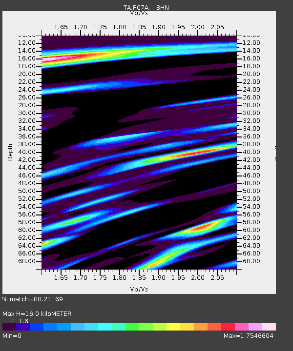
| Estimated Moho Depth: |
16.0 km |
| Estimated Crust Vp/Vs: |
1.60 |
| Assumed Crust Vp: |
6.279 km/s |
| Estimated Crust Vs: |
3.924 km/s |
| Estimated Crust Poisson's Ratio: |
0.18 |
|
| Radial Match: |
88.21169 % |
| Radial Bump: |
400 |
| Transverse Match: |
79.28935 % |
| Transverse Bump: |
400 |
| SOD ConfigId: |
2665 |
| Insert Time: |
2010-03-07 01:02:21.805 +0000 |
| GWidth: |
2.5 |
| Max Bumps: |
400 |
| Tol: |
0.001 |
|
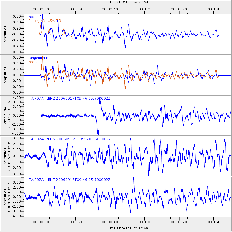
Signal To Noise
| Channel | StoN | STA | LTA |
| TA:P07A: :BHN:20060917T09:46:05.500002Z | 2.4615805 | 8.185463E-7 | 3.3252874E-7 |
| TA:P07A: :BHE:20060917T09:46:05.500002Z | 1.879443 | 7.757211E-7 | 4.1273987E-7 |
| TA:P07A: :BHZ:20060917T09:46:05.500002Z | 12.399658 | 2.069498E-6 | 1.668996E-7 |
| Arrivals |
| Ps | 1.6 SECOND |
| PpPs | 6.5 SECOND |
| PsPs/PpSs | 8.0 SECOND |


