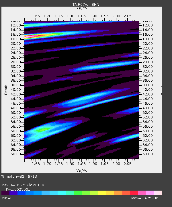
P07A Fallon, NV, USA - Earthquake Result Viewer
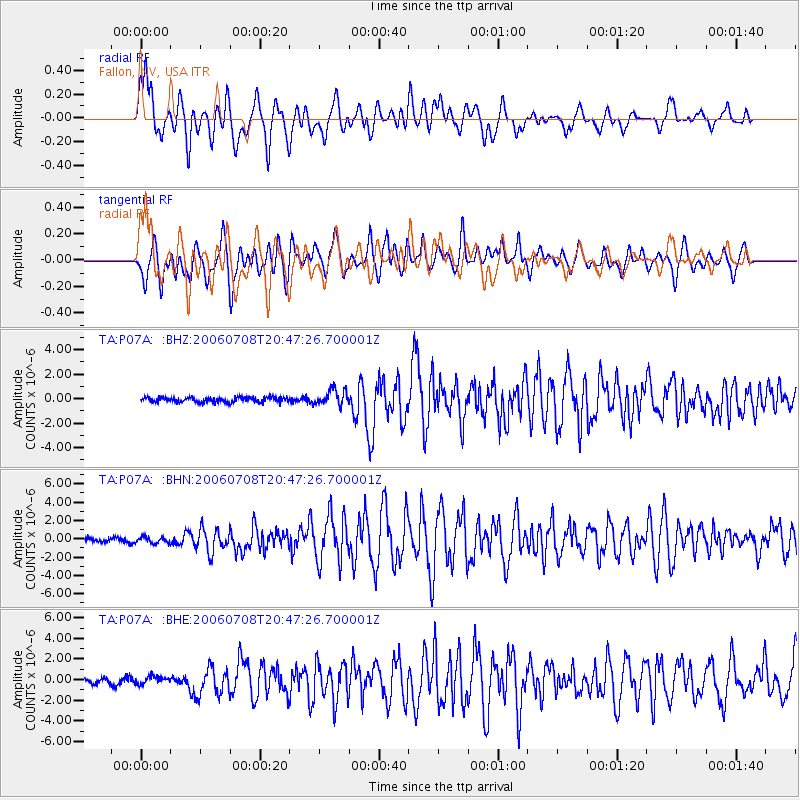
Earthquake location: Andreanof Islands, Aleutian Is.
Earthquake latitude/longitude: 51.2/-179.3
Earthquake time(UTC): 2006/07/08 (189) 20:40:00 GMT
Earthquake Depth: 22 km
Earthquake Magnitude: 6.2 MB, 6.4 MS, 6.6 MW, 6.6 MW
Earthquake Catalog/Contributor: WHDF/NEIC
Network: TA USArray Transportable Network (new EarthScope stations)
Station: P07A Fallon, NV, USA
Lat/Lon: 39.54 N/118.89 W
Elevation: 1219 m
Distance: 42.9 deg
Az: 81.369 deg
Baz: 306.47 deg
Ray Param: 0.072887465
Estimated Moho Depth: 16.75 km
Estimated Crust Vp/Vs: 1.60
Assumed Crust Vp: 6.279 km/s
Estimated Crust Vs: 3.918 km/s
Estimated Crust Poisson's Ratio: 0.18
Radial Match: 82.46713 %
Radial Bump: 400
Transverse Match: 69.667206 %
Transverse Bump: 400
SOD ConfigId: 2665
Insert Time: 2010-03-07 01:02:31.158 +0000
GWidth: 2.5
Max Bumps: 400
Tol: 0.001

Signal To Noise

ChannelStoNSTALTA
TA:P07A: :BHN:20060708T20:47:26.700001Z1.15875043.9949728E-73.447656E-7
TA:P07A: :BHE:20060708T20:47:26.700001Z1.04405843.7577834E-73.599208E-7
TA:P07A: :BHZ:20060708T20:47:26.700001Z3.2184266.430795E-71.998118E-7
Arrivals
Ps1.7 SECOND
PpPs6.5 SECOND
PsPs/PpSs8.2 SECOND