You are here: Home > Network List > TA - USArray Transportable Network (new EarthScope stations) Stations List
> Station Q03C Winters, CA, USA > Earthquake Result Viewer
Q03C Winters, CA, USA - Earthquake Result Viewer
| Earthquake location: |
Chile-Bolivia Border Region |
| Earthquake latitude/longitude: |
-22.3/-67.9 |
| Earthquake time(UTC): |
2005/11/17 (321) 19:26:56 GMT |
| Earthquake Depth: |
163 km |
| Earthquake Magnitude: |
6.0 MB, 6.9 MW, 6.8 MW |
| Earthquake Catalog/Contributor: |
WHDF/NEIC |
|
| Network: |
TA USArray Transportable Network (new EarthScope stations) |
| Station: |
Q03C Winters, CA, USA |
| Lat/Lon: |
38.63 N/122.01 W |
| Elevation: |
108 m |
|
| Distance: |
79.0 deg |
| Az: |
319.726 deg |
| Baz: |
130.156 deg |
| Ray Param: |
0.04883805 |
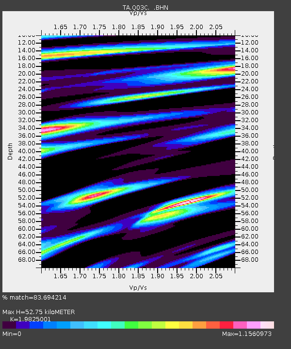
| Estimated Moho Depth: |
52.75 km |
| Estimated Crust Vp/Vs: |
1.98 |
| Assumed Crust Vp: |
6.472 km/s |
| Estimated Crust Vs: |
3.265 km/s |
| Estimated Crust Poisson's Ratio: |
0.33 |
|
| Radial Match: |
83.694214 % |
| Radial Bump: |
400 |
| Transverse Match: |
85.08751 % |
| Transverse Bump: |
400 |
| SOD ConfigId: |
2422 |
| Insert Time: |
2010-03-07 01:02:33.724 +0000 |
| GWidth: |
2.5 |
| Max Bumps: |
400 |
| Tol: |
0.001 |
|
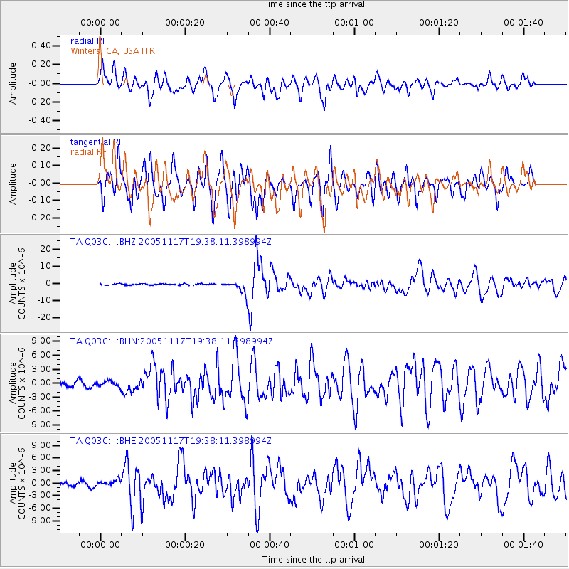
Signal To Noise
| Channel | StoN | STA | LTA |
| TA:Q03C: :BHN:20051117T19:38:11.398994Z | 0.8933994 | 5.797256E-7 | 6.488986E-7 |
| TA:Q03C: :BHE:20051117T19:38:11.398994Z | 1.2304869 | 7.475641E-7 | 6.0753524E-7 |
| TA:Q03C: :BHZ:20051117T19:38:11.398994Z | 11.729874 | 4.220323E-6 | 3.597927E-7 |
| Arrivals |
| Ps | 8.2 SECOND |
| PpPs | 24 SECOND |
| PsPs/PpSs | 32 SECOND |


