
Station TA Q03C - Winters, CA, USA
Network: TA - USArray Transportable Network (new EarthScope stations)
Nearby stations (2 deg radius)
| Station | Name | (Lat, Lon) | Start / End | Elevation |
| Q03C | Winters, CA, USA | (38.63, -122.01) | 2005-06-28 / 2499-01-01 | 108 m |
| Crust2 Type: | T6,Margin /shield transition, 1 km seds. |
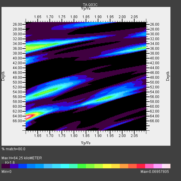
| Thickness Estimate: | 64 km |
| Thickness StdDev: | 6.7 km |
| Vp/Vs Estimate: | 1.60 |
| Vp/Vs StdDev: | 0.07 |
| Vs Estimate: | 4.045 km/s |
| Poisson's Ratio: | 0.18 |
| Peak Value: | 0.07 |
| Assumed Vp: | 6.472 km/s |
| Ps Weight: | 0.33333334 |
| PpPs Weight: | 0.33333334 |
| PsPs Weight: | 0.33333328 |
| Residual Complexity: | 0.789 |
| Nearby stations H: | +- |
| (2.0 deg) Vp/Vs: | +- |
1 with match > 90% ( 16.666666 %) and 6 with match > 80% ( 100.0 %) out of 6.
Download stack as xyz text file.
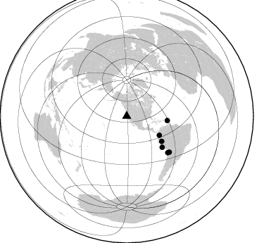
Azimuth Distribution of Events:
Prior Results for this Station
| Study | Thickness | Vp/Vs | Vp | Vs | Poissons Ratio | Extra |
| EARS | 64 km | 1.60 | 6.472 km/s | 4.045 km/s | 0.18 | |
| Crust2.0 | 32 km | 1.79 | 6.472 km/s | 3.622 km/s | 0.27 | T6,Margin /shield transition, 1 km seds. |
| Global Maxima | 64 km | 1.60 | 6.472 km/s | 4.045 km/s | 0.18 | amp=0.06957805 |
| Local Maxima 1 | 36 km | 1.64 | 6.472 km/s | 3.946 km/s | 0.20 | amp=0.04088401 |
| Local Maxima 2 | 54 km | 1.68 | 6.472 km/s | 3.858 km/s | 0.22 | amp=0.03685477 |
| Local Maxima 3 | 35 km | 1.60 | 6.472 km/s | 4.045 km/s | 0.18 | amp=0.029429806 |
| Local Maxima 4 | 56 km | 1.94 | 6.472 km/s | 3.34 km/s | 0.32 | amp=0.028437153 |
| Predicted Arrivals for vertical incidence (zero ray parameter) | |
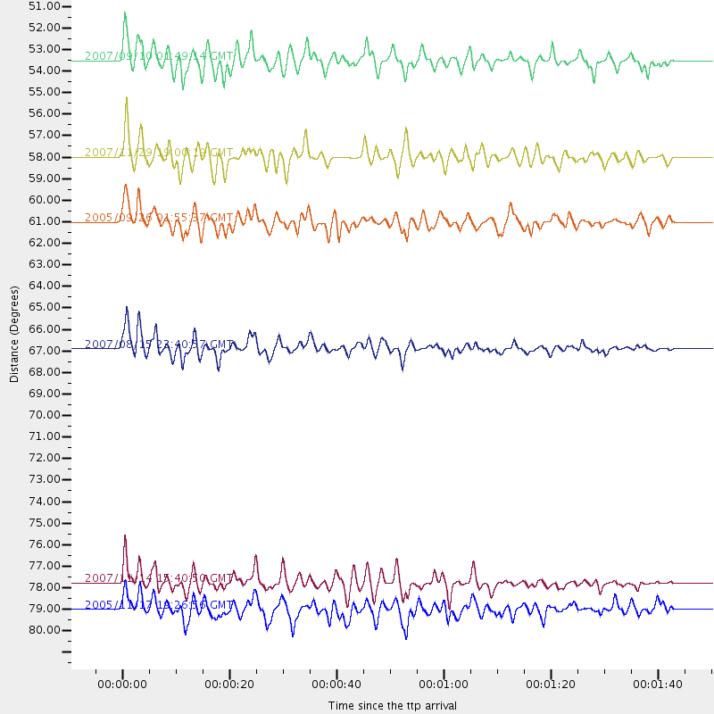
| Ps | 5.96 SECOND |
| PpPs | 25.81 SECOND |
| PsPs/PpSs | 31.77 SECOND |
Events Processed for this Station
Download zip of receiver functions as SAC
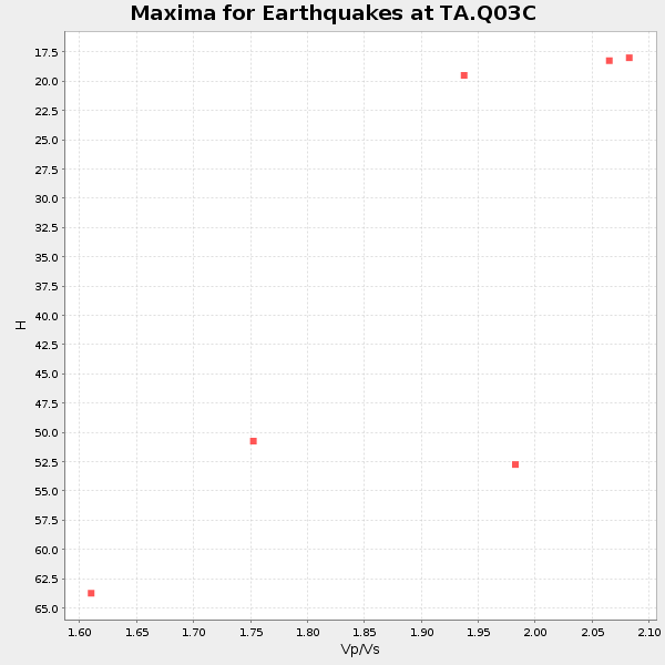
Plot maxima for each earthquake.
Events Used in the Stack
(6 events)| Radial Match | Distance | Baz | FERegion | Time | Lat/Lon | Depth | Magnitude |
| 92.09409 | 77.8 deg | 131.565 deg | Northern Chile | 2007/11/14 15:40:50 GMT | (-22.2, -69.9) | 40 km | 6.7 MB, 7.4 MS, 7.7 MW, 7.4 ME |
| 88.86339 | 61.0 deg | 125.632 deg | Northern Peru | 2005/09/26 01:55:37 GMT | (-5.7, -76.4) | 115 km | 6.7 MB, 7.5 MW, 7.5 MW |
| 87.78228 | 58.0 deg | 96.262 deg | Windward Islands | 2007/11/29 19:00:19 GMT | (15.0, -61.3) | 148 km | 6.9 MB, 7.4 MW, 7.4 MW |
| 84.48572 | 66.9 deg | 131.117 deg | Near Coast Of Peru | 2007/08/15 23:40:57 GMT | (-13.4, -76.6) | 39 km | 6.7 MB, 7.9 MS, 8.0 MW, 7.5 ME |
| 83.694214 | 79.0 deg | 130.156 deg | Chile-Bolivia Border Region | 2005/11/17 19:26:56 GMT | (-22.3, -67.9) | 163 km | 6.0 MB, 6.9 MW, 6.8 MW |
| 82.853676 | 53.5 deg | 120.307 deg | Near West Coast Of Colombia | 2007/09/10 01:49:14 GMT | (3.0, -78.0) | 31 km | 6.1 MB, 6.7 MS, 6.8 MW |
Losers
(0 events)| Radial Match | Distance | Baz | FERegion | Time | Lat/Lon | Depth | Magnitude | Reason |
