You are here: Home > Network List > TA - USArray Transportable Network (new EarthScope stations) Stations List
> Station Q03C Winters, CA, USA > Earthquake Result Viewer
Q03C Winters, CA, USA - Earthquake Result Viewer

| Earthquake location: |
Northern Peru |
| Earthquake latitude/longitude: |
-5.7/-76.4 |
| Earthquake time(UTC): |
2005/09/26 (269) 01:55:37 GMT |
| Earthquake Depth: |
115 km |
| Earthquake Magnitude: |
6.7 MB, 7.5 MW, 7.5 MW |
| Earthquake Catalog/Contributor: |
WHDF/NEIC |
|
| Network: |
TA USArray Transportable Network (new EarthScope stations) |
| Station: |
Q03C Winters, CA, USA |
| Lat/Lon: |
38.63 N/122.01 W |
| Elevation: |
108 m |
|
| Distance: |
61.0 deg |
| Az: |
320.233 deg |
| Baz: |
125.632 deg |
| Ray Param: |
0.06079773 |
| Estimated Moho Depth: |
18.25 km |
| Estimated Crust Vp/Vs: |
2.07 |
| Assumed Crust Vp: |
6.472 km/s |
| Estimated Crust Vs: |
3.134 km/s |
| Estimated Crust Poisson's Ratio: |
0.35 |
|
| Radial Match: |
88.86339 % |
| Radial Bump: |
400 |
| Transverse Match: |
84.27537 % |
| Transverse Bump: |
400 |
| SOD ConfigId: |
2475 |
| Insert Time: |
2010-03-07 01:02:36.692 +0000 |
| GWidth: |
2.5 |
| Max Bumps: |
400 |
| Tol: |
0.001 |
|
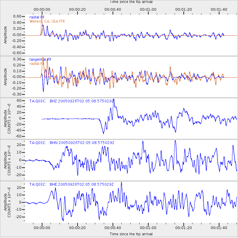
Signal To Noise
| Channel | StoN | STA | LTA |
| TA:Q03C: :BHN:20050926T02:05:08.575029Z | 1.9135735 | 1.4109967E-6 | 7.3736214E-7 |
| TA:Q03C: :BHE:20050926T02:05:08.575029Z | 4.4450336 | 4.0274563E-6 | 9.060576E-7 |
| TA:Q03C: :BHZ:20050926T02:05:08.575029Z | 35.748627 | 1.8537294E-5 | 5.1854556E-7 |
| Arrivals |
| Ps | 3.1 SECOND |
| PpPs | 8.3 SECOND |
| PsPs/PpSs | 11 SECOND |


