You are here: Home > Network List > TA - USArray Transportable Network (new EarthScope stations) Stations List
> Station Q03C Winters, CA, USA > Earthquake Result Viewer
Q03C Winters, CA, USA - Earthquake Result Viewer
| Earthquake location: |
Windward Islands |
| Earthquake latitude/longitude: |
15.0/-61.3 |
| Earthquake time(UTC): |
2007/11/29 (333) 19:00:19 GMT |
| Earthquake Depth: |
148 km |
| Earthquake Magnitude: |
6.9 MB, 7.4 MW, 7.4 MW |
| Earthquake Catalog/Contributor: |
WHDF/NEIC |
|
| Network: |
TA USArray Transportable Network (new EarthScope stations) |
| Station: |
Q03C Winters, CA, USA |
| Lat/Lon: |
38.63 N/122.01 W |
| Elevation: |
108 m |
|
| Distance: |
58.0 deg |
| Az: |
306.339 deg |
| Baz: |
96.262 deg |
| Ray Param: |
0.06264917 |
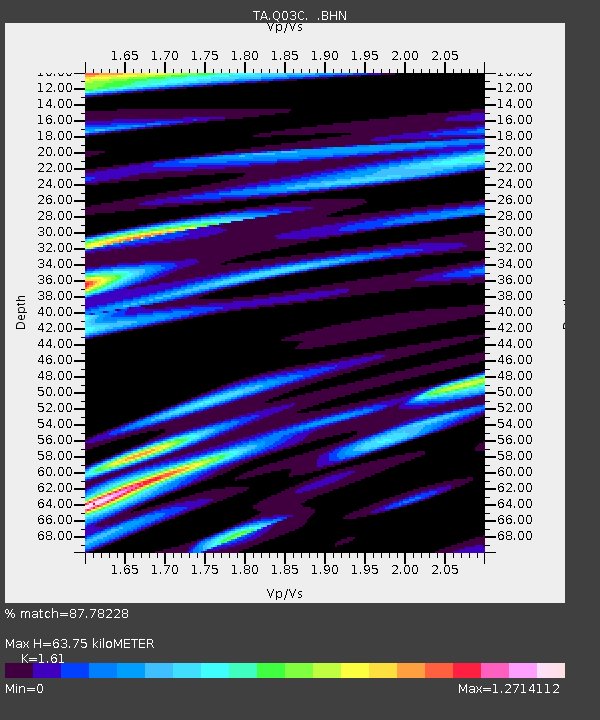
| Estimated Moho Depth: |
63.75 km |
| Estimated Crust Vp/Vs: |
1.61 |
| Assumed Crust Vp: |
6.472 km/s |
| Estimated Crust Vs: |
4.02 km/s |
| Estimated Crust Poisson's Ratio: |
0.19 |
|
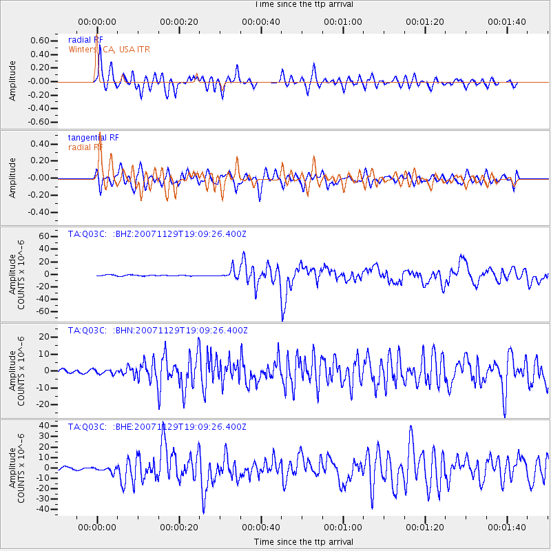
| Radial Match: |
87.78228 % |
| Radial Bump: |
400 |
| Transverse Match: |
76.57541 % |
| Transverse Bump: |
400 |
| SOD ConfigId: |
2564 |
| Insert Time: |
2010-03-07 01:02:38.209 +0000 |
| GWidth: |
2.5 |
| Max Bumps: |
400 |
| Tol: |
0.001 |
|
Signal To Noise
| Channel | StoN | STA | LTA |
| TA:Q03C: :BHN:20071129T19:09:26.400Z | 1.3611165 | 1.2353314E-6 | 9.075868E-7 |
| TA:Q03C: :BHE:20071129T19:09:26.400Z | 2.2503903 | 2.3834918E-6 | 1.059146E-6 |
| TA:Q03C: :BHZ:20071129T19:09:26.400Z | 8.969691 | 7.0363226E-6 | 7.844554E-7 |
| Arrivals |
| Ps | 6.3 SECOND |
| PpPs | 24 SECOND |
| PsPs/PpSs | 31 SECOND |


