You are here: Home > Network List > TA - USArray Transportable Network (new EarthScope stations) Stations List
> Station Q03C Winters, CA, USA > Earthquake Result Viewer
Q03C Winters, CA, USA - Earthquake Result Viewer

| Earthquake location: |
Near Coast Of Peru |
| Earthquake latitude/longitude: |
-13.4/-76.6 |
| Earthquake time(UTC): |
2007/08/15 (227) 23:40:57 GMT |
| Earthquake Depth: |
39 km |
| Earthquake Magnitude: |
6.7 MB, 7.9 MS, 8.0 MW, 7.5 ME |
| Earthquake Catalog/Contributor: |
WHDF/NEIC |
|
| Network: |
TA USArray Transportable Network (new EarthScope stations) |
| Station: |
Q03C Winters, CA, USA |
| Lat/Lon: |
38.63 N/122.01 W |
| Elevation: |
108 m |
|
| Distance: |
66.9 deg |
| Az: |
322.677 deg |
| Baz: |
131.117 deg |
| Ray Param: |
0.05722634 |
| Estimated Moho Depth: |
18.0 km |
| Estimated Crust Vp/Vs: |
2.08 |
| Assumed Crust Vp: |
6.472 km/s |
| Estimated Crust Vs: |
3.108 km/s |
| Estimated Crust Poisson's Ratio: |
0.35 |
|
| Radial Match: |
84.48572 % |
| Radial Bump: |
400 |
| Transverse Match: |
75.41971 % |
| Transverse Bump: |
400 |
| SOD ConfigId: |
2564 |
| Insert Time: |
2010-03-07 01:02:44.480 +0000 |
| GWidth: |
2.5 |
| Max Bumps: |
400 |
| Tol: |
0.001 |
|
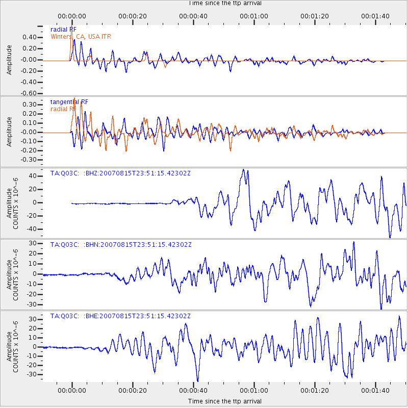
Signal To Noise
| Channel | StoN | STA | LTA |
| TA:Q03C: :BHN:20070815T23:51:15.42302Z | 1.9341143 | 7.2216125E-7 | 3.7338086E-7 |
| TA:Q03C: :BHE:20070815T23:51:15.42302Z | 1.5989017 | 6.085515E-7 | 3.806059E-7 |
| TA:Q03C: :BHZ:20070815T23:51:15.42302Z | 7.3362136 | 2.667316E-6 | 3.635821E-7 |
| Arrivals |
| Ps | 3.1 SECOND |
| PpPs | 8.3 SECOND |
| PsPs/PpSs | 11 SECOND |


