You are here: Home > Network List > TA - USArray Transportable Network (new EarthScope stations) Stations List
> Station M08A Happy Creek Ranch, Winnemucca, NV, USA > Earthquake Result Viewer
M08A Happy Creek Ranch, Winnemucca, NV, USA - Earthquake Result Viewer
| Earthquake location: |
Mariana Islands |
| Earthquake latitude/longitude: |
18.9/145.4 |
| Earthquake time(UTC): |
2007/10/31 (304) 03:30:17 GMT |
| Earthquake Depth: |
223 km |
| Earthquake Magnitude: |
6.2 MB, 7.2 MW, 7.2 MW |
| Earthquake Catalog/Contributor: |
WHDF/NEIC |
|
| Network: |
TA USArray Transportable Network (new EarthScope stations) |
| Station: |
M08A Happy Creek Ranch, Winnemucca, NV, USA |
| Lat/Lon: |
41.45 N/118.38 W |
| Elevation: |
1288 m |
|
| Distance: |
82.3 deg |
| Az: |
48.951 deg |
| Baz: |
288.234 deg |
| Ray Param: |
0.046462614 |
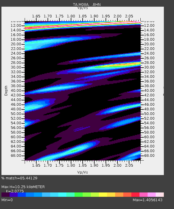
| Estimated Moho Depth: |
10.25 km |
| Estimated Crust Vp/Vs: |
2.08 |
| Assumed Crust Vp: |
6.276 km/s |
| Estimated Crust Vs: |
3.021 km/s |
| Estimated Crust Poisson's Ratio: |
0.35 |
|
| Radial Match: |
85.44129 % |
| Radial Bump: |
400 |
| Transverse Match: |
81.89008 % |
| Transverse Bump: |
400 |
| SOD ConfigId: |
2564 |
| Insert Time: |
2010-03-07 01:07:54.989 +0000 |
| GWidth: |
2.5 |
| Max Bumps: |
400 |
| Tol: |
0.001 |
|
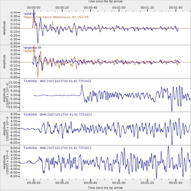
Signal To Noise
| Channel | StoN | STA | LTA |
| TA:M08A: :BHN:20071031T03:41:42.725002Z | 1.5169282 | 6.2893264E-7 | 4.146094E-7 |
| TA:M08A: :BHE:20071031T03:41:42.725002Z | 5.514722 | 1.45435E-6 | 2.637214E-7 |
| TA:M08A: :BHZ:20071031T03:41:42.725002Z | 17.152966 | 4.6739738E-6 | 2.724878E-7 |
| Arrivals |
| Ps | 1.8 SECOND |
| PpPs | 4.9 SECOND |
| PsPs/PpSs | 6.7 SECOND |


