
Station TA M08A - Happy Creek Ranch, Winnemucca, NV, USA
Network: TA - USArray Transportable Network (new EarthScope stations)
Nearby stations (2 deg radius)
| Station | Name | (Lat, Lon) | Start / End | Elevation |
| M08A | Happy Creek Ranch, Winnemucca, NV, USA | (41.45, -118.38) | 2006-02-14 / 2499-01-01 | 1.3 km |
| Crust2 Type: | M5,extended crust, 0.5 km seds. |
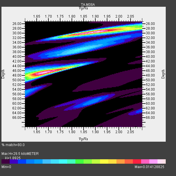
| Thickness Estimate: | 30 km |
| Thickness StdDev: | 8.6 km |
| Vp/Vs Estimate: | 1.89 |
| Vp/Vs StdDev: | 0.12 |
| Vs Estimate: | 3.316 km/s |
| Poisson's Ratio: | 0.31 |
| Peak Value: | 0.01 |
| Assumed Vp: | 6.276 km/s |
| Ps Weight: | 0.33333334 |
| PpPs Weight: | 0.33333334 |
| PsPs Weight: | 0.33333328 |
| Residual Complexity: | 0.728 |
| Nearby stations H: | +- |
| (2.0 deg) Vp/Vs: | +- |
8 with match > 90% ( 21.621622 %) and 37 with match > 80% ( 100.0 %) out of 37.
Download stack as xyz text file.
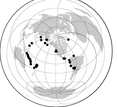
Azimuth Distribution of Events:
Prior Results for this Station
| Study | Thickness | Vp/Vs | Vp | Vs | Poissons Ratio | Extra |
| EARS | 30 km | 1.89 | 6.276 km/s | 3.316 km/s | 0.31 | |
| Crust2.0 | 31 km | 1.78 | 6.276 km/s | 3.529 km/s | 0.27 | M5,extended crust, 0.5 km seds. |
| Global Maxima | 30 km | 1.89 | 6.276 km/s | 3.316 km/s | 0.31 | amp=0.014128825 |
| Local Maxima 1 | 46 km | 1.69 | 6.276 km/s | 3.713 km/s | 0.23 | amp=0.01373725 |
| Local Maxima 2 | 44 km | 1.80 | 6.276 km/s | 3.491 km/s | 0.28 | amp=0.0049238573 |
| Local Maxima 3 | 37 km | 1.84 | 6.276 km/s | 3.415 km/s | 0.29 | amp=0.0048115863 |
| Local Maxima 4 | 50 km | 1.62 | 6.276 km/s | 3.88 km/s | 0.19 | amp=0.0040529873 |
| Predicted Arrivals for vertical incidence (zero ray parameter) | |
| Ps | 4.20 SECOND |
| PpPs | 13.60 SECOND |
| PsPs/PpSs | 17.79 SECOND |
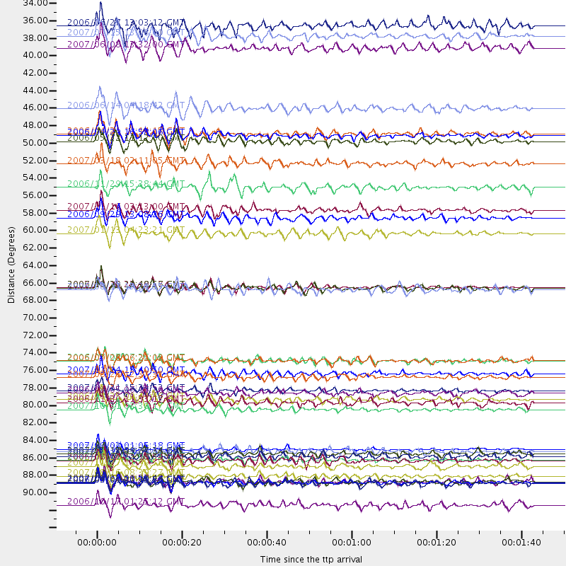
Events Processed for this Station
Download zip of receiver functions as SAC
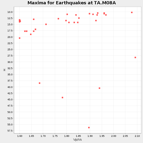
Plot maxima for each earthquake.
Events Used in the Stack
(37 events)| Radial Match | Distance | Baz | FERegion | Time | Lat/Lon | Depth | Magnitude |
| 96.20257 | 87.2 deg | 252.029 deg | Santa Cruz Islands | 2007/09/02 01:05:18 GMT | (-11.6, 165.8) | 35 km | 5.9 MB, 7.3 MS, 7.2 MW, 6.9 ME |
| 95.22273 | 91.5 deg | 260.12 deg | Solomon Islands | 2007/04/01 20:39:56 GMT | (-8.5, 157.0) | 10 km | 6.8 MB, 7.9 MS, 8.1 MW, 7.7 ME |
| 95.19677 | 66.8 deg | 135.14 deg | Near Coast Of Peru | 2007/08/15 23:40:57 GMT | (-13.4, -76.6) | 39 km | 6.7 MB, 7.9 MS, 8.0 MW, 7.5 ME |
| 94.10745 | 88.7 deg | 247.658 deg | Vanuatu Islands | 2006/08/07 22:18:54 GMT | (-15.8, 167.8) | 141 km | 6.0 MB, 6.8 MW, 6.8 MW |
| 92.6316 | 76.1 deg | 232.712 deg | Samoa Islands Region | 2006/09/28 06:22:09 GMT | (-16.6, -172.0) | 28 km | 6.5 MB, 6.6 MS, 6.9 MW, 6.7 MW |
| 92.35908 | 88.6 deg | 247.868 deg | Vanuatu Islands | 2007/08/01 17:08:51 GMT | (-15.6, 167.7) | 120 km | 6.2 MB, 7.2 MW, 7.2 MW |
| 91.76298 | 76.0 deg | 234.796 deg | Tonga Islands | 2006/07/07 07:26:12 GMT | (-15.2, -173.6) | 35 km | 5.7 MB, 5.9 MS, 6.0 MW, 6.0 MW |
| 91.114555 | 87.8 deg | 247.407 deg | Vanuatu Islands | 2007/07/15 09:27:34 GMT | (-15.4, 168.6) | 8.0 km | 6.0 MB, 5.8 MS, 6.1 MW, 6.0 MW |
| 89.442345 | 90.6 deg | 257.512 deg | Solomon Islands | 2007/08/16 08:39:27 GMT | (-9.8, 159.5) | 10 km | 6.1 MB, 6.7 MS, 6.4 MW |
| 89.41011 | 51.1 deg | 124.835 deg | South Of Panama | 2007/03/18 02:11:05 GMT | (4.6, -78.5) | 8.0 km | 6.4 MB, 5.7 MS, 6.2 MW, 6.1 MW |
| 89.381676 | 59.9 deg | 306.775 deg | East Of Kuril Islands | 2007/01/13 04:23:21 GMT | (46.2, 154.5) | 10 km | 7.3 MB, 8.2 MS, 8.1 MW, 7.9 MW |
| 89.082466 | 44.2 deg | 306.323 deg | Rat Islands, Aleutian Islands | 2006/06/14 04:18:42 GMT | (51.8, 177.1) | 14 km | 5.9 MB, 6.4 MS, 6.4 MW, 6.4 MW |
| 88.03536 | 47.4 deg | 320.968 deg | Eastern Siberia, Russia | 2006/04/21 11:14:15 GMT | (61.4, 167.5) | 12 km | 5.8 MB, 5.8 MS, 6.1 MW, 6.1 MW |
| 87.64652 | 87.5 deg | 281.678 deg | South Of Mariana Islands | 2007/09/30 02:08:30 GMT | (10.5, 145.7) | 14 km | 6.4 MB, 7.1 MS, 6.9 MW, 6.9 MW |
| 87.37587 | 57.0 deg | 129.261 deg | Peru-Ecuador Border Region | 2007/11/16 03:13:00 GMT | (-2.3, -77.8) | 123 km | 6.3 MB, 6.8 MW, 6.7 MW |
| 86.315735 | 47.6 deg | 319.816 deg | Eastern Siberia, Russia | 2006/04/29 16:58:06 GMT | (60.5, 167.5) | 11 km | 6.4 MB, 6.6 MS, 6.6 MW, 6.4 MW |
| 85.93598 | 94.3 deg | 266.02 deg | New Britain Region, P.N.G. | 2006/10/17 01:25:12 GMT | (-5.9, 151.0) | 32 km | 6.4 MB, 6.9 MS, 6.7 MW, 6.6 MW |
| 85.44129 | 82.3 deg | 288.234 deg | Mariana Islands | 2007/10/31 03:30:17 GMT | (18.9, 145.4) | 223 km | 6.2 MB, 7.2 MW, 7.2 MW |
| 85.290726 | 91.3 deg | 242.869 deg | Southeast Of Loyalty Islands | 2007/09/27 19:57:44 GMT | (-21.1, 169.3) | 9.0 km | 6.2 MB, 6.3 MS, 6.1 MW, 6.1 MW |
| 85.158455 | 77.7 deg | 134.757 deg | Northern Chile | 2007/11/14 15:40:50 GMT | (-22.2, -69.9) | 40 km | 6.7 MB, 7.4 MS, 7.7 MW, 7.4 ME |
| 84.437 | 35.0 deg | 305.592 deg | Fox Islands, Aleutian Islands | 2007/07/15 13:08:00 GMT | (52.5, -168.0) | 10 km | 5.8 MB, 5.9 MS, 6.1 MW, 6.0 MW |
| 83.94789 | 66.8 deg | 135.247 deg | Near Coast Of Peru | 2006/10/20 10:48:56 GMT | (-13.5, -76.7) | 23 km | 5.9 MB, 6.6 MS, 6.7 MW, 6.6 MW |
| 83.54665 | 81.0 deg | 133.866 deg | Chile-Argentina Border Region | 2006/08/25 00:44:46 GMT | (-24.4, -67.0) | 184 km | 5.9 MB, 6.6 MW, 6.6 MW |
| 83.4773 | 36.5 deg | 130.825 deg | Near Coast Of Guatemala | 2007/06/08 13:32:00 GMT | (13.8, -90.8) | 48 km | 5.5 MB, 5.4 MS, 5.8 MW, 5.8 MW |
| 83.442924 | 54.2 deg | 46.644 deg | North Atlantic Ocean | 2006/11/29 15:38:44 GMT | (53.7, -35.4) | 10 km | 5.6 MB, 5.3 MS, 5.6 MW, 5.6 MW |
| 83.16426 | 48.4 deg | 320.432 deg | Eastern Siberia, Russia | 2006/05/22 11:12:00 GMT | (60.8, 165.7) | 16 km | 6.0 MB, 6.7 MS, 6.6 MW, 6.5 MW |
| 83.06049 | 91.3 deg | 242.745 deg | Southeast Of Loyalty Islands | 2007/09/28 01:01:48 GMT | (-21.2, 169.4) | 10 km | 5.8 MB, 6.4 MS, 6.3 MW, 6.2 MW |
| 83.02224 | 58.0 deg | 104.715 deg | Trinidad | 2006/09/29 13:08:26 GMT | (10.9, -61.8) | 53 km | 5.9 MB, 5.4 MS, 6.1 MW, 6.0 MW |
| 82.82848 | 79.9 deg | 131.566 deg | Jujuy Province, Argentina | 2007/07/21 15:34:52 GMT | (-22.2, -65.8) | 290 km | 5.8 MB, 6.4 MW, 6.3 MW |
| 82.663574 | 78.2 deg | 233.91 deg | Tonga Islands | 2007/08/26 12:37:31 GMT | (-17.5, -174.3) | 127 km | 5.9 MB, 6.1 MW |
| 82.39117 | 33.7 deg | 134.44 deg | Off Coast Of Chiapas, Mexico | 2006/06/27 13:03:12 GMT | (15.0, -94.2) | 29 km | 5.4 MB, 5.5 MS, 5.8 MW, 5.8 MW |
| 82.091805 | 80.2 deg | 232.618 deg | Tonga Islands | 2006/05/05 06:16:20 GMT | (-19.8, -174.7) | 35 km | 5.6 MB, 5.8 MS, 5.9 MW, 5.8 MW |
| 81.767006 | 81.3 deg | 231.701 deg | Tonga Islands | 2006/11/30 11:33:17 GMT | (-21.3, -174.7) | 14 km | 5.7 MB, 6.1 MS, 6.0 MW, 6.0 MW |
| 81.113075 | 67.1 deg | 312.376 deg | Sakhalin, Russia | 2006/08/17 15:20:35 GMT | (46.5, 141.9) | 17 km | 6.0 MB, 5.2 MS, 5.6 MW, 5.5 MW |
| 81.085304 | 88.2 deg | 232.862 deg | South Of Fiji Islands | 2007/10/16 21:05:43 GMT | (-25.8, 179.5) | 509 km | 6.2 MB, 6.6 MW, 6.5 MW |
| 80.69364 | 89.4 deg | 254.917 deg | Solomon Islands | 2007/11/27 11:49:58 GMT | (-10.9, 162.1) | 16 km | 5.9 MB, 6.7 MS, 6.6 MW, 6.4 MW |
| 80.54655 | 91.5 deg | 262.393 deg | Solomon Islands | 2006/09/01 10:18:51 GMT | (-6.8, 155.5) | 38 km | 6.3 MB, 6.7 MS, 6.8 MW, 6.7 MW |
Losers
(0 events)| Radial Match | Distance | Baz | FERegion | Time | Lat/Lon | Depth | Magnitude | Reason |
