You are here: Home > Network List > TA - USArray Transportable Network (new EarthScope stations) Stations List
> Station M08A Happy Creek Ranch, Winnemucca, NV, USA > Earthquake Result Viewer
M08A Happy Creek Ranch, Winnemucca, NV, USA - Earthquake Result Viewer

| Earthquake location: |
South Of Fiji Islands |
| Earthquake latitude/longitude: |
-25.8/179.5 |
| Earthquake time(UTC): |
2007/10/16 (289) 21:05:43 GMT |
| Earthquake Depth: |
509 km |
| Earthquake Magnitude: |
6.2 MB, 6.6 MW, 6.5 MW |
| Earthquake Catalog/Contributor: |
WHDF/NEIC |
|
| Network: |
TA USArray Transportable Network (new EarthScope stations) |
| Station: |
M08A Happy Creek Ranch, Winnemucca, NV, USA |
| Lat/Lon: |
41.45 N/118.38 W |
| Elevation: |
1288 m |
|
| Distance: |
88.2 deg |
| Az: |
41.656 deg |
| Baz: |
232.862 deg |
| Ray Param: |
0.04170133 |
| Estimated Moho Depth: |
13.5 km |
| Estimated Crust Vp/Vs: |
1.92 |
| Assumed Crust Vp: |
6.276 km/s |
| Estimated Crust Vs: |
3.26 km/s |
| Estimated Crust Poisson's Ratio: |
0.32 |
|
| Radial Match: |
81.085304 % |
| Radial Bump: |
400 |
| Transverse Match: |
88.61011 % |
| Transverse Bump: |
341 |
| SOD ConfigId: |
2564 |
| Insert Time: |
2010-03-07 01:07:56.959 +0000 |
| GWidth: |
2.5 |
| Max Bumps: |
400 |
| Tol: |
0.001 |
|
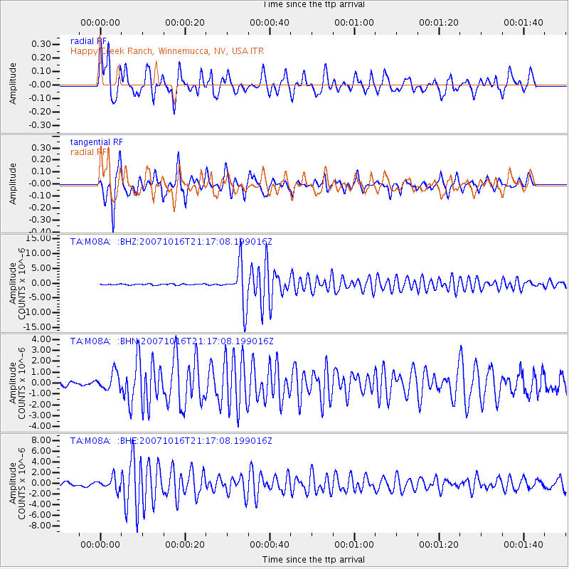
Signal To Noise
| Channel | StoN | STA | LTA |
| TA:M08A: :BHN:20071016T21:17:08.199016Z | 2.6210055 | 8.1632174E-7 | 3.1145368E-7 |
| TA:M08A: :BHE:20071016T21:17:08.199016Z | 3.6891868 | 1.1315694E-6 | 3.0672598E-7 |
| TA:M08A: :BHZ:20071016T21:17:08.199016Z | 36.544563 | 7.2722573E-6 | 1.9899697E-7 |
| Arrivals |
| Ps | 2.0 SECOND |
| PpPs | 6.2 SECOND |
| PsPs/PpSs | 8.2 SECOND |


