You are here: Home > Network List > TA - USArray Transportable Network (new EarthScope stations) Stations List
> Station M08A Happy Creek Ranch, Winnemucca, NV, USA > Earthquake Result Viewer
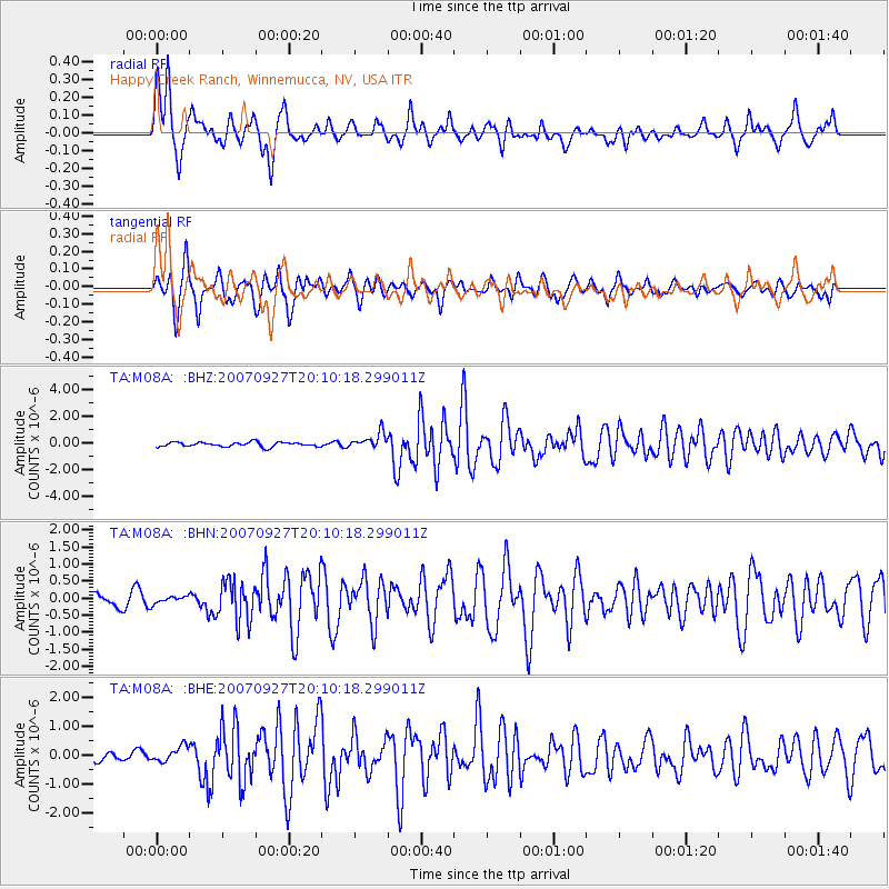
M08A Happy Creek Ranch, Winnemucca, NV, USA - Earthquake Result Viewer

| Earthquake location: |
Southeast Of Loyalty Islands |
| Earthquake latitude/longitude: |
-21.1/169.3 |
| Earthquake time(UTC): |
2007/09/27 (270) 19:57:44 GMT |
| Earthquake Depth: |
9.0 km |
| Earthquake Magnitude: |
6.2 MB, 6.3 MS, 6.1 MW, 6.1 MW |
| Earthquake Catalog/Contributor: |
WHDF/NEIC |
|
| Network: |
TA USArray Transportable Network (new EarthScope stations) |
| Station: |
M08A Happy Creek Ranch, Winnemucca, NV, USA |
| Lat/Lon: |
41.45 N/118.38 W |
| Elevation: |
1288 m |
|
| Distance: |
91.3 deg |
| Az: |
45.767 deg |
| Baz: |
242.869 deg |
| Ray Param: |
0.041610483 |
| Estimated Moho Depth: |
20.5 km |
| Estimated Crust Vp/Vs: |
1.60 |
| Assumed Crust Vp: |
6.276 km/s |
| Estimated Crust Vs: |
3.922 km/s |
| Estimated Crust Poisson's Ratio: |
0.18 |
|
| Radial Match: |
85.290726 % |
| Radial Bump: |
399 |
| Transverse Match: |
80.92594 % |
| Transverse Bump: |
397 |
| SOD ConfigId: |
2564 |
| Insert Time: |
2010-03-07 01:08:02.525 +0000 |
| GWidth: |
2.5 |
| Max Bumps: |
400 |
| Tol: |
0.001 |
|
Signal To Noise
| Channel | StoN | STA | LTA |
| TA:M08A: :BHN:20070927T20:10:18.299011Z | 0.56546277 | 1.0781613E-7 | 1.9066883E-7 |
| TA:M08A: :BHE:20070927T20:10:18.299011Z | 1.5897872 | 2.6493325E-7 | 1.6664697E-7 |
| TA:M08A: :BHZ:20070927T20:10:18.299011Z | 3.4653234 | 5.8342647E-7 | 1.6836134E-7 |
| Arrivals |
| Ps | 2.0 SECOND |
| PpPs | 8.3 SECOND |
| PsPs/PpSs | 10 SECOND |


