You are here: Home > Network List > TA - USArray Transportable Network (new EarthScope stations) Stations List
> Station M08A Happy Creek Ranch, Winnemucca, NV, USA > Earthquake Result Viewer
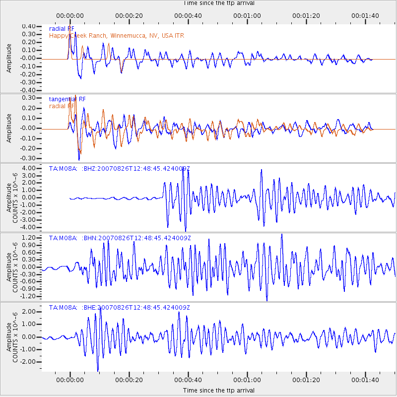
M08A Happy Creek Ranch, Winnemucca, NV, USA - Earthquake Result Viewer

| Earthquake location: |
Tonga Islands |
| Earthquake latitude/longitude: |
-17.5/-174.3 |
| Earthquake time(UTC): |
2007/08/26 (238) 12:37:31 GMT |
| Earthquake Depth: |
127 km |
| Earthquake Magnitude: |
5.9 MB, 6.1 MW |
| Earthquake Catalog/Contributor: |
WHDF/NEIC |
|
| Network: |
TA USArray Transportable Network (new EarthScope stations) |
| Station: |
M08A Happy Creek Ranch, Winnemucca, NV, USA |
| Lat/Lon: |
41.45 N/118.38 W |
| Elevation: |
1288 m |
|
| Distance: |
78.2 deg |
| Az: |
39.527 deg |
| Baz: |
233.91 deg |
| Ray Param: |
0.04952455 |
| Estimated Moho Depth: |
14.25 km |
| Estimated Crust Vp/Vs: |
1.85 |
| Assumed Crust Vp: |
6.276 km/s |
| Estimated Crust Vs: |
3.397 km/s |
| Estimated Crust Poisson's Ratio: |
0.29 |
|
| Radial Match: |
82.663574 % |
| Radial Bump: |
400 |
| Transverse Match: |
77.27267 % |
| Transverse Bump: |
400 |
| SOD ConfigId: |
2564 |
| Insert Time: |
2010-03-07 01:08:09.495 +0000 |
| GWidth: |
2.5 |
| Max Bumps: |
400 |
| Tol: |
0.001 |
|
Signal To Noise
| Channel | StoN | STA | LTA |
| TA:M08A: :BHN:20070826T12:48:45.424009Z | 1.4192867 | 1.3854297E-7 | 9.76145E-8 |
| TA:M08A: :BHE:20070826T12:48:45.424009Z | 3.911078 | 3.3657238E-7 | 8.605617E-8 |
| TA:M08A: :BHZ:20070826T12:48:45.424009Z | 16.669178 | 1.4646175E-6 | 8.786382E-8 |
| Arrivals |
| Ps | 2.0 SECOND |
| PpPs | 6.3 SECOND |
| PsPs/PpSs | 8.3 SECOND |


