You are here: Home > Network List > TA - USArray Transportable Network (new EarthScope stations) Stations List
> Station M08A Happy Creek Ranch, Winnemucca, NV, USA > Earthquake Result Viewer
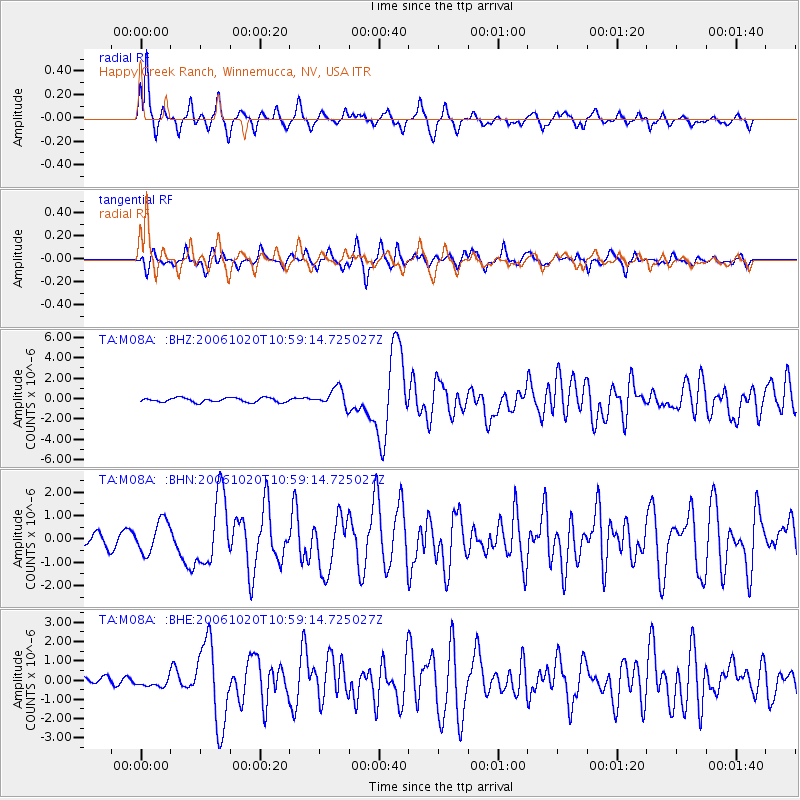
M08A Happy Creek Ranch, Winnemucca, NV, USA - Earthquake Result Viewer
| Earthquake location: |
Near Coast Of Peru |
| Earthquake latitude/longitude: |
-13.5/-76.7 |
| Earthquake time(UTC): |
2006/10/20 (293) 10:48:56 GMT |
| Earthquake Depth: |
23 km |
| Earthquake Magnitude: |
5.9 MB, 6.6 MS, 6.7 MW, 6.6 MW |
| Earthquake Catalog/Contributor: |
WHDF/NEIC |
|
| Network: |
TA USArray Transportable Network (new EarthScope stations) |
| Station: |
M08A Happy Creek Ranch, Winnemucca, NV, USA |
| Lat/Lon: |
41.45 N/118.38 W |
| Elevation: |
1288 m |
|
| Distance: |
66.8 deg |
| Az: |
327.043 deg |
| Baz: |
135.247 deg |
| Ray Param: |
0.057331692 |
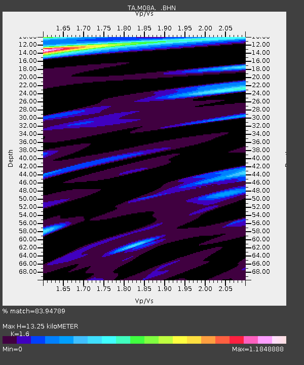
| Estimated Moho Depth: |
13.25 km |
| Estimated Crust Vp/Vs: |
1.60 |
| Assumed Crust Vp: |
6.276 km/s |
| Estimated Crust Vs: |
3.922 km/s |
| Estimated Crust Poisson's Ratio: |
0.18 |
|
| Radial Match: |
83.94789 % |
| Radial Bump: |
400 |
| Transverse Match: |
76.1749 % |
| Transverse Bump: |
400 |
| SOD ConfigId: |
2665 |
| Insert Time: |
2010-03-07 01:08:45.708 +0000 |
| GWidth: |
2.5 |
| Max Bumps: |
400 |
| Tol: |
0.001 |
|
Signal To Noise
| Channel | StoN | STA | LTA |
| TA:M08A: :BHN:20061020T10:59:14.725027Z | 2.9040549 | 6.904025E-7 | 2.3773741E-7 |
| TA:M08A: :BHE:20061020T10:59:14.725027Z | 0.8848981 | 2.6059595E-7 | 2.9449262E-7 |
| TA:M08A: :BHZ:20061020T10:59:14.725027Z | 4.262423 | 8.989879E-7 | 2.1091006E-7 |
| Arrivals |
| Ps | 1.3 SECOND |
| PpPs | 5.3 SECOND |
| PsPs/PpSs | 6.6 SECOND |


