You are here: Home > Network List > TA - USArray Transportable Network (new EarthScope stations) Stations List
> Station M08A Happy Creek Ranch, Winnemucca, NV, USA > Earthquake Result Viewer
M08A Happy Creek Ranch, Winnemucca, NV, USA - Earthquake Result Viewer
| Earthquake location: |
Samoa Islands Region |
| Earthquake latitude/longitude: |
-16.6/-172.0 |
| Earthquake time(UTC): |
2006/09/28 (271) 06:22:09 GMT |
| Earthquake Depth: |
28 km |
| Earthquake Magnitude: |
6.5 MB, 6.6 MS, 6.9 MW, 6.7 MW |
| Earthquake Catalog/Contributor: |
WHDF/NEIC |
|
| Network: |
TA USArray Transportable Network (new EarthScope stations) |
| Station: |
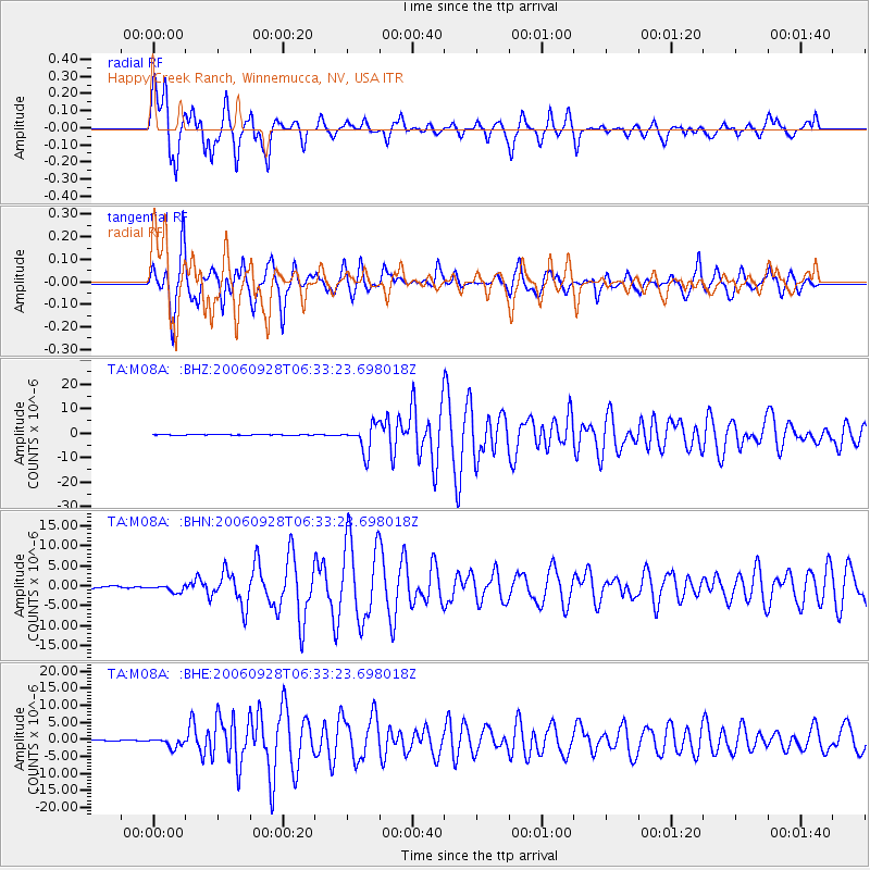
M08A Happy Creek Ranch, Winnemucca, NV, USA |
| Lat/Lon: |
41.45 N/118.38 W |
| Elevation: |
1288 m |
|
| Distance: |
76.1 deg |
| Az: |
38.59 deg |
| Baz: |
232.712 deg |
| Ray Param: |
0.0511791 |
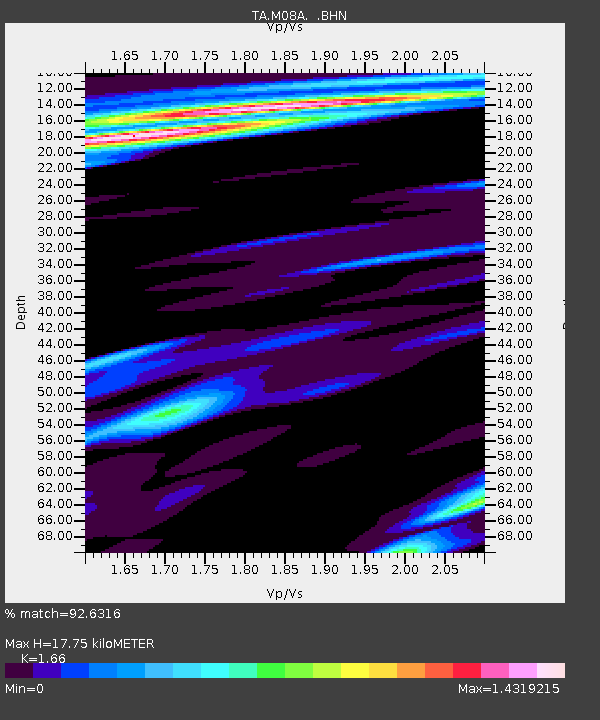
| Estimated Moho Depth: |
17.75 km |
| Estimated Crust Vp/Vs: |
1.66 |
| Assumed Crust Vp: |
6.276 km/s |
| Estimated Crust Vs: |
3.781 km/s |
| Estimated Crust Poisson's Ratio: |
0.22 |
|
| Radial Match: |
92.6316 % |
| Radial Bump: |
400 |
| Transverse Match: |
88.279686 % |
| Transverse Bump: |
395 |
| SOD ConfigId: |
2665 |
| Insert Time: |
2010-03-07 01:08:53.462 +0000 |
| GWidth: |
2.5 |
| Max Bumps: |
400 |
| Tol: |
0.001 |
|
Signal To Noise
| Channel | StoN | STA | LTA |
| TA:M08A: :BHN:20060928T06:33:23.698018Z | 3.4249191 | 8.8257974E-7 | 2.5769359E-7 |
| TA:M08A: :BHE:20060928T06:33:23.698018Z | 13.281646 | 1.412741E-6 | 1.0636792E-7 |
| TA:M08A: :BHZ:20060928T06:33:23.698018Z | 49.52441 | 5.517056E-6 | 1.1140073E-7 |
| Arrivals |
| Ps | 1.9 SECOND |
| PpPs | 7.3 SECOND |
| PsPs/PpSs | 9.2 SECOND |


