You are here: Home > Network List > TA - USArray Transportable Network (new EarthScope stations) Stations List
> Station M08A Happy Creek Ranch, Winnemucca, NV, USA > Earthquake Result Viewer
M08A Happy Creek Ranch, Winnemucca, NV, USA - Earthquake Result Viewer
| Earthquake location: |
Vanuatu Islands |
| Earthquake latitude/longitude: |
-15.8/167.8 |
| Earthquake time(UTC): |
2006/08/07 (219) 22:18:54 GMT |
| Earthquake Depth: |
141 km |
| Earthquake Magnitude: |
6.0 MB, 6.8 MW, 6.8 MW |
| Earthquake Catalog/Contributor: |
WHDF/NEIC |
|
| Network: |
TA USArray Transportable Network (new EarthScope stations) |
| Station: |
M08A Happy Creek Ranch, Winnemucca, NV, USA |
| Lat/Lon: |
41.45 N/118.38 W |
| Elevation: |
1288 m |
|
| Distance: |
88.7 deg |
| Az: |
46.235 deg |
| Baz: |
247.658 deg |
| Ray Param: |
0.042119298 |
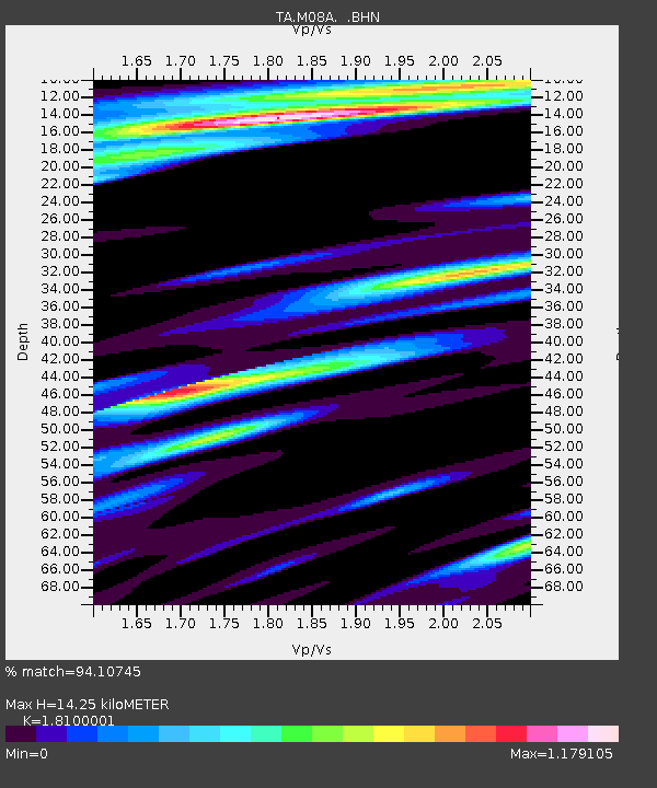
| Estimated Moho Depth: |
14.25 km |
| Estimated Crust Vp/Vs: |
1.81 |
| Assumed Crust Vp: |
6.276 km/s |
| Estimated Crust Vs: |
3.467 km/s |
| Estimated Crust Poisson's Ratio: |
0.28 |
|
| Radial Match: |
94.10745 % |
| Radial Bump: |
400 |
| Transverse Match: |
91.734924 % |
| Transverse Bump: |
400 |
| SOD ConfigId: |
2665 |
| Insert Time: |
2010-03-07 01:08:57.554 +0000 |
| GWidth: |
2.5 |
| Max Bumps: |
400 |
| Tol: |
0.001 |
|
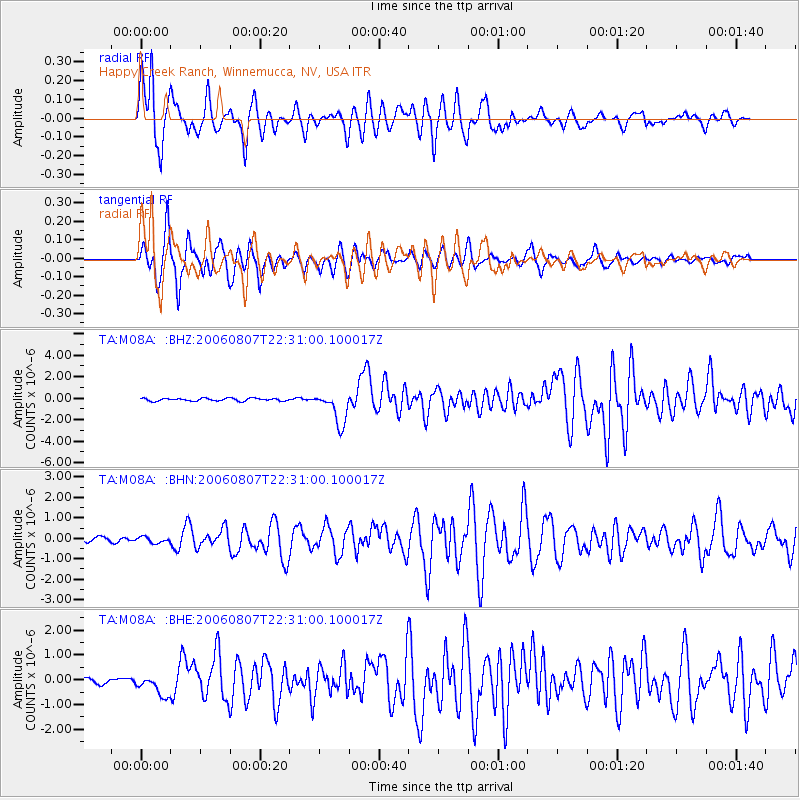
Signal To Noise
| Channel | StoN | STA | LTA |
| TA:M08A: :BHN:20060807T22:31:00.100017Z | 1.2297859 | 1.4369506E-7 | 1.1684559E-7 |
| TA:M08A: :BHE:20060807T22:31:00.100017Z | 3.128232 | 4.1004404E-7 | 1.3107852E-7 |
| TA:M08A: :BHZ:20060807T22:31:00.100017Z | 11.874033 | 1.5202345E-6 | 1.2803017E-7 |
| Arrivals |
| Ps | 1.9 SECOND |
| PpPs | 6.3 SECOND |
| PsPs/PpSs | 8.1 SECOND |


