You are here: Home > Network List > TA - USArray Transportable Network (new EarthScope stations) Stations List
> Station P06A Stead Airport, Stead, NV, USA > Earthquake Result Viewer
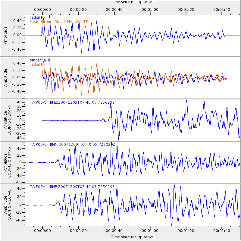
P06A Stead Airport, Stead, NV, USA - Earthquake Result Viewer

| Earthquake location: |
South Of Fiji Islands |
| Earthquake latitude/longitude: |
-26.0/-177.5 |
| Earthquake time(UTC): |
2007/12/09 (343) 07:28:20 GMT |
| Earthquake Depth: |
152 km |
| Earthquake Magnitude: |
7.0 MB, 7.8 MW, 7.7 MW |
| Earthquake Catalog/Contributor: |
WHDF/NEIC |
|
| Network: |
TA USArray Transportable Network (new EarthScope stations) |
| Station: |
P06A Stead Airport, Stead, NV, USA |
| Lat/Lon: |
39.68 N/119.90 W |
| Elevation: |
1369 m |
|
| Distance: |
84.6 deg |
| Az: |
40.894 deg |
| Baz: |
229.769 deg |
| Ray Param: |
0.045041014 |
| Estimated Moho Depth: |
54.75 km |
| Estimated Crust Vp/Vs: |
1.85 |
| Assumed Crust Vp: |
6.279 km/s |
| Estimated Crust Vs: |
3.403 km/s |
| Estimated Crust Poisson's Ratio: |
0.29 |
|
| Radial Match: |
86.91904 % |
| Radial Bump: |
367 |
| Transverse Match: |
77.70273 % |
| Transverse Bump: |
400 |
| SOD ConfigId: |
2564 |
| Insert Time: |
2010-03-07 01:26:19.635 +0000 |
| GWidth: |
2.5 |
| Max Bumps: |
400 |
| Tol: |
0.001 |
|
Signal To Noise
| Channel | StoN | STA | LTA |
| TA:P06A: :BHN:20071209T07:40:05.725029Z | 1.5004642 | 7.3456886E-7 | 4.895611E-7 |
| TA:P06A: :BHE:20071209T07:40:05.725029Z | 1.25527 | 3.3061315E-7 | 2.6338012E-7 |
| TA:P06A: :BHZ:20071209T07:40:05.725029Z | 8.478839 | 1.5870544E-6 | 1.8717827E-7 |
| Arrivals |
| Ps | 7.5 SECOND |
| PpPs | 24 SECOND |
| PsPs/PpSs | 32 SECOND |


