
Station TA P06A - Stead Airport, Stead, NV, USA
Network: TA - USArray Transportable Network (new EarthScope stations)
Nearby stations (2 deg radius)
| Station | Name | (Lat, Lon) | Start / End | Elevation |
| P06A | Stead Airport, Stead, NV, USA | (39.68, -119.90) | 2006-04-28 / 2499-01-01 | 1.4 km |
| Crust2 Type: | M7,medium thick extended crust, 0.5 km seds. |
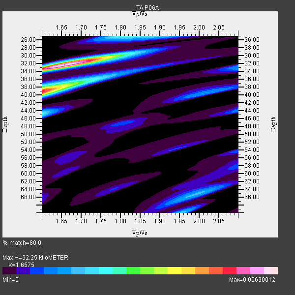
| Thickness Estimate: | 32 km |
| Thickness StdDev: | 4.1 km |
| Vp/Vs Estimate: | 1.66 |
| Vp/Vs StdDev: | 0.04 |
| Vs Estimate: | 3.788 km/s |
| Poisson's Ratio: | 0.21 |
| Peak Value: | 0.06 |
| Assumed Vp: | 6.279 km/s |
| Ps Weight: | 0.33333334 |
| PpPs Weight: | 0.33333334 |
| PsPs Weight: | 0.33333328 |
| Residual Complexity: | 0.655 |
| Nearby stations H: | +- |
| (2.0 deg) Vp/Vs: | +- |
11 with match > 90% ( 26.829268 %) and 41 with match > 80% ( 100.0 %) out of 41.
Download stack as xyz text file.
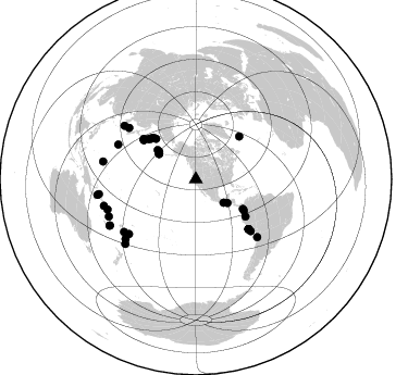
Azimuth Distribution of Events:
Prior Results for this Station
| Study | Thickness | Vp/Vs | Vp | Vs | Poissons Ratio | Extra |
| EARS | 32 km | 1.66 | 6.279 km/s | 3.788 km/s | 0.21 | |
| Crust2.0 | 35 km | 1.78 | 6.279 km/s | 3.533 km/s | 0.27 | M7,medium thick extended crust, 0.5 km seds. |
| Global Maxima | 32 km | 1.66 | 6.279 km/s | 3.788 km/s | 0.21 | amp=0.05630012 |
| Local Maxima 1 | 39 km | 1.60 | 6.279 km/s | 3.924 km/s | 0.18 | amp=0.045745727 |
| Local Maxima 2 | 44 km | 1.60 | 6.279 km/s | 3.924 km/s | 0.18 | amp=0.02043741 |
| Local Maxima 3 | 25 km | 1.80 | 6.279 km/s | 3.488 km/s | 0.28 | amp=0.020269742 |
| Local Maxima 4 | 70 km | 1.96 | 6.279 km/s | 3.212 km/s | 0.32 | amp=0.01578271 |
| Predicted Arrivals for vertical incidence (zero ray parameter) | |
| Ps | 3.38 SECOND |
| PpPs | 13.65 SECOND |
| PsPs/PpSs | 17.03 SECOND |
Events Processed for this Station
Download zip of receiver functions as SAC
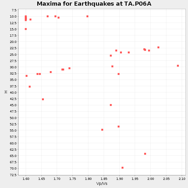
Plot maxima for each earthquake.
Events Used in the Stack
(41 events)| Radial Match | Distance | Baz | FERegion | Time | Lat/Lon | Depth | Magnitude |
| 93.91806 | 86.9 deg | 246.931 deg | Vanuatu Islands | 2007/08/01 17:08:51 GMT | (-15.6, 167.7) | 120 km | 6.2 MB, 7.2 MW, 7.2 MW |
| 93.71787 | 55.9 deg | 312.415 deg | Kamchatka Peninsula, Russia | 2007/05/30 20:22:12 GMT | (52.1, 157.3) | 116 km | 6.4 MB, 6.4 MW, 6.4 MW |
| 93.62612 | 42.3 deg | 306.459 deg | Andreanof Islands, Aleutian Is. | 2007/12/19 09:30:27 GMT | (51.4, -179.5) | 29 km | 6.4 MB, 7.1 MS, 7.1 MW, 7.0 MW |
| 93.516754 | 60.7 deg | 307.829 deg | Kuril Islands | 2006/11/15 11:14:13 GMT | (46.6, 153.3) | 10 km | 6.5 MB, 7.8 MS, 8.3 MW, 7.9 MW |
| 93.290535 | 85.6 deg | 251.127 deg | Santa Cruz Islands | 2007/09/02 01:05:18 GMT | (-11.6, 165.8) | 35 km | 5.9 MB, 7.3 MS, 7.2 MW, 6.9 ME |
| 93.26762 | 60.1 deg | 307.009 deg | East Of Kuril Islands | 2007/01/13 04:23:21 GMT | (46.2, 154.5) | 10 km | 7.3 MB, 8.2 MS, 8.1 MW, 7.9 MW |
| 93.25024 | 51.1 deg | 122.148 deg | South Of Panama | 2007/03/18 02:11:05 GMT | (4.6, -78.5) | 8.0 km | 6.4 MB, 5.7 MS, 6.2 MW, 6.1 MW |
| 92.66914 | 91.6 deg | 261.021 deg | Solomon Islands | 2007/06/28 02:52:09 GMT | (-8.0, 154.6) | 10 km | 6.3 MB, 6.7 MS, 6.7 MW, 6.7 MW |
| 91.85549 | 66.4 deg | 133.367 deg | Near Coast Of Peru | 2006/10/20 10:48:56 GMT | (-13.5, -76.7) | 23 km | 5.9 MB, 6.6 MS, 6.7 MW, 6.6 MW |
| 91.30915 | 41.2 deg | 304.529 deg | Andreanof Islands, Aleutian Is. | 2007/08/16 04:03:03 GMT | (50.2, -177.6) | 15 km | 5.8 MB |
| 90.23345 | 66.4 deg | 133.258 deg | Near Coast Of Peru | 2007/08/15 23:40:57 GMT | (-13.4, -76.6) | 39 km | 6.7 MB, 7.9 MS, 8.0 MW, 7.5 ME |
| 89.40225 | 89.5 deg | 241.754 deg | Southeast Of Loyalty Islands | 2007/09/28 01:01:48 GMT | (-21.2, 169.4) | 10 km | 5.8 MB, 6.4 MS, 6.3 MW, 6.2 MW |
| 89.29359 | 56.2 deg | 311.247 deg | Near East Coast Of Kamchatka | 2006/08/24 21:50:36 GMT | (51.1, 157.5) | 43 km | 5.9 MB, 6.2 MS, 6.5 MW, 6.5 MW |
| 89.19653 | 90.1 deg | 261.386 deg | Solomon Islands | 2006/09/01 10:18:51 GMT | (-6.8, 155.5) | 38 km | 6.3 MB, 6.7 MS, 6.8 MW, 6.7 MW |
| 89.10153 | 87.7 deg | 227.623 deg | Kermadec Islands, New Zealand | 2007/01/31 03:15:52 GMT | (-29.8, -178.0) | 34 km | 6.1 MB, 6.3 MS, 6.5 MW, 6.4 MW |
| 88.44428 | 60.2 deg | 306.967 deg | East Of Kuril Islands | 2006/12/07 19:10:21 GMT | (46.2, 154.4) | 16 km | 6.3 MB, 6.1 MS, 6.3 MW, 6.3 MW |
| 88.322105 | 79.3 deg | 230.828 deg | Tonga Islands | 2006/11/30 11:33:17 GMT | (-21.3, -174.7) | 14 km | 5.7 MB, 6.1 MS, 6.0 MW, 6.0 MW |
| 87.69688 | 52.7 deg | 122.952 deg | Near West Coast Of Colombia | 2007/09/10 01:49:14 GMT | (3.0, -78.0) | 31 km | 6.1 MB, 6.7 MS, 6.8 MW |
| 87.621056 | 89.7 deg | 241.804 deg | Southeast Of Loyalty Islands | 2007/09/28 11:16:39 GMT | (-21.3, 169.1) | 10 km | 5.6 MB, 5.7 MS, 5.9 MW |
| 87.61428 | 42.5 deg | 306.437 deg | Andreanof Islands, Aleutian Is. | 2007/08/02 03:21:42 GMT | (51.3, -180.0) | 21 km | 6.3 MB, 6.6 MS, 6.7 MW, 6.6 MW |
| 87.567825 | 87.8 deg | 253.967 deg | Solomon Islands | 2007/11/27 11:49:58 GMT | (-10.9, 162.1) | 16 km | 5.9 MB, 6.7 MS, 6.6 MW, 6.4 MW |
| 87.41359 | 78.2 deg | 294.032 deg | Bonin Islands, Japan Region | 2006/08/06 18:16:40 GMT | (26.1, 144.0) | 23 km | 6.0 MB, 5.6 MS, 5.8 MW, 5.8 MW |
| 87.230484 | 44.3 deg | 307.506 deg | Rat Islands, Aleutian Islands | 2006/06/14 04:18:42 GMT | (51.8, 177.1) | 14 km | 5.9 MB, 6.4 MS, 6.4 MW, 6.4 MW |
| 86.91904 | 84.6 deg | 229.769 deg | South Of Fiji Islands | 2007/12/09 07:28:20 GMT | (-26.0, -177.5) | 152 km | 7.0 MB, 7.8 MW, 7.7 MW |
| 86.112686 | 54.5 deg | 314.544 deg | Kamchatka Peninsula, Russia | 2006/05/22 13:08:01 GMT | (54.3, 158.4) | 185 km | 6.2 MB, 6.2 MW, 6.2 MW |
| 85.695755 | 41.2 deg | 304.646 deg | Andreanof Islands, Aleutian Is. | 2007/08/15 20:22:11 GMT | (50.3, -177.5) | 9.0 km | 6.3 MB, 6.2 MS, 6.4 MW, 5.9 ML |
| 85.341965 | 42.2 deg | 306.211 deg | Andreanof Islands, Aleutian Is. | 2006/07/08 20:40:00 GMT | (51.2, -179.3) | 22 km | 6.2 MB, 6.4 MS, 6.6 MW, 6.6 MW |
| 84.05772 | 41.9 deg | 306.383 deg | Andreanof Islands, Aleutian Is. | 2007/12/21 07:24:34 GMT | (51.4, -179.0) | 30 km | 6.1 MB, 6.2 MW, 6.3 ML |
| 83.75 | 52.3 deg | 315.376 deg | Near East Coast Of Kamchatka | 2006/08/17 11:11:35 GMT | (55.6, 161.7) | 55 km | 6.1 MB, 5.7 MW, 5.7 MW |
| 83.57893 | 66.6 deg | 133.392 deg | Near Coast Of Peru | 2007/08/17 13:18:13 GMT | (-13.6, -76.6) | 48 km | 5.6 MB, 5.6 MS, 5.9 MW |
| 83.26291 | 56.8 deg | 126.906 deg | Peru-Ecuador Border Region | 2007/11/16 03:13:00 GMT | (-2.3, -77.8) | 123 km | 6.3 MB, 6.8 MW, 6.7 MW |
| 82.919106 | 56.2 deg | 45.335 deg | North Atlantic Ocean | 2006/11/29 15:38:44 GMT | (53.7, -35.4) | 10 km | 5.6 MB, 5.3 MS, 5.6 MW, 5.6 MW |
| 81.9442 | 77.3 deg | 133.312 deg | Northern Chile | 2007/11/14 15:40:50 GMT | (-22.2, -69.9) | 40 km | 6.7 MB, 7.4 MS, 7.7 MW, 7.4 ME |
| 81.929436 | 86.8 deg | 280.791 deg | South Of Mariana Islands | 2007/09/30 02:08:30 GMT | (10.5, 145.7) | 14 km | 6.4 MB, 7.1 MS, 6.9 MW, 6.9 MW |
| 81.666565 | 77.5 deg | 307.523 deg | Sea Of Japan | 2007/07/16 14:17:37 GMT | (36.8, 134.9) | 350 km | 6.2 MB, 6.8 MW, 6.8 MW |
| 81.3086 | 36.3 deg | 126.989 deg | Near Coast Of Guatemala | 2007/06/08 13:32:00 GMT | (13.8, -90.8) | 48 km | 5.5 MB, 5.4 MS, 5.8 MW, 5.8 MW |
| 81.119774 | 33.4 deg | 130.307 deg | Off Coast Of Chiapas, Mexico | 2006/06/27 13:03:12 GMT | (15.0, -94.2) | 29 km | 5.4 MB, 5.5 MS, 5.8 MW, 5.8 MW |
| 81.02449 | 82.2 deg | 306.777 deg | Kyushu, Japan | 2006/06/11 20:01:26 GMT | (33.1, 131.1) | 140 km | 5.9 MB, 6.3 MW, 6.3 MW |
| 80.370346 | 69.2 deg | 133.233 deg | Near Coast Of Peru | 2007/06/28 08:44:48 GMT | (-15.7, -74.9) | 27 km | 5.5 MB, 5.3 MS, 5.8 MW, 5.8 MW |
| 80.24548 | 57.4 deg | 310.132 deg | Kuril Islands | 2006/08/20 03:01:02 GMT | (49.8, 156.4) | 26 km | 5.8 MB, 5.7 MS, 6.0 MW, 5.9 MW |
| 80.17989 | 81.7 deg | 233.816 deg | Fiji Islands Region | 2007/11/19 00:52:12 GMT | (-21.2, -178.8) | 558 km | 6.2 MB, 6.3 MW, 6.3 MW |
Losers
(0 events)| Radial Match | Distance | Baz | FERegion | Time | Lat/Lon | Depth | Magnitude | Reason |
