You are here: Home > Network List > TA - USArray Transportable Network (new EarthScope stations) Stations List
> Station P06A Stead Airport, Stead, NV, USA > Earthquake Result Viewer
P06A Stead Airport, Stead, NV, USA - Earthquake Result Viewer
| Earthquake location: |
Southeast Of Loyalty Islands |
| Earthquake latitude/longitude: |
-21.3/169.1 |
| Earthquake time(UTC): |
2007/09/28 (271) 11:16:39 GMT |
| Earthquake Depth: |
10 km |
| Earthquake Magnitude: |
5.6 MB, 5.7 MS, 5.9 MW |
| Earthquake Catalog/Contributor: |
WHDF/NEIC |
|
| Network: |
TA USArray Transportable Network (new EarthScope stations) |
| Station: |
P06A Stead Airport, Stead, NV, USA |
| Lat/Lon: |
39.68 N/119.90 W |
| Elevation: |
1369 m |
|
| Distance: |
89.7 deg |
| Az: |
46.847 deg |
| Baz: |
241.804 deg |
| Ray Param: |
0.041724063 |
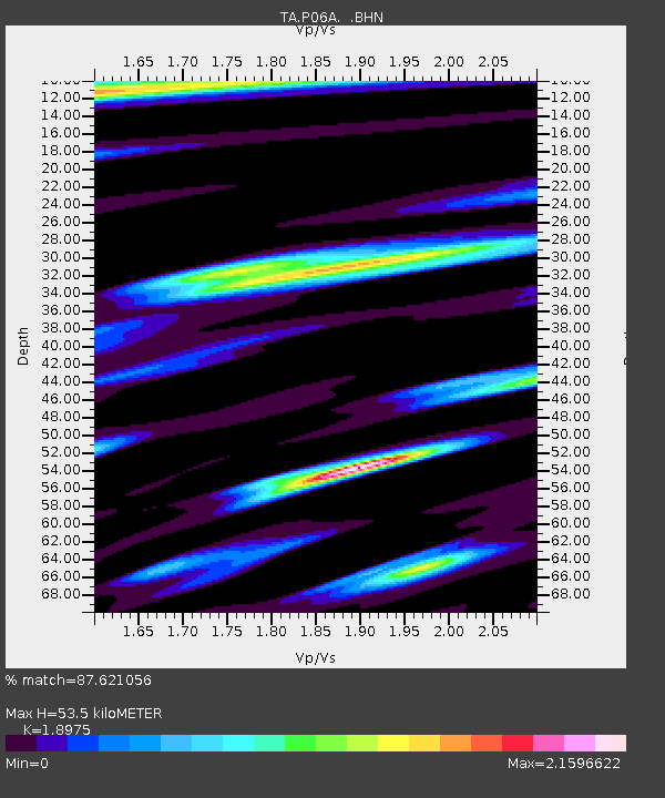
| Estimated Moho Depth: |
53.5 km |
| Estimated Crust Vp/Vs: |
1.90 |
| Assumed Crust Vp: |
6.279 km/s |
| Estimated Crust Vs: |
3.309 km/s |
| Estimated Crust Poisson's Ratio: |
0.31 |
|
| Radial Match: |
87.621056 % |
| Radial Bump: |
400 |
| Transverse Match: |
82.008545 % |
| Transverse Bump: |
400 |
| SOD ConfigId: |
2564 |
| Insert Time: |
2010-03-07 01:26:33.739 +0000 |
| GWidth: |
2.5 |
| Max Bumps: |
400 |
| Tol: |
0.001 |
|
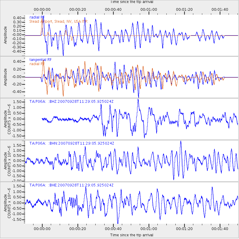
Signal To Noise
| Channel | StoN | STA | LTA |
| TA:P06A: :BHN:20070928T11:29:05.925024Z | 0.951836 | 1.7808453E-7 | 1.8709582E-7 |
| TA:P06A: :BHE:20070928T11:29:05.925024Z | 0.8486513 | 1.6453652E-7 | 1.9388001E-7 |
| TA:P06A: :BHZ:20070928T11:29:05.925024Z | 5.196259 | 5.9840283E-7 | 1.1516031E-7 |
| Arrivals |
| Ps | 7.8 SECOND |
| PpPs | 24 SECOND |
| PsPs/PpSs | 32 SECOND |


