You are here: Home > Network List > TA - USArray Transportable Network (new EarthScope stations) Stations List
> Station P06A Stead Airport, Stead, NV, USA > Earthquake Result Viewer
P06A Stead Airport, Stead, NV, USA - Earthquake Result Viewer
| Earthquake location: |
Sea Of Japan |
| Earthquake latitude/longitude: |
36.8/134.9 |
| Earthquake time(UTC): |
2007/07/16 (197) 14:17:37 GMT |
| Earthquake Depth: |
350 km |
| Earthquake Magnitude: |
6.2 MB, 6.8 MW, 6.8 MW |
| Earthquake Catalog/Contributor: |
WHDF/NEIC |
|
| Network: |
TA USArray Transportable Network (new EarthScope stations) |
| Station: |
P06A Stead Airport, Stead, NV, USA |
| Lat/Lon: |
39.68 N/119.90 W |
| Elevation: |
1369 m |
|
| Distance: |
77.5 deg |
| Az: |
49.697 deg |
| Baz: |
307.523 deg |
| Ray Param: |
0.049301382 |
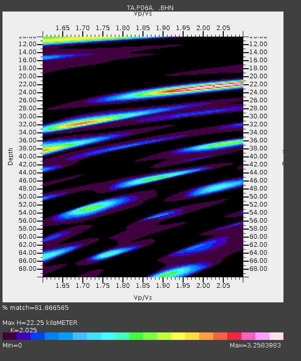
| Estimated Moho Depth: |
22.25 km |
| Estimated Crust Vp/Vs: |
2.03 |
| Assumed Crust Vp: |
6.279 km/s |
| Estimated Crust Vs: |
3.101 km/s |
| Estimated Crust Poisson's Ratio: |
0.34 |
|
| Radial Match: |
81.666565 % |
| Radial Bump: |
400 |
| Transverse Match: |
76.2145 % |
| Transverse Bump: |
400 |
| SOD ConfigId: |
2564 |
| Insert Time: |
2010-03-07 01:26:55.061 +0000 |
| GWidth: |
2.5 |
| Max Bumps: |
400 |
| Tol: |
0.001 |
|
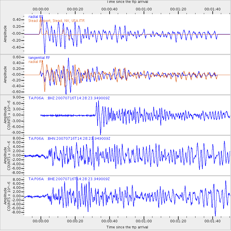
Signal To Noise
| Channel | StoN | STA | LTA |
| TA:P06A: :BHN:20070716T14:28:23.949009Z | 3.5922172 | 7.537126E-7 | 2.0981821E-7 |
| TA:P06A: :BHE:20070716T14:28:23.949009Z | 2.1159542 | 5.483505E-7 | 2.5915048E-7 |
| TA:P06A: :BHZ:20070716T14:28:23.949009Z | 22.031034 | 3.3548474E-6 | 1.5227825E-7 |
| Arrivals |
| Ps | 3.7 SECOND |
| PpPs | 10 SECOND |
| PsPs/PpSs | 14 SECOND |


