You are here: Home > Network List > TA - USArray Transportable Network (new EarthScope stations) Stations List
> Station P06A Stead Airport, Stead, NV, USA > Earthquake Result Viewer
P06A Stead Airport, Stead, NV, USA - Earthquake Result Viewer
| Earthquake location: |
Solomon Islands |
| Earthquake latitude/longitude: |
-8.0/154.6 |
| Earthquake time(UTC): |
2007/06/28 (179) 02:52:09 GMT |
| Earthquake Depth: |
10 km |
| Earthquake Magnitude: |
6.3 MB, 6.7 MS, 6.7 MW, 6.7 MW |
| Earthquake Catalog/Contributor: |
WHDF/NEIC |
|
| Network: |
TA USArray Transportable Network (new EarthScope stations) |
| Station: |
P06A Stead Airport, Stead, NV, USA |
| Lat/Lon: |
39.68 N/119.90 W |
| Elevation: |
1369 m |
|
| Distance: |
91.6 deg |
| Az: |
50.32 deg |
| Baz: |
261.021 deg |
| Ray Param: |
0.041591153 |
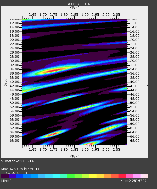
| Estimated Moho Depth: |
69.75 km |
| Estimated Crust Vp/Vs: |
1.91 |
| Assumed Crust Vp: |
6.279 km/s |
| Estimated Crust Vs: |
3.287 km/s |
| Estimated Crust Poisson's Ratio: |
0.31 |
|
| Radial Match: |
92.66914 % |
| Radial Bump: |
400 |
| Transverse Match: |
84.57969 % |
| Transverse Bump: |
400 |
| SOD ConfigId: |
2564 |
| Insert Time: |
2010-03-07 01:26:59.199 +0000 |
| GWidth: |
2.5 |
| Max Bumps: |
400 |
| Tol: |
0.001 |
|
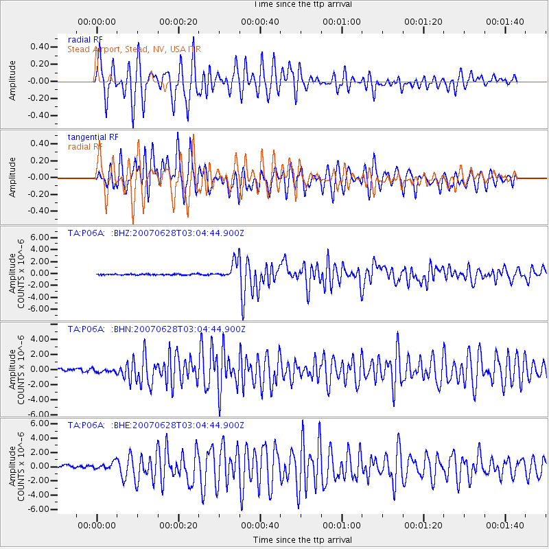
Signal To Noise
| Channel | StoN | STA | LTA |
| TA:P06A: :BHN:20070628T03:04:44.900Z | 1.245783 | 2.0895092E-7 | 1.6772658E-7 |
| TA:P06A: :BHE:20070628T03:04:44.900Z | 2.4240818 | 5.271085E-7 | 2.1744668E-7 |
| TA:P06A: :BHZ:20070628T03:04:44.900Z | 19.704105 | 1.5856414E-6 | 8.0472645E-8 |
| Arrivals |
| Ps | 10 SECOND |
| PpPs | 32 SECOND |
| PsPs/PpSs | 42 SECOND |


