You are here: Home > Network List > TA - USArray Transportable Network (new EarthScope stations) Stations List
> Station P06A Stead Airport, Stead, NV, USA > Earthquake Result Viewer
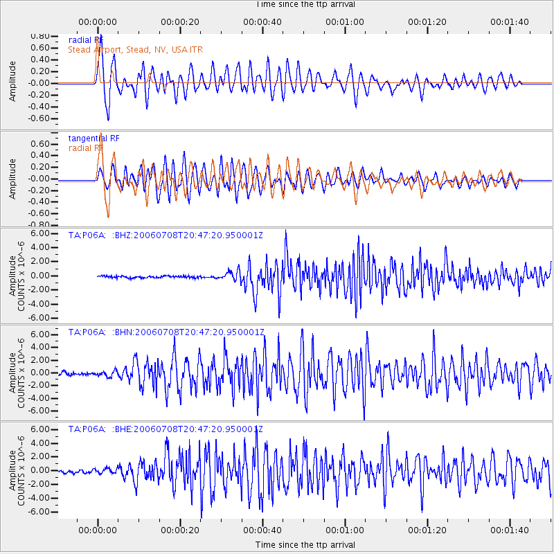
P06A Stead Airport, Stead, NV, USA - Earthquake Result Viewer

| Earthquake location: |
Andreanof Islands, Aleutian Is. |
| Earthquake latitude/longitude: |
51.2/-179.3 |
| Earthquake time(UTC): |
2006/07/08 (189) 20:40:00 GMT |
| Earthquake Depth: |
22 km |
| Earthquake Magnitude: |
6.2 MB, 6.4 MS, 6.6 MW, 6.6 MW |
| Earthquake Catalog/Contributor: |
WHDF/NEIC |
|
| Network: |
TA USArray Transportable Network (new EarthScope stations) |
| Station: |
P06A Stead Airport, Stead, NV, USA |
| Lat/Lon: |
39.68 N/119.90 W |
| Elevation: |
1369 m |
|
| Distance: |
42.2 deg |
| Az: |
81.888 deg |
| Baz: |
306.211 deg |
| Ray Param: |
0.07330998 |
| Estimated Moho Depth: |
25.5 km |
| Estimated Crust Vp/Vs: |
1.87 |
| Assumed Crust Vp: |
6.279 km/s |
| Estimated Crust Vs: |
3.353 km/s |
| Estimated Crust Poisson's Ratio: |
0.30 |
|
| Radial Match: |
85.341965 % |
| Radial Bump: |
400 |
| Transverse Match: |
83.035255 % |
| Transverse Bump: |
400 |
| SOD ConfigId: |
2665 |
| Insert Time: |
2010-03-07 01:27:28.600 +0000 |
| GWidth: |
2.5 |
| Max Bumps: |
400 |
| Tol: |
0.001 |
|
Signal To Noise
| Channel | StoN | STA | LTA |
| TA:P06A: :BHN:20060708T20:47:20.950001Z | 1.5057178 | 4.2339525E-7 | 2.8119163E-7 |
| TA:P06A: :BHE:20060708T20:47:20.950001Z | 1.5190561 | 3.6088176E-7 | 2.3756974E-7 |
| TA:P06A: :BHZ:20060708T20:47:20.950001Z | 5.4064193 | 6.6982255E-7 | 1.2389393E-7 |
| Arrivals |
| Ps | 3.8 SECOND |
| PpPs | 11 SECOND |
| PsPs/PpSs | 15 SECOND |


