You are here: Home > Network List > TA - USArray Transportable Network (new EarthScope stations) Stations List
> Station I07A Izee, OR, USA > Earthquake Result Viewer
I07A Izee, OR, USA - Earthquake Result Viewer
| Earthquake location: |
Northern Chile |
| Earthquake latitude/longitude: |
-22.2/-69.9 |
| Earthquake time(UTC): |
2007/11/14 (318) 15:40:50 GMT |
| Earthquake Depth: |
40 km |
| Earthquake Magnitude: |
6.7 MB, 7.4 MS, 7.7 MW, 7.4 ME |
| Earthquake Catalog/Contributor: |
WHDF/NEIC |
|
| Network: |
TA USArray Transportable Network (new EarthScope stations) |
| Station: |
I07A Izee, OR, USA |
| Lat/Lon: |
44.08 N/119.50 W |
| Elevation: |
1293 m |
|
| Distance: |
80.1 deg |
| Az: |
326.137 deg |
| Baz: |
134.25 deg |
| Ray Param: |
0.048433777 |
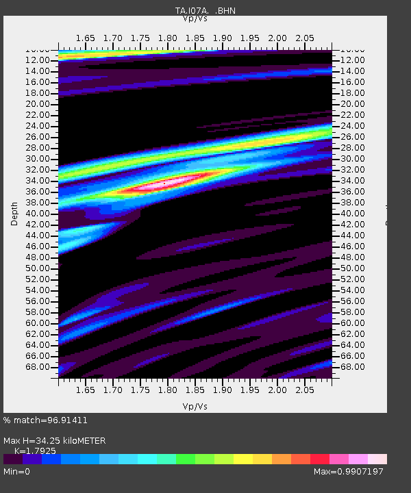
| Estimated Moho Depth: |
34.25 km |
| Estimated Crust Vp/Vs: |
1.79 |
| Assumed Crust Vp: |
6.571 km/s |
| Estimated Crust Vs: |
3.666 km/s |
| Estimated Crust Poisson's Ratio: |
0.27 |
|
| Radial Match: |
96.91411 % |
| Radial Bump: |
400 |
| Transverse Match: |
87.403206 % |
| Transverse Bump: |
400 |
| SOD ConfigId: |
2564 |
| Insert Time: |
2010-03-07 01:27:54.824 +0000 |
| GWidth: |
2.5 |
| Max Bumps: |
400 |
| Tol: |
0.001 |
|
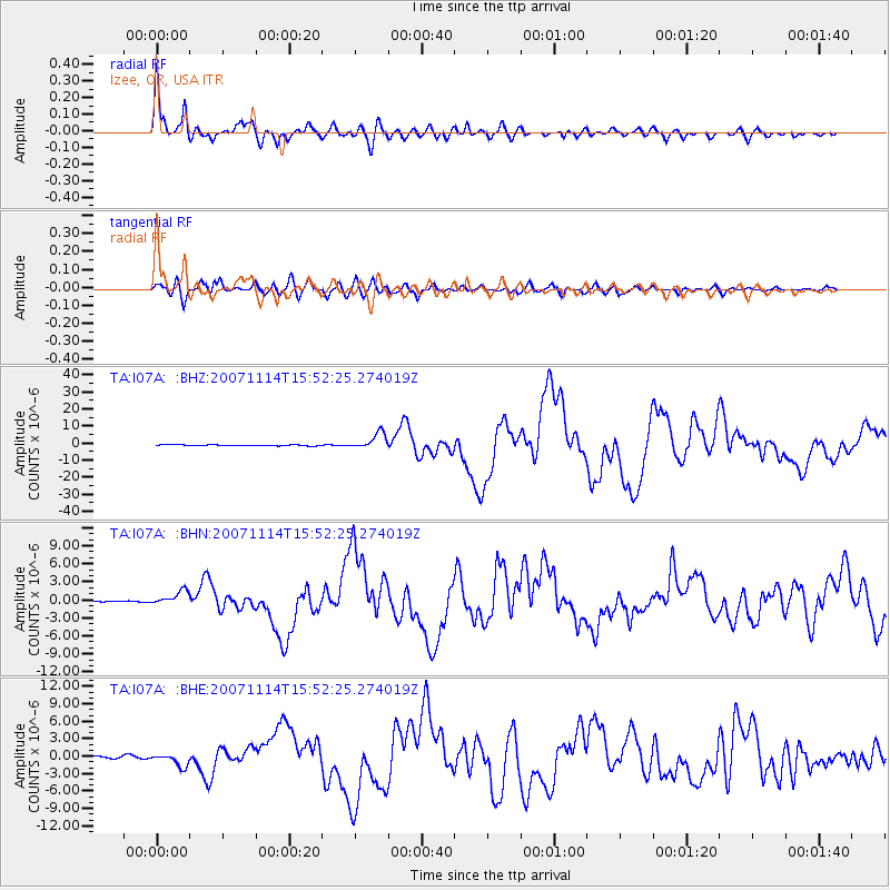
Signal To Noise
| Channel | StoN | STA | LTA |
| TA:I07A: :BHN:20071114T15:52:25.274019Z | 9.892625 | 1.1088472E-6 | 1.1208827E-7 |
| TA:I07A: :BHE:20071114T15:52:25.274019Z | 6.146259 | 1.1000235E-6 | 1.7897449E-7 |
| TA:I07A: :BHZ:20071114T15:52:25.274019Z | 17.884653 | 4.7233E-6 | 2.6409793E-7 |
| Arrivals |
| Ps | 4.3 SECOND |
| PpPs | 14 SECOND |
| PsPs/PpSs | 18 SECOND |


