
Station TA I07A - Izee, OR, USA
Network: TA - USArray Transportable Network (new EarthScope stations)
Nearby stations (2 deg radius)
| Station | Name | (Lat, Lon) | Start / End | Elevation |
| I07A | Izee, OR, USA | (44.08, -119.50) | 2006-07-21 / 2499-01-01 | 1.3 km |
| Crust2 Type: | Q9,orogen/41km no ice, cordilleras, 0.25 km seds. |
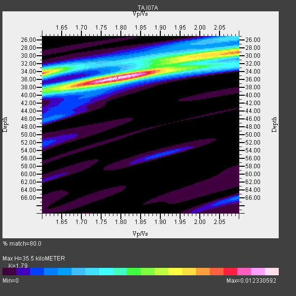
| Thickness Estimate: | 36 km |
| Thickness StdDev: | 2.4 km |
| Vp/Vs Estimate: | 1.79 |
| Vp/Vs StdDev: | 0.15 |
| Vs Estimate: | 3.671 km/s |
| Poisson's Ratio: | 0.27 |
| Peak Value: | 0.01 |
| Assumed Vp: | 6.571 km/s |
| Ps Weight: | 0.33333334 |
| PpPs Weight: | 0.33333334 |
| PsPs Weight: | 0.33333328 |
| Residual Complexity: | 0.627 |
| Nearby stations H: | 34 km +- 2.8 km |
| (2.0 deg) Vp/Vs: | 1.94 +- 0.22 |
21 with match > 90% ( 56.756756 %) and 37 with match > 80% ( 100.0 %) out of 37.
Download stack as xyz text file.
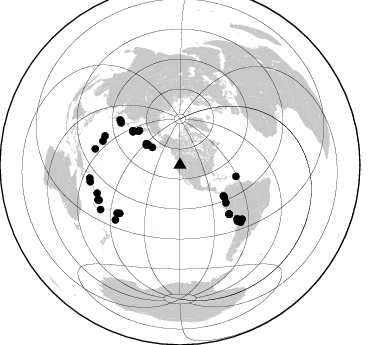
Azimuth Distribution of Events:
Prior Results for this Station
| Study | Thickness | Vp/Vs | Vp | Vs | Poissons Ratio | Extra |
| EARS | 36 km | 1.79 | 6.571 km/s | 3.671 km/s | 0.27 | |
| Crust2.0 | 41 km | 1.76 | 6.571 km/s | 3.735 km/s | 0.26 | Q9,orogen/41km no ice, cordilleras, 0.25 km seds. |
| Global Maxima | 36 km | 1.79 | 6.571 km/s | 3.671 km/s | 0.27 | amp=0.012330592 |
| Local Maxima 1 | 34 km | 1.61 | 6.571 km/s | 4.094 km/s | 0.18 | amp=0.00947171 |
| Local Maxima 2 | 30 km | 2.09 | 6.571 km/s | 3.148 km/s | 0.35 | amp=0.0077643837 |
| Local Maxima 3 | 39 km | 1.60 | 6.571 km/s | 4.107 km/s | 0.18 | amp=0.0046272003 |
| Local Maxima 4 | 28 km | 2.08 | 6.571 km/s | 3.159 km/s | 0.35 | amp=0.0038005398 |
| Predicted Arrivals for vertical incidence (zero ray parameter) | |
| Ps | 4.27 SECOND |
| PpPs | 15.07 SECOND |
| PsPs/PpSs | 19.34 SECOND |
Events Processed for this Station
Download zip of receiver functions as SAC
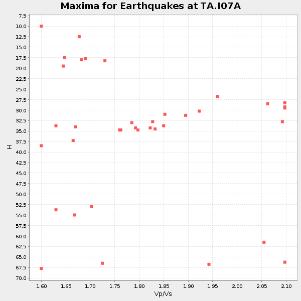
Plot maxima for each earthquake.
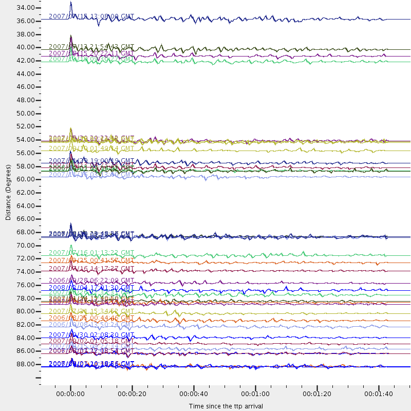
Events Used in the Stack
(37 events)| Radial Match | Distance | Baz | FERegion | Time | Lat/Lon | Depth | Magnitude |
| 98.54382 | 87.3 deg | 251.136 deg | Santa Cruz Islands | 2007/09/02 01:05:18 GMT | (-11.6, 165.8) | 35 km | 5.9 MB, 7.3 MS, 7.2 MW, 6.9 ME |
| 97.91762 | 58.3 deg | 305.909 deg | Kuril Islands | 2006/11/15 11:14:13 GMT | (46.6, 153.3) | 10 km | 6.5 MB, 7.8 MS, 8.3 MW, 7.9 MW |
| 97.662476 | 69.3 deg | 134.893 deg | Near Coast Of Peru | 2007/08/15 23:40:57 GMT | (-13.4, -76.6) | 39 km | 6.7 MB, 7.9 MS, 8.0 MW, 7.5 ME |
| 96.91411 | 80.1 deg | 134.25 deg | Northern Chile | 2007/11/14 15:40:50 GMT | (-22.2, -69.9) | 40 km | 6.7 MB, 7.4 MS, 7.7 MW, 7.4 ME |
| 96.877174 | 57.7 deg | 305.016 deg | East Of Kuril Islands | 2007/01/13 04:23:21 GMT | (46.2, 154.5) | 10 km | 7.3 MB, 8.2 MS, 8.1 MW, 7.9 MW |
| 96.340385 | 54.9 deg | 125.992 deg | Near West Coast Of Colombia | 2007/09/10 01:49:14 GMT | (3.0, -78.0) | 31 km | 6.1 MB, 6.7 MS, 6.8 MW |
| 95.93034 | 88.9 deg | 247.046 deg | Vanuatu Islands | 2007/08/01 17:08:51 GMT | (-15.6, 167.7) | 120 km | 6.2 MB, 7.2 MW, 7.2 MW |
| 95.66066 | 91.1 deg | 259.422 deg | Solomon Islands | 2007/04/01 20:39:56 GMT | (-8.5, 157.0) | 10 km | 6.8 MB, 7.9 MS, 8.1 MW, 7.7 ME |
| 95.06625 | 88.1 deg | 246.548 deg | Vanuatu Islands | 2007/07/15 09:27:34 GMT | (-15.4, 168.6) | 8.0 km | 6.0 MB, 5.8 MS, 6.1 MW, 6.0 MW |
| 94.60092 | 57.0 deg | 101.53 deg | Windward Islands | 2007/11/29 19:00:19 GMT | (15.0, -61.3) | 148 km | 6.9 MB, 7.4 MW, 7.4 MW |
| 93.231544 | 69.3 deg | 134.998 deg | Near Coast Of Peru | 2006/10/20 10:48:56 GMT | (-13.5, -76.7) | 23 km | 5.9 MB, 6.6 MS, 6.7 MW, 6.6 MW |
| 93.13179 | 39.0 deg | 300.31 deg | Andreanof Islands, Aleutian Is. | 2007/08/15 20:22:11 GMT | (50.3, -177.5) | 9.0 km | 6.3 MB, 6.2 MS, 6.4 MW, 5.9 ML |
| 92.987946 | 77.1 deg | 231.335 deg | Samoa Islands Region | 2006/09/28 06:22:09 GMT | (-16.6, -172.0) | 28 km | 6.5 MB, 6.6 MS, 6.9 MW, 6.7 MW |
| 92.679214 | 80.4 deg | 291.183 deg | Volcano Islands, Japan Region | 2007/09/28 13:38:59 GMT | (22.0, 142.7) | 276 km | 6.7 MB, 7.4 MW, 7.4 MW |
| 91.87122 | 53.2 deg | 310.187 deg | Kamchatka Peninsula, Russia | 2007/05/30 20:22:12 GMT | (52.1, 157.3) | 116 km | 6.4 MB, 6.4 MW, 6.4 MW |
| 91.66669 | 72.5 deg | 305.389 deg | Near West Coast Of Honshu, Japan | 2007/07/16 01:13:22 GMT | (37.5, 138.4) | 12 km | 6.5 MB, 6.4 MS, 6.6 MW, 6.5 MW |
| 91.59341 | 75.1 deg | 306.887 deg | Sea Of Japan | 2007/07/16 14:17:37 GMT | (36.8, 134.9) | 350 km | 6.2 MB, 6.8 MW, 6.8 MW |
| 91.20646 | 80.7 deg | 287.134 deg | Mariana Islands | 2007/10/31 03:30:17 GMT | (18.9, 145.4) | 223 km | 6.2 MB, 7.2 MW, 7.2 MW |
| 91.07547 | 83.4 deg | 133.288 deg | Chile-Argentina Border Region | 2006/08/25 00:44:46 GMT | (-24.4, -67.0) | 184 km | 5.9 MB, 6.6 MW, 6.6 MW |
| 90.45267 | 32.8 deg | 302.269 deg | Fox Islands, Aleutian Islands | 2007/07/15 13:08:00 GMT | (52.5, -168.0) | 10 km | 5.8 MB, 5.9 MS, 6.1 MW, 6.0 MW |
| 90.40229 | 69.4 deg | 135.039 deg | Near Coast Of Peru | 2007/08/19 01:22:40 GMT | (-13.6, -76.6) | 26 km | 5.9 MB, 5.4 MS, 5.8 MW, 5.5 ML |
| 89.992226 | 88.9 deg | 246.838 deg | Vanuatu Islands | 2006/08/07 22:18:54 GMT | (-15.8, 167.8) | 141 km | 6.0 MB, 6.8 MW, 6.8 MW |
| 89.68726 | 91.0 deg | 240.807 deg | Southeast Of Loyalty Islands | 2007/07/27 14:46:26 GMT | (-21.5, 170.9) | 10 km | 6.0 MB, 6.0 MS, 6.1 MW, 6.1 MW |
| 89.389366 | 82.2 deg | 131.03 deg | Jujuy Province, Argentina | 2007/07/21 15:34:52 GMT | (-22.2, -65.8) | 290 km | 5.8 MB, 6.4 MW, 6.3 MW |
| 88.65879 | 86.2 deg | 280.785 deg | South Of Mariana Islands | 2007/09/30 02:08:30 GMT | (10.5, 145.7) | 14 km | 6.4 MB, 7.1 MS, 6.9 MW, 6.9 MW |
| 88.33191 | 69.4 deg | 135.012 deg | Near Coast Of Peru | 2007/08/17 13:18:13 GMT | (-13.6, -76.6) | 48 km | 5.6 MB, 5.6 MS, 5.9 MW |
| 88.204956 | 40.0 deg | 302.372 deg | Andreanof Islands, Aleutian Is. | 2007/12/19 09:30:27 GMT | (51.4, -179.5) | 29 km | 6.4 MB, 7.1 MS, 7.1 MW, 7.0 MW |
| 87.3165 | 53.6 deg | 309.006 deg | Near East Coast Of Kamchatka | 2006/08/24 21:50:36 GMT | (51.1, 157.5) | 43 km | 5.9 MB, 6.2 MS, 6.5 MW, 6.5 MW |
| 86.8098 | 37.9 deg | 302.409 deg | Andreanof Islands, Aleutian Is. | 2007/07/13 21:54:43 GMT | (51.8, -176.3) | 35 km | 5.7 MB, 5.6 MS, 6.0 MW, 5.9 MW |
| 85.92421 | 53.3 deg | 125.373 deg | South Of Panama | 2007/03/18 02:11:05 GMT | (4.6, -78.5) | 8.0 km | 6.4 MB, 5.7 MS, 6.2 MW, 6.1 MW |
| 85.646065 | 73.7 deg | 306.286 deg | Near West Coast Of Honshu, Japan | 2007/03/25 00:41:57 GMT | (37.3, 136.6) | 8.0 km | 6.1 MB, 6.8 MS, 6.7 MW, 6.6 MW |
| 85.0485 | 58.3 deg | 305.799 deg | Kuril Islands | 2006/10/01 09:06:02 GMT | (46.5, 153.2) | 19 km | 6.1 MB, 6.4 MS, 6.6 MW, 6.5 MW |
| 84.974754 | 91.1 deg | 261.693 deg | Solomon Islands | 2006/09/01 10:18:51 GMT | (-6.8, 155.5) | 38 km | 6.3 MB, 6.7 MS, 6.8 MW, 6.7 MW |
| 83.11303 | 84.5 deg | 229.662 deg | Tonga Islands Region | 2006/10/08 13:50:24 GMT | (-23.6, -175.3) | 10 km | 5.6 MB, 5.6 MS, 5.8 MW, 5.7 MW |
| 82.78643 | 78.3 deg | 133.189 deg | Near Coast Of Northern Chile | 2008/02/04 17:01:30 GMT | (-20.2, -70.0) | 44 km | 6.0 MB, 6.2 MS, 6.3 MW, 6.3 MW |
| 80.82335 | 79.1 deg | 232.625 deg | Tonga Islands | 2007/08/26 12:37:31 GMT | (-17.5, -174.3) | 127 km | 5.9 MB, 6.1 MW |
| 80.790115 | 59.3 deg | 129.438 deg | Peru-Ecuador Border Region | 2007/11/16 03:13:00 GMT | (-2.3, -77.8) | 123 km | 6.3 MB, 6.8 MW, 6.7 MW |
Losers
(0 events)| Radial Match | Distance | Baz | FERegion | Time | Lat/Lon | Depth | Magnitude | Reason |
