You are here: Home > Network List > TA - USArray Transportable Network (new EarthScope stations) Stations List
> Station I07A Izee, OR, USA > Earthquake Result Viewer
I07A Izee, OR, USA - Earthquake Result Viewer
| Earthquake location: |
Santa Cruz Islands |
| Earthquake latitude/longitude: |
-11.6/165.8 |
| Earthquake time(UTC): |
2007/09/02 (245) 01:05:18 GMT |
| Earthquake Depth: |
35 km |
| Earthquake Magnitude: |
5.9 MB, 7.3 MS, 7.2 MW, 6.9 ME |
| Earthquake Catalog/Contributor: |
WHDF/NEIC |
|
| Network: |
TA USArray Transportable Network (new EarthScope stations) |
| Station: |
I07A Izee, OR, USA |
| Lat/Lon: |
44.08 N/119.50 W |
| Elevation: |
1293 m |
|
| Distance: |
87.3 deg |
| Az: |
44.109 deg |
| Baz: |
251.136 deg |
| Ray Param: |
0.043383945 |
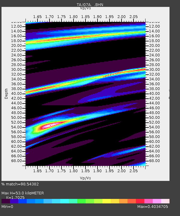
| Estimated Moho Depth: |
53.0 km |
| Estimated Crust Vp/Vs: |
1.70 |
| Assumed Crust Vp: |
6.571 km/s |
| Estimated Crust Vs: |
3.859 km/s |
| Estimated Crust Poisson's Ratio: |
0.24 |
|
| Radial Match: |
98.54382 % |
| Radial Bump: |
260 |
| Transverse Match: |
91.532295 % |
| Transverse Bump: |
400 |
| SOD ConfigId: |
2564 |
| Insert Time: |
2010-03-07 01:28:06.769 +0000 |
| GWidth: |
2.5 |
| Max Bumps: |
400 |
| Tol: |
0.001 |
|

Signal To Noise
| Channel | StoN | STA | LTA |
| TA:I07A: :BHN:20070902T01:17:30.025Z | 2.5651743 | 2.9727727E-7 | 1.1588969E-7 |
| TA:I07A: :BHE:20070902T01:17:30.025Z | 13.866699 | 9.674694E-7 | 6.9769264E-8 |
| TA:I07A: :BHZ:20070902T01:17:30.025Z | 22.960346 | 2.6677549E-6 | 1.1618966E-7 |
| Arrivals |
| Ps | 5.8 SECOND |
| PpPs | 21 SECOND |
| PsPs/PpSs | 27 SECOND |


