You are here: Home > Network List > TA - USArray Transportable Network (new EarthScope stations) Stations List
> Station I07A Izee, OR, USA > Earthquake Result Viewer
I07A Izee, OR, USA - Earthquake Result Viewer

| Earthquake location: |
Tonga Islands |
| Earthquake latitude/longitude: |
-17.5/-174.3 |
| Earthquake time(UTC): |
2007/08/26 (238) 12:37:31 GMT |
| Earthquake Depth: |
127 km |
| Earthquake Magnitude: |
5.9 MB, 6.1 MW |
| Earthquake Catalog/Contributor: |
WHDF/NEIC |
|
| Network: |
TA USArray Transportable Network (new EarthScope stations) |
| Station: |
I07A Izee, OR, USA |
| Lat/Lon: |
44.08 N/119.50 W |
| Elevation: |
1293 m |
|
| Distance: |
79.1 deg |
| Az: |
36.869 deg |
| Baz: |
232.625 deg |
| Ray Param: |
0.048908956 |
| Estimated Moho Depth: |
66.25 km |
| Estimated Crust Vp/Vs: |
2.10 |
| Assumed Crust Vp: |
6.571 km/s |
| Estimated Crust Vs: |
3.133 km/s |
| Estimated Crust Poisson's Ratio: |
0.35 |
|
| Radial Match: |
80.82335 % |
| Radial Bump: |
400 |
| Transverse Match: |
66.49265 % |
| Transverse Bump: |
400 |
| SOD ConfigId: |
2564 |
| Insert Time: |
2010-03-07 01:28:10.117 +0000 |
| GWidth: |
2.5 |
| Max Bumps: |
400 |
| Tol: |
0.001 |
|
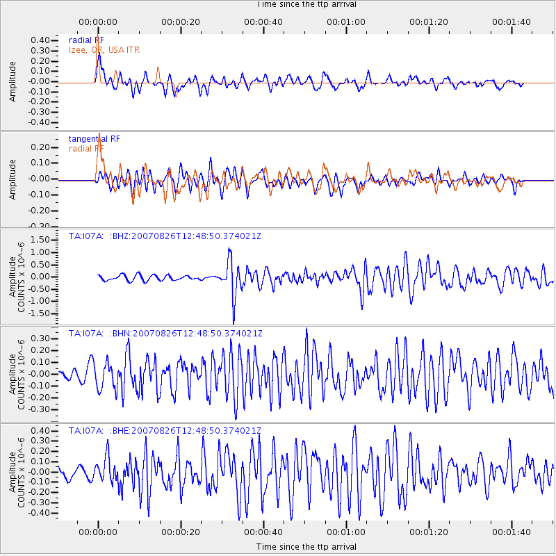
Signal To Noise
| Channel | StoN | STA | LTA |
| TA:I07A: :BHN:20070826T12:48:50.374021Z | 1.8885075 | 1.0737005E-7 | 5.6854446E-8 |
| TA:I07A: :BHE:20070826T12:48:50.374021Z | 1.5869412 | 1.1746896E-7 | 7.4022246E-8 |
| TA:I07A: :BHZ:20070826T12:48:50.374021Z | 6.6264377 | 7.154003E-7 | 1.0796152E-7 |
| Arrivals |
| Ps | 11 SECOND |
| PpPs | 30 SECOND |
| PsPs/PpSs | 42 SECOND |


