You are here: Home > Network List > TA - USArray Transportable Network (new EarthScope stations) Stations List
> Station I07A Izee, OR, USA > Earthquake Result Viewer
I07A Izee, OR, USA - Earthquake Result Viewer
| Earthquake location: |
Near Coast Of Peru |
| Earthquake latitude/longitude: |
-13.6/-76.6 |
| Earthquake time(UTC): |
2007/08/17 (229) 13:18:13 GMT |
| Earthquake Depth: |
48 km |
| Earthquake Magnitude: |
5.6 MB, 5.6 MS, 5.9 MW |
| Earthquake Catalog/Contributor: |
WHDF/NEIC |
|
| Network: |
TA USArray Transportable Network (new EarthScope stations) |
| Station: |
I07A Izee, OR, USA |
| Lat/Lon: |
44.08 N/119.50 W |
| Elevation: |
1293 m |
|
| Distance: |
69.4 deg |
| Az: |
328.399 deg |
| Baz: |
135.012 deg |
| Ray Param: |
0.0555514 |
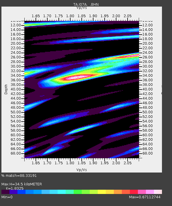
| Estimated Moho Depth: |
34.5 km |
| Estimated Crust Vp/Vs: |
1.83 |
| Assumed Crust Vp: |
6.571 km/s |
| Estimated Crust Vs: |
3.586 km/s |
| Estimated Crust Poisson's Ratio: |
0.29 |
|
| Radial Match: |
88.33191 % |
| Radial Bump: |
400 |
| Transverse Match: |
77.66285 % |
| Transverse Bump: |
400 |
| SOD ConfigId: |
2564 |
| Insert Time: |
2010-03-07 01:28:18.592 +0000 |
| GWidth: |
2.5 |
| Max Bumps: |
400 |
| Tol: |
0.001 |
|
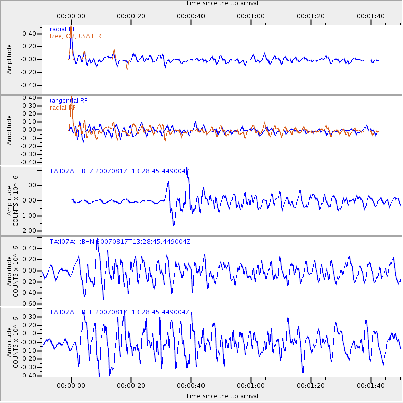
Signal To Noise
| Channel | StoN | STA | LTA |
| TA:I07A: :BHN:20070817T13:28:45.449004Z | 3.427378 | 2.0230725E-7 | 5.9026828E-8 |
| TA:I07A: :BHE:20070817T13:28:45.449004Z | 2.5922687 | 1.6426385E-7 | 6.336683E-8 |
| TA:I07A: :BHZ:20070817T13:28:45.449004Z | 10.476798 | 7.609955E-7 | 7.263626E-8 |
| Arrivals |
| Ps | 4.5 SECOND |
| PpPs | 14 SECOND |
| PsPs/PpSs | 19 SECOND |


