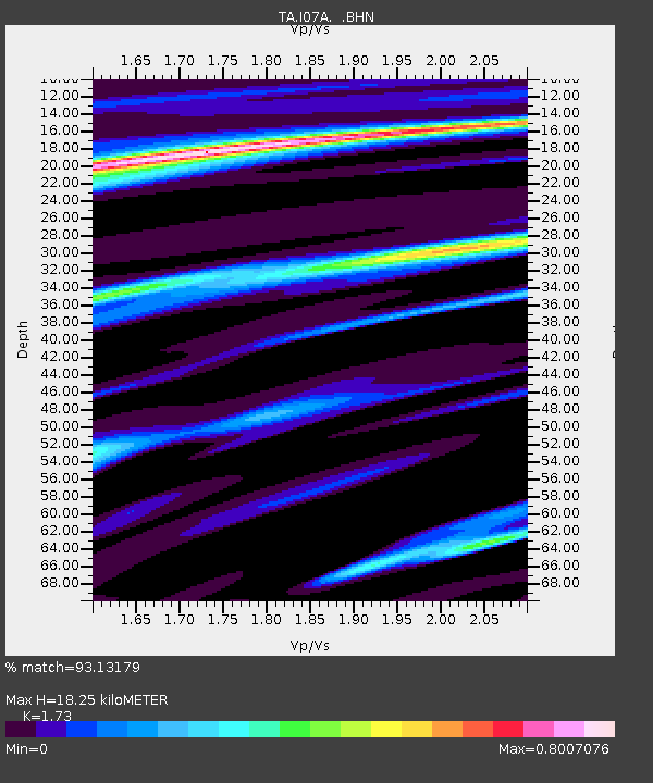
I07A Izee, OR, USA - Earthquake Result Viewer
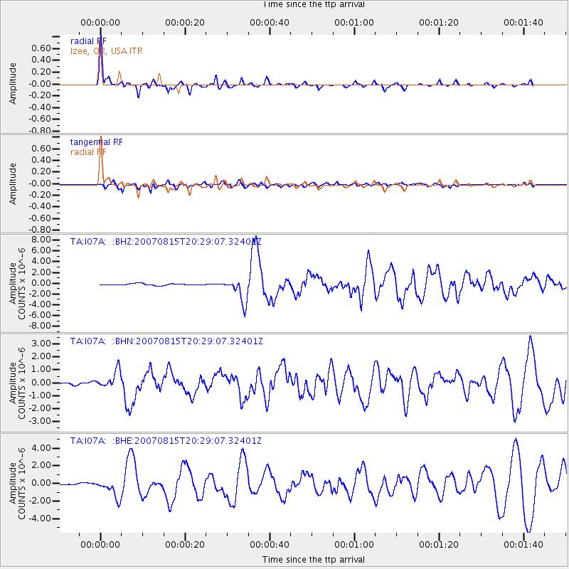
Earthquake location: Andreanof Islands, Aleutian Is.
Earthquake latitude/longitude: 50.3/-177.5
Earthquake time(UTC): 2007/08/15 (227) 20:22:11 GMT
Earthquake Depth: 9.0 km
Earthquake Magnitude: 6.3 MB, 6.2 MS, 6.4 MW, 5.9 ML
Earthquake Catalog/Contributor: WHDF/NEIC
Network: TA USArray Transportable Network (new EarthScope stations)
Station: I07A Izee, OR, USA
Lat/Lon: 44.08 N/119.50 W
Elevation: 1293 m
Distance: 39.0 deg
Az: 76.072 deg
Baz: 300.31 deg
Ray Param: 0.07521166
Estimated Moho Depth: 18.25 km
Estimated Crust Vp/Vs: 1.73
Assumed Crust Vp: 6.571 km/s
Estimated Crust Vs: 3.798 km/s
Estimated Crust Poisson's Ratio: 0.25
Radial Match: 93.13179 %
Radial Bump: 322
Transverse Match: 75.36389 %
Transverse Bump: 400
SOD ConfigId: 2564
Insert Time: 2010-03-07 01:28:23.791 +0000
GWidth: 2.5
Max Bumps: 400
Tol: 0.001

Signal To Noise

ChannelStoNSTALTA
TA:I07A: :BHN:20070815T20:29:07.32401Z4.0557847.0769534E-71.7449038E-7
TA:I07A: :BHE:20070815T20:29:07.32401Z11.2000131.0958474E-69.7843404E-8
TA:I07A: :BHZ:20070815T20:29:07.32401Z15.166742.2867287E-61.5077259E-7
Arrivals
Ps2.2 SECOND
PpPs7.0 SECOND
PsPs/PpSs9.2 SECOND