You are here: Home > Network List > TA - USArray Transportable Network (new EarthScope stations) Stations List
> Station I07A Izee, OR, USA > Earthquake Result Viewer
I07A Izee, OR, USA - Earthquake Result Viewer
| Earthquake location: |
Kuril Islands |
| Earthquake latitude/longitude: |
46.6/153.3 |
| Earthquake time(UTC): |
2006/11/15 (319) 11:14:13 GMT |
| Earthquake Depth: |
10 km |
| Earthquake Magnitude: |
6.5 MB, 7.8 MS, 8.3 MW, 7.9 MW |
| Earthquake Catalog/Contributor: |
WHDF/NEIC |
|
| Network: |
TA USArray Transportable Network (new EarthScope stations) |
| Station: |
I07A Izee, OR, USA |
| Lat/Lon: |
44.08 N/119.50 W |
| Elevation: |
1293 m |
|
| Distance: |
58.3 deg |
| Az: |
57.825 deg |
| Baz: |
305.909 deg |
| Ray Param: |
0.06296054 |
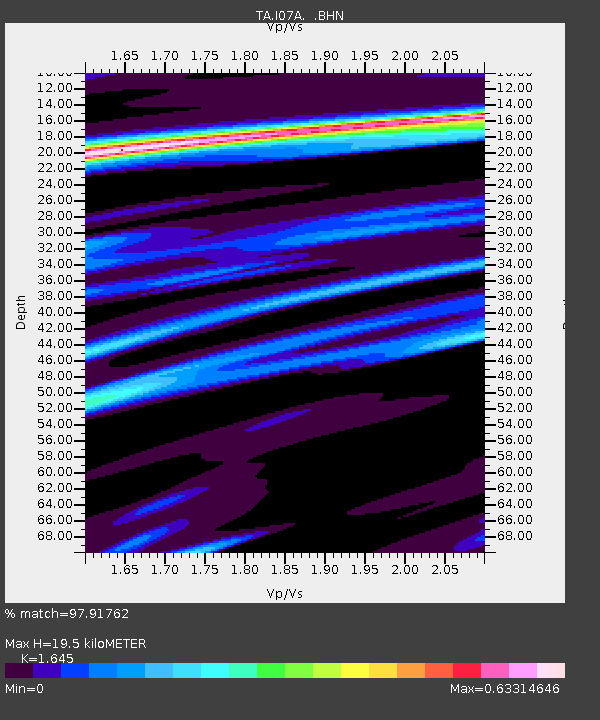
| Estimated Moho Depth: |
19.5 km |
| Estimated Crust Vp/Vs: |
1.64 |
| Assumed Crust Vp: |
6.571 km/s |
| Estimated Crust Vs: |
3.994 km/s |
| Estimated Crust Poisson's Ratio: |
0.21 |
|
| Radial Match: |
97.91762 % |
| Radial Bump: |
250 |
| Transverse Match: |
83.66597 % |
| Transverse Bump: |
400 |
| SOD ConfigId: |
2564 |
| Insert Time: |
2010-03-07 01:28:53.399 +0000 |
| GWidth: |
2.5 |
| Max Bumps: |
400 |
| Tol: |
0.001 |
|

Signal To Noise
| Channel | StoN | STA | LTA |
| TA:I07A: :BHN:20061115T11:23:37.075005Z | 2.4906435 | 5.9879676E-7 | 2.404185E-7 |
| TA:I07A: :BHE:20061115T11:23:37.075005Z | 1.536619 | 4.178975E-7 | 2.719591E-7 |
| TA:I07A: :BHZ:20061115T11:23:37.075005Z | 5.429762 | 1.2034013E-6 | 2.2163059E-7 |
| Arrivals |
| Ps | 2.0 SECOND |
| PpPs | 7.4 SECOND |
| PsPs/PpSs | 9.4 SECOND |


