You are here: Home > Network List > TA - USArray Transportable Network (new EarthScope stations) Stations List
> Station G09A Cove, OR, USA > Earthquake Result Viewer
G09A Cove, OR, USA - Earthquake Result Viewer
| Earthquake location: |
Near Coast Of Peru |
| Earthquake latitude/longitude: |
-13.6/-76.6 |
| Earthquake time(UTC): |
2007/08/17 (229) 13:18:13 GMT |
| Earthquake Depth: |
48 km |
| Earthquake Magnitude: |
5.6 MB, 5.6 MS, 5.9 MW |
| Earthquake Catalog/Contributor: |
WHDF/NEIC |
|
| Network: |
TA USArray Transportable Network (new EarthScope stations) |
| Station: |
G09A Cove, OR, USA |
| Lat/Lon: |
45.28 N/117.78 W |
| Elevation: |
1027 m |
|
| Distance: |
69.4 deg |
| Az: |
330.231 deg |
| Baz: |
136.864 deg |
| Ray Param: |
0.05554872 |
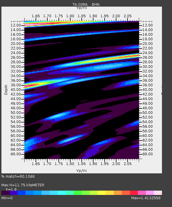
| Estimated Moho Depth: |
11.75 km |
| Estimated Crust Vp/Vs: |
1.60 |
| Assumed Crust Vp: |
6.571 km/s |
| Estimated Crust Vs: |
4.107 km/s |
| Estimated Crust Poisson's Ratio: |
0.18 |
|
| Radial Match: |
90.1068 % |
| Radial Bump: |
400 |
| Transverse Match: |
80.041016 % |
| Transverse Bump: |
400 |
| SOD ConfigId: |
2564 |
| Insert Time: |
2010-03-07 01:33:10.060 +0000 |
| GWidth: |
2.5 |
| Max Bumps: |
400 |
| Tol: |
0.001 |
|
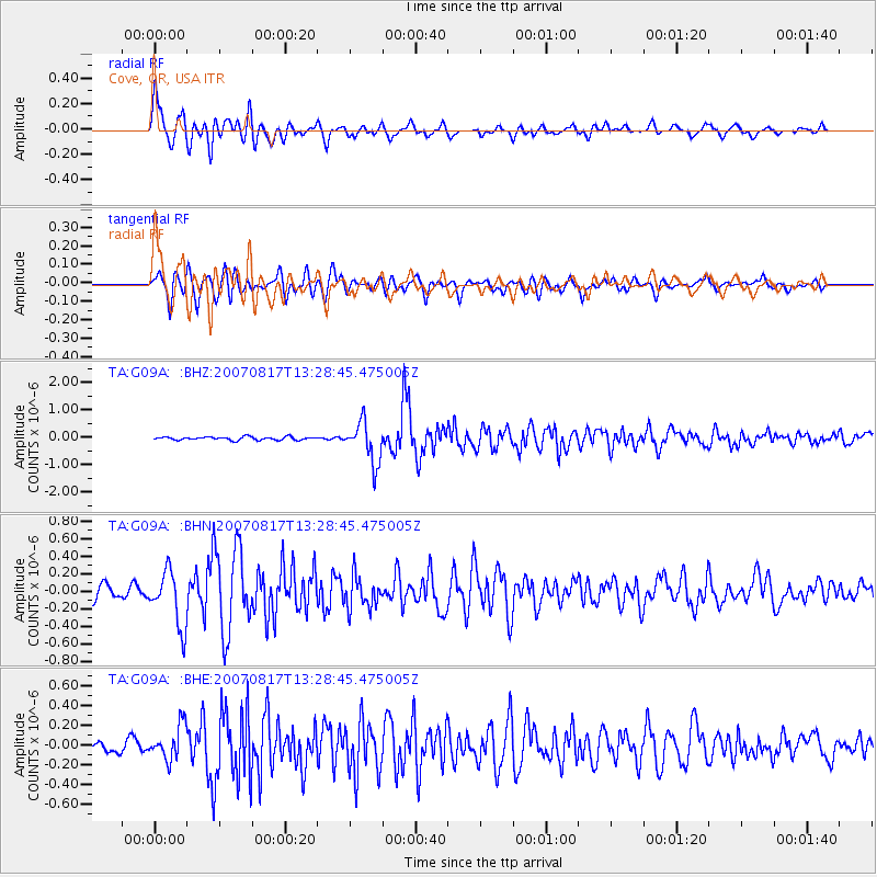
Signal To Noise
| Channel | StoN | STA | LTA |
| TA:G09A: :BHN:20070817T13:28:45.475005Z | 5.509509 | 3.179054E-7 | 5.770122E-8 |
| TA:G09A: :BHE:20070817T13:28:45.475005Z | 3.332909 | 1.7300866E-7 | 5.19092E-8 |
| TA:G09A: :BHZ:20070817T13:28:45.475005Z | 13.103648 | 7.452907E-7 | 5.687658E-8 |
| Arrivals |
| Ps | 1.1 SECOND |
| PpPs | 4.5 SECOND |
| PsPs/PpSs | 5.6 SECOND |


