You are here: Home > Network List > TA - USArray Transportable Network (new EarthScope stations) Stations List
> Station G09A Cove, OR, USA > Earthquake Result Viewer
G09A Cove, OR, USA - Earthquake Result Viewer

| Earthquake location: |
Sea Of Japan |
| Earthquake latitude/longitude: |
36.8/134.9 |
| Earthquake time(UTC): |
2007/07/16 (197) 14:17:37 GMT |
| Earthquake Depth: |
350 km |
| Earthquake Magnitude: |
6.2 MB, 6.8 MW, 6.8 MW |
| Earthquake Catalog/Contributor: |
WHDF/NEIC |
|
| Network: |
TA USArray Transportable Network (new EarthScope stations) |
| Station: |
G09A Cove, OR, USA |
| Lat/Lon: |
45.28 N/117.78 W |
| Elevation: |
1027 m |
|
| Distance: |
75.3 deg |
| Az: |
44.152 deg |
| Baz: |
307.647 deg |
| Ray Param: |
0.050738305 |
| Estimated Moho Depth: |
38.0 km |
| Estimated Crust Vp/Vs: |
1.62 |
| Assumed Crust Vp: |
6.571 km/s |
| Estimated Crust Vs: |
4.062 km/s |
| Estimated Crust Poisson's Ratio: |
0.19 |
|
| Radial Match: |
92.05177 % |
| Radial Bump: |
400 |
| Transverse Match: |
82.37433 % |
| Transverse Bump: |
400 |
| SOD ConfigId: |
2564 |
| Insert Time: |
2010-03-07 01:33:29.362 +0000 |
| GWidth: |
2.5 |
| Max Bumps: |
400 |
| Tol: |
0.001 |
|
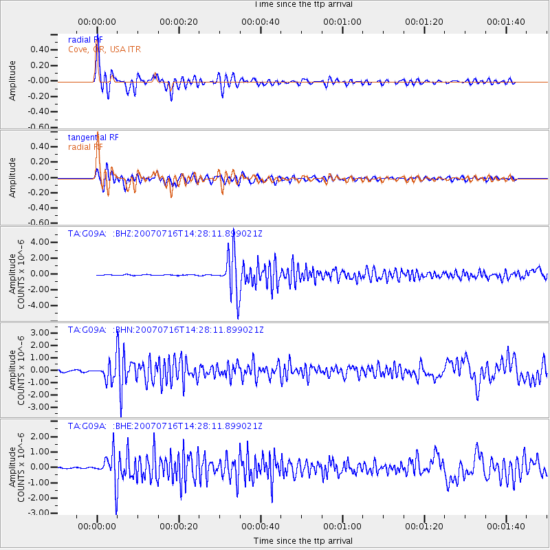
Signal To Noise
| Channel | StoN | STA | LTA |
| TA:G09A: :BHN:20070716T14:28:11.899021Z | 10.350991 | 7.5013435E-7 | 7.246981E-8 |
| TA:G09A: :BHE:20070716T14:28:11.899021Z | 19.31186 | 9.741366E-7 | 5.0442402E-8 |
| TA:G09A: :BHZ:20070716T14:28:11.899021Z | 51.745747 | 2.628892E-6 | 5.080402E-8 |
| Arrivals |
| Ps | 3.7 SECOND |
| PpPs | 15 SECOND |
| PsPs/PpSs | 18 SECOND |


