G09A Cove, OR, USA - Earthquake Result Viewer
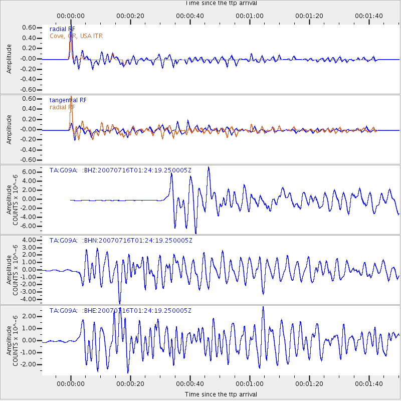
Earthquake location: Near West Coast Of Honshu, Japan
Earthquake latitude/longitude: 37.5/138.4
Earthquake time(UTC): 2007/07/16 (197) 01:13:22 GMT
Earthquake Depth: 12 km
Earthquake Magnitude: 6.5 MB, 6.4 MS, 6.6 MW, 6.5 MW
Earthquake Catalog/Contributor: WHDF/NEIC
Network: TA USArray Transportable Network (new EarthScope stations)
Station: G09A Cove, OR, USA
Lat/Lon: 45.28 N/117.78 W
Elevation: 1027 m
Distance: 72.8 deg
Az: 45.882 deg
Baz: 306.069 deg
Ray Param: 0.05342996
Estimated Moho Depth: 35.5 km
Estimated Crust Vp/Vs: 1.70
Assumed Crust Vp: 6.571 km/s
Estimated Crust Vs: 3.865 km/s
Estimated Crust Poisson's Ratio: 0.24
Radial Match: 93.49308 %
Radial Bump: 370
Transverse Match: 86.13179 %
Transverse Bump: 390
SOD ConfigId: 2564
Insert Time: 2010-03-07 01:33:31.495 +0000
GWidth: 2.5
Max Bumps: 400
Tol: 0.001

Signal To Noise

ChannelStoNSTALTA
TA:G09A: :BHN:20070716T01:24:19.250005Z19.201037.284307E-73.793706E-8
TA:G09A: :BHE:20070716T01:24:19.250005Z11.3370657.0752856E-76.2408446E-8
TA:G09A: :BHZ:20070716T01:24:19.250005Z60.4922262.311074E-63.820448E-8
Arrivals
Ps3.9 SECOND
PpPs14 SECOND
PsPs/PpSs18 SECOND