You are here: Home > Network List > IC - New China Digital Seismograph Network Stations List
> Station HIA Hailar, Neimenggu Autonomous Region, China > Earthquake Result Viewer
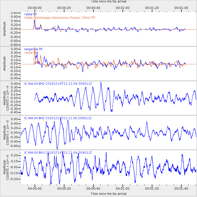
HIA Hailar, Neimenggu Autonomous Region, China - Earthquake Result Viewer
*The percent match for this event was below the threshold and hence no stack was calculated.
| Earthquake location: |
Mariana Islands Region |
| Earthquake latitude/longitude: |
21.4/144.3 |
| Earthquake time(UTC): |
2016/12/14 (349) 21:14:58 GMT |
| Earthquake Depth: |
31 km |
| Earthquake Magnitude: |
5.5 mb |
| Earthquake Catalog/Contributor: |
NEIC PDE/us |
|
| Network: |
IC New China Digital Seismograph Network |
| Station: |
HIA Hailar, Neimenggu Autonomous Region, China |
| Lat/Lon: |
49.27 N/119.74 E |
| Elevation: |
620 m |
|
| Distance: |
34.0 deg |
| Az: |
330.84 deg |
| Baz: |
136.107 deg |
| Ray Param: |
$rayparam |
*The percent match for this event was below the threshold and hence was not used in the summary stack. |
|
| Radial Match: |
67.07492 % |
| Radial Bump: |
400 |
| Transverse Match: |
69.511635 % |
| Transverse Bump: |
400 |
| SOD ConfigId: |
1894071 |
| Insert Time: |
2016-12-28 21:16:06.633 +0000 |
| GWidth: |
2.5 |
| Max Bumps: |
400 |
| Tol: |
0.001 |
|
Signal To Noise
| Channel | StoN | STA | LTA |
| IC:HIA:00:BHZ:20161214T21:21:09.369011Z | 3.0363712 | 3.1200867E-7 | 1.0275709E-7 |
| IC:HIA:00:BH1:20161214T21:21:09.369011Z | 0.9843105 | 8.794457E-8 | 8.9346365E-8 |
| IC:HIA:00:BH2:20161214T21:21:09.369011Z | 3.5345783 | 2.1125112E-7 | 5.976699E-8 |
| Arrivals |
| Ps | |
| PpPs | |
| PsPs/PpSs | |


