You are here: Home > Network List > TA - USArray Transportable Network (new EarthScope stations) Stations List
> Station G09A Cove, OR, USA > Earthquake Result Viewer
G09A Cove, OR, USA - Earthquake Result Viewer
| Earthquake location: |
Northern Mid-Atlantic Ridge |
| Earthquake latitude/longitude: |
52.4/-31.8 |
| Earthquake time(UTC): |
2007/05/23 (143) 04:41:46 GMT |
| Earthquake Depth: |
10 km |
| Earthquake Magnitude: |
5.6 MS, 5.4 MB, 5.7 MW, 5.6 MW |
| Earthquake Catalog/Contributor: |
WHDF/NEIC |
|
| Network: |
TA USArray Transportable Network (new EarthScope stations) |
| Station: |
G09A Cove, OR, USA |
| Lat/Lon: |
45.28 N/117.78 W |
| Elevation: |
1027 m |
|
| Distance: |
53.9 deg |
| Az: |
299.295 deg |
| Baz: |
49.258 deg |
| Ray Param: |
0.06581721 |
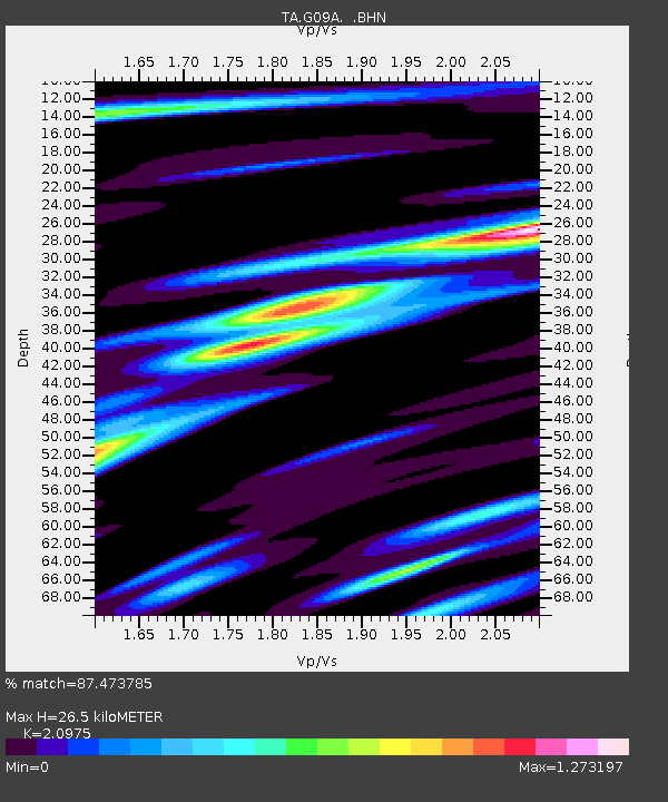
| Estimated Moho Depth: |
26.5 km |
| Estimated Crust Vp/Vs: |
2.10 |
| Assumed Crust Vp: |
6.571 km/s |
| Estimated Crust Vs: |
3.133 km/s |
| Estimated Crust Poisson's Ratio: |
0.35 |
|
| Radial Match: |
87.473785 % |
| Radial Bump: |
400 |
| Transverse Match: |
79.52471 % |
| Transverse Bump: |
400 |
| SOD ConfigId: |
2564 |
| Insert Time: |
2010-03-07 01:33:59.827 +0000 |
| GWidth: |
2.5 |
| Max Bumps: |
400 |
| Tol: |
0.001 |
|

Signal To Noise
| Channel | StoN | STA | LTA |
| TA:G09A: :BHN:20070523T04:50:38.625022Z | 4.303096 | 2.4562706E-7 | 5.708148E-8 |
| TA:G09A: :BHE:20070523T04:50:38.625022Z | 2.6295407 | 1.9697892E-7 | 7.4910005E-8 |
| TA:G09A: :BHZ:20070523T04:50:38.625022Z | 9.264493 | 6.2868764E-7 | 6.785991E-8 |
| Arrivals |
| Ps | 4.6 SECOND |
| PpPs | 12 SECOND |
| PsPs/PpSs | 17 SECOND |


