You are here: Home > Network List > TA - USArray Transportable Network (new EarthScope stations) Stations List
> Station G09A Cove, OR, USA > Earthquake Result Viewer
G09A Cove, OR, USA - Earthquake Result Viewer
| Earthquake location: |
Solomon Islands |
| Earthquake latitude/longitude: |
-7.3/155.7 |
| Earthquake time(UTC): |
2007/04/01 (091) 21:15:22 GMT |
| Earthquake Depth: |
10 km |
| Earthquake Magnitude: |
6.0 MB |
| Earthquake Catalog/Contributor: |
WHDF/NEIC |
|
| Network: |
TA USArray Transportable Network (new EarthScope stations) |
| Station: |
G09A Cove, OR, USA |
| Lat/Lon: |
45.28 N/117.78 W |
| Elevation: |
1027 m |
|
| Distance: |
92.7 deg |
| Az: |
44.874 deg |
| Baz: |
262.43 deg |
| Ray Param: |
0.041406408 |
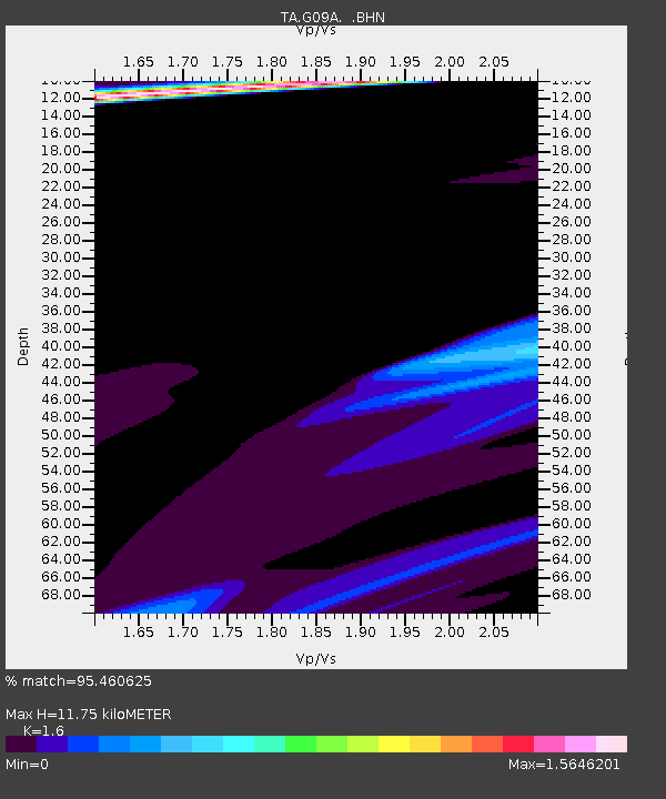
| Estimated Moho Depth: |
11.75 km |
| Estimated Crust Vp/Vs: |
1.60 |
| Assumed Crust Vp: |
6.571 km/s |
| Estimated Crust Vs: |
4.107 km/s |
| Estimated Crust Poisson's Ratio: |
0.18 |
|
| Radial Match: |
95.460625 % |
| Radial Bump: |
367 |
| Transverse Match: |
86.06489 % |
| Transverse Bump: |
289 |
| SOD ConfigId: |
2564 |
| Insert Time: |
2010-03-07 01:34:01.490 +0000 |
| GWidth: |
2.5 |
| Max Bumps: |
400 |
| Tol: |
0.001 |
|
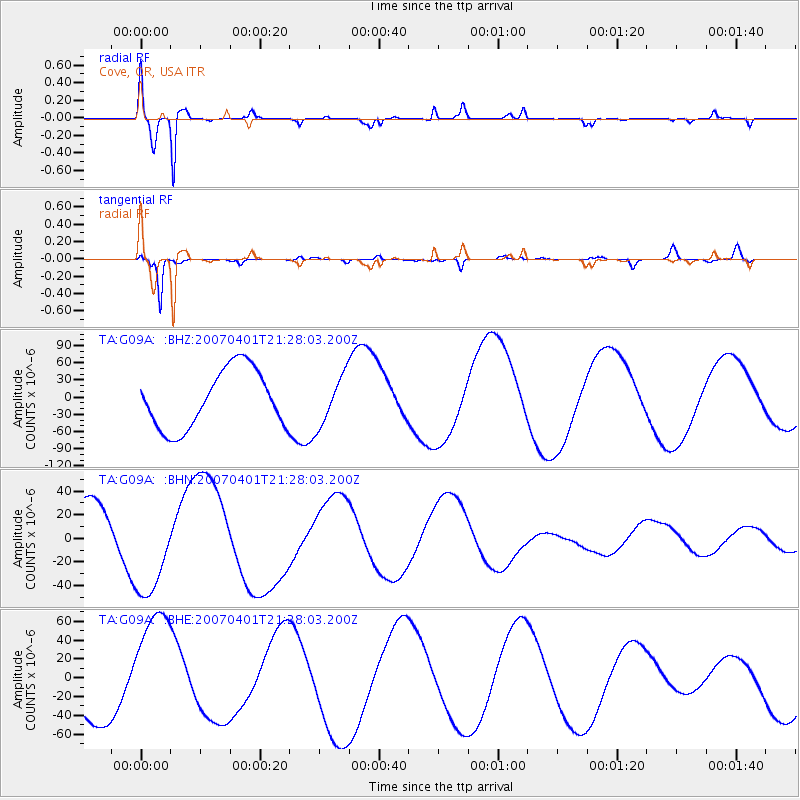
Signal To Noise
| Channel | StoN | STA | LTA |
| TA:G09A: :BHN:20070401T21:28:03.200Z | 1.6631322 | 4.0788862E-5 | 2.4525329E-5 |
| TA:G09A: :BHE:20070401T21:28:03.200Z | 1.7591288 | 6.6478555E-5 | 3.7790614E-5 |
| TA:G09A: :BHZ:20070401T21:28:03.200Z | 0.8481877 | 4.326605E-5 | 5.1009996E-5 |
| Arrivals |
| Ps | 1.1 SECOND |
| PpPs | 4.5 SECOND |
| PsPs/PpSs | 5.6 SECOND |


