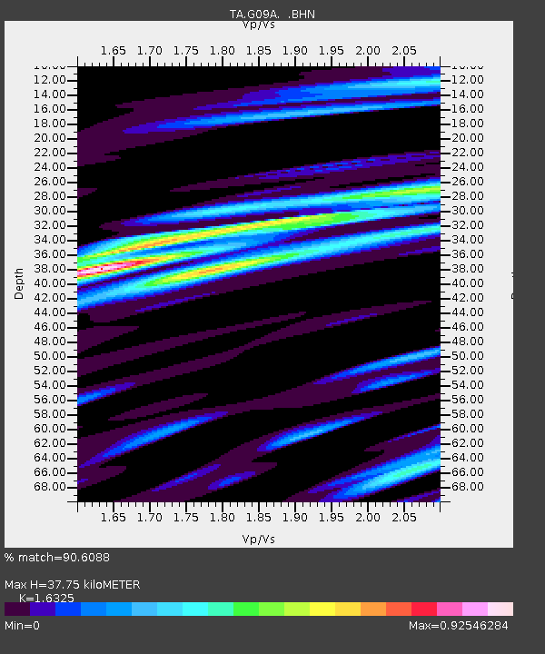
G09A Cove, OR, USA - Earthquake Result Viewer

Earthquake location: Near West Coast Of Honshu, Japan
Earthquake latitude/longitude: 37.3/136.6
Earthquake time(UTC): 2007/03/25 (084) 00:41:57 GMT
Earthquake Depth: 8.0 km
Earthquake Magnitude: 6.1 MB, 6.8 MS, 6.7 MW, 6.6 MW
Earthquake Catalog/Contributor: WHDF/NEIC
Network: TA USArray Transportable Network (new EarthScope stations)
Station: G09A Cove, OR, USA
Lat/Lon: 45.28 N/117.78 W
Elevation: 1027 m
Distance: 74.0 deg
Az: 45.025 deg
Baz: 307.004 deg
Ray Param: 0.05264764
Estimated Moho Depth: 37.75 km
Estimated Crust Vp/Vs: 1.63
Assumed Crust Vp: 6.571 km/s
Estimated Crust Vs: 4.025 km/s
Estimated Crust Poisson's Ratio: 0.20
Radial Match: 90.6088 %
Radial Bump: 400
Transverse Match: 77.68408 %
Transverse Bump: 400
SOD ConfigId: 2564
Insert Time: 2010-03-07 01:34:04.897 +0000
GWidth: 2.5
Max Bumps: 400
Tol: 0.001

Signal To Noise

ChannelStoNSTALTA
TA:G09A: :BHN:20070325T00:53:02.374016Z2.68979551.1626784E-64.3225532E-7
TA:G09A: :BHE:20070325T00:53:02.374016Z1.75075971.6633954E-69.5009926E-7
TA:G09A: :BHZ:20070325T00:53:02.374016Z2.06714685.522615E-62.6716125E-6
Arrivals
Ps3.8 SECOND
PpPs15 SECOND
PsPs/PpSs18 SECOND