You are here: Home > Network List > TA - USArray Transportable Network (new EarthScope stations) Stations List
> Station G09A Cove, OR, USA > Earthquake Result Viewer
G09A Cove, OR, USA - Earthquake Result Viewer
| Earthquake location: |
Trinidad |
| Earthquake latitude/longitude: |
10.9/-61.8 |
| Earthquake time(UTC): |
2006/09/29 (272) 13:08:26 GMT |
| Earthquake Depth: |
53 km |
| Earthquake Magnitude: |
5.9 MB, 5.4 MS, 6.1 MW, 6.0 MW |
| Earthquake Catalog/Contributor: |
WHDF/NEIC |
|
| Network: |
TA USArray Transportable Network (new EarthScope stations) |
| Station: |
G09A Cove, OR, USA |
| Lat/Lon: |
45.28 N/117.78 W |
| Elevation: |
1027 m |
|
| Distance: |
58.6 deg |
| Az: |
316.714 deg |
| Baz: |
107.471 deg |
| Ray Param: |
0.06258385 |
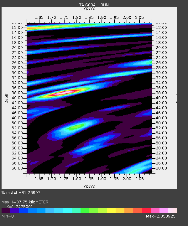
| Estimated Moho Depth: |
37.75 km |
| Estimated Crust Vp/Vs: |
1.75 |
| Assumed Crust Vp: |
6.571 km/s |
| Estimated Crust Vs: |
3.76 km/s |
| Estimated Crust Poisson's Ratio: |
0.26 |
|
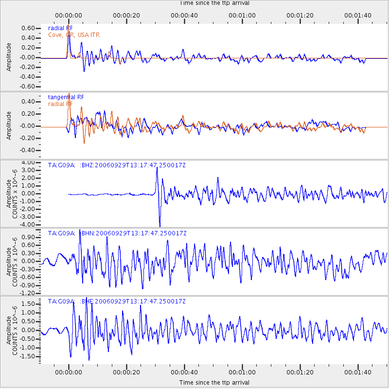
| Radial Match: |
81.26997 % |
| Radial Bump: |
400 |
| Transverse Match: |
60.47594 % |
| Transverse Bump: |
400 |
| SOD ConfigId: |
2564 |
| Insert Time: |
2010-03-07 01:34:08.281 +0000 |
| GWidth: |
2.5 |
| Max Bumps: |
400 |
| Tol: |
0.001 |
|
Signal To Noise
| Channel | StoN | STA | LTA |
| TA:G09A: :BHN:20060929T13:17:47.250017Z | 4.041006 | 3.9185142E-7 | 9.696877E-8 |
| TA:G09A: :BHE:20060929T13:17:47.250017Z | 5.0400953 | 7.4818973E-7 | 1.4844754E-7 |
| TA:G09A: :BHZ:20060929T13:17:47.250017Z | 25.928814 | 1.6101552E-6 | 6.209907E-8 |
| Arrivals |
| Ps | 4.5 SECOND |
| PpPs | 15 SECOND |
| PsPs/PpSs | 20 SECOND |


