You are here: Home > Network List > TA - USArray Transportable Network (new EarthScope stations) Stations List
> Station G09A Cove, OR, USA > Earthquake Result Viewer
G09A Cove, OR, USA - Earthquake Result Viewer

| Earthquake location: |
Kuril Islands |
| Earthquake latitude/longitude: |
46.4/153.2 |
| Earthquake time(UTC): |
2008/03/03 (063) 09:31:02 GMT |
| Earthquake Depth: |
10 km |
| Earthquake Magnitude: |
6.2 MB, 6.5 MS, 6.5 MW, 6.5 MW |
| Earthquake Catalog/Contributor: |
WHDF/NEIC |
|
| Network: |
TA USArray Transportable Network (new EarthScope stations) |
| Station: |
G09A Cove, OR, USA |
| Lat/Lon: |
45.28 N/117.78 W |
| Elevation: |
1027 m |
|
| Distance: |
58.7 deg |
| Az: |
55.702 deg |
| Baz: |
305.939 deg |
| Ray Param: |
0.062667854 |
| Estimated Moho Depth: |
35.75 km |
| Estimated Crust Vp/Vs: |
1.64 |
| Assumed Crust Vp: |
6.571 km/s |
| Estimated Crust Vs: |
4.013 km/s |
| Estimated Crust Poisson's Ratio: |
0.20 |
|
| Radial Match: |
88.574455 % |
| Radial Bump: |
400 |
| Transverse Match: |
77.45526 % |
| Transverse Bump: |
400 |
| SOD ConfigId: |
2564 |
| Insert Time: |
2010-03-07 01:34:18.091 +0000 |
| GWidth: |
2.5 |
| Max Bumps: |
400 |
| Tol: |
0.001 |
|
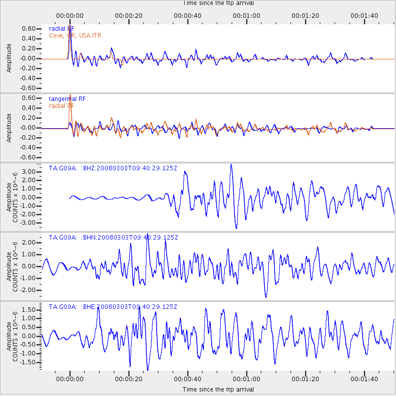
Signal To Noise
| Channel | StoN | STA | LTA |
| TA:G09A: :BHN:20080303T09:40:29.125Z | 0.6828856 | 2.0089205E-7 | 2.9418112E-7 |
| TA:G09A: :BHE:20080303T09:40:29.125Z | 1.0878167 | 2.5015947E-7 | 2.2996473E-7 |
| TA:G09A: :BHZ:20080303T09:40:29.125Z | 3.072301 | 3.759672E-7 | 1.2237317E-7 |
| Arrivals |
| Ps | 3.7 SECOND |
| PpPs | 14 SECOND |
| PsPs/PpSs | 17 SECOND |


