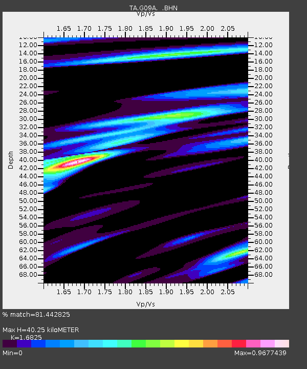
G09A Cove, OR, USA - Earthquake Result Viewer

Earthquake location: Bonin Islands, Japan Region
Earthquake latitude/longitude: 26.8/142.4
Earthquake time(UTC): 2008/02/27 (058) 06:54:20 GMT
Earthquake Depth: 15 km
Earthquake Magnitude: 5.8 MB, 6.1 MS, 6.2 MW, 6.2 MW
Earthquake Catalog/Contributor: WHDF/NEIC
Network: TA USArray Transportable Network (new EarthScope stations)
Station: G09A Cove, OR, USA
Lat/Lon: 45.28 N/117.78 W
Elevation: 1027 m
Distance: 77.8 deg
Az: 45.377 deg
Baz: 295.726 deg
Ray Param: 0.05003638
Estimated Moho Depth: 40.25 km
Estimated Crust Vp/Vs: 1.68
Assumed Crust Vp: 6.571 km/s
Estimated Crust Vs: 3.905 km/s
Estimated Crust Poisson's Ratio: 0.23
Radial Match: 81.442825 %
Radial Bump: 400
Transverse Match: 73.39125 %
Transverse Bump: 400
SOD ConfigId: 2564
Insert Time: 2010-03-07 01:34:19.434 +0000
GWidth: 2.5
Max Bumps: 400
Tol: 0.001

Signal To Noise

ChannelStoNSTALTA
TA:G09A: :BHN:20080227T07:05:46.024001Z0.60597561.6545812E-72.730442E-7
TA:G09A: :BHE:20080227T07:05:46.024001Z1.28448082.0081829E-71.56342E-7
TA:G09A: :BHZ:20080227T07:05:46.024001Z2.62879875.110416E-71.9440118E-7
Arrivals
Ps4.3 SECOND
PpPs16 SECOND
PsPs/PpSs20 SECOND