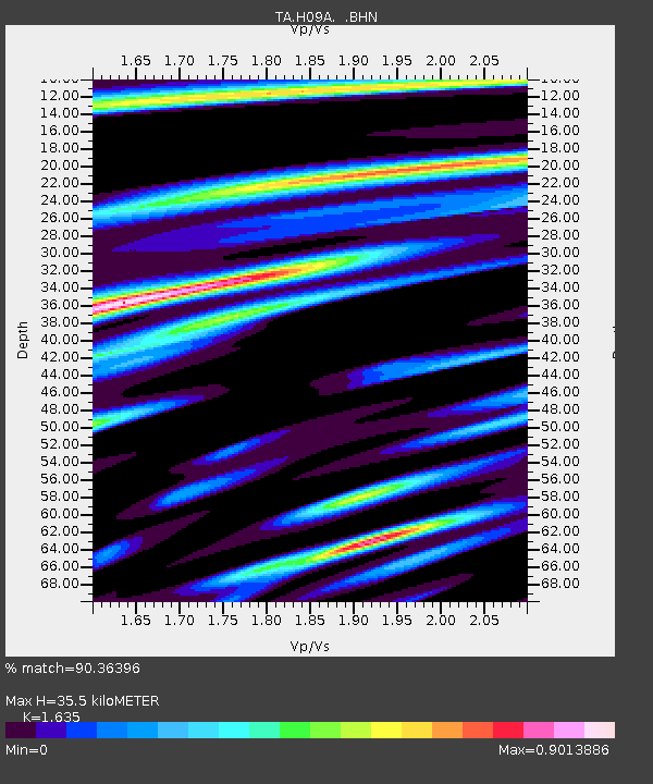
H09A Durkee, OR, USA - Earthquake Result Viewer

Earthquake location: Andreanof Islands, Aleutian Is.
Earthquake latitude/longitude: 51.4/-179.5
Earthquake time(UTC): 2007/12/19 (353) 09:30:27 GMT
Earthquake Depth: 29 km
Earthquake Magnitude: 6.4 MB, 7.1 MS, 7.1 MW, 7.0 MW
Earthquake Catalog/Contributor: WHDF/NEIC
Network: TA USArray Transportable Network (new EarthScope stations)
Station: H09A Durkee, OR, USA
Lat/Lon: 44.67 N/117.66 W
Elevation: 1263 m
Distance: 40.8 deg
Az: 74.288 deg
Baz: 302.247 deg
Ray Param: 0.0741223
Estimated Moho Depth: 35.5 km
Estimated Crust Vp/Vs: 1.63
Assumed Crust Vp: 6.571 km/s
Estimated Crust Vs: 4.019 km/s
Estimated Crust Poisson's Ratio: 0.20
Radial Match: 90.36396 %
Radial Bump: 400
Transverse Match: 80.744545 %
Transverse Bump: 400
SOD ConfigId: 2564
Insert Time: 2010-03-07 01:34:27.634 +0000
GWidth: 2.5
Max Bumps: 400
Tol: 0.001

Signal To Noise

ChannelStoNSTALTA
TA:H09A: :BHN:20071219T09:37:35.499014Z2.6543131.7056539E-66.4259706E-7
TA:H09A: :BHE:20071219T09:37:35.499014Z1.75134671.4082227E-68.040799E-7
TA:H09A: :BHZ:20071219T09:37:35.499014Z9.1029913.559521E-63.9102764E-7
Arrivals
Ps3.7 SECOND
PpPs13 SECOND
PsPs/PpSs17 SECOND