
Station TA H09A - Durkee, OR, USA
Network: TA - USArray Transportable Network (new EarthScope stations)
Nearby stations (2 deg radius)
| Station | Name | (Lat, Lon) | Start / End | Elevation |
| H09A | Durkee, OR, USA | (44.67, -117.66) | 2006-07-29 / 2499-01-01 | 1.3 km |
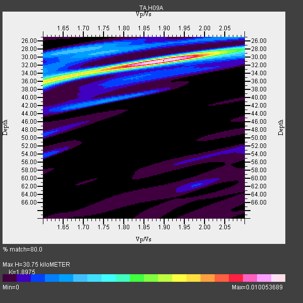
| Crust2 Type: | Q9,orogen/41km no ice, cordilleras, 0.25 km seds. |
| Thickness Estimate: | 31 km |
| Thickness StdDev: | 1.5 km |
| Vp/Vs Estimate: | 1.90 |
| Vp/Vs StdDev: | 0.08 |
| Vs Estimate: | 3.463 km/s |
| Poisson's Ratio: | 0.31 |
| Peak Value: | 0.01 |
| Assumed Vp: | 6.571 km/s |
| Ps Weight: | 0.33333334 |
| PpPs Weight: | 0.33333334 |
| PsPs Weight: | 0.33333328 |
| Residual Complexity: | 0.501 |
| Nearby stations H: | +- |
| (2.0 deg) Vp/Vs: | +- |
22 with match > 90% ( 41.509434 %) and 53 with match > 80% ( 100.0 %) out of 53.
Download stack as xyz text file.
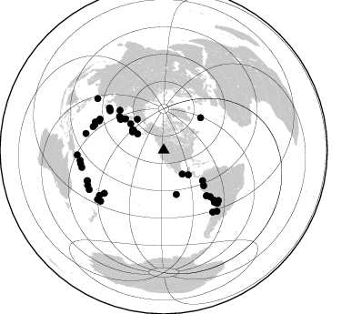
Azimuth Distribution of Events:
Prior Results for this Station
| Study | Thickness | Vp/Vs | Vp | Vs | Poissons Ratio | Extra |
| EARS | 31 km | 1.90 | 6.571 km/s | 3.463 km/s | 0.31 | |
| Crust2.0 | 41 km | 1.76 | 6.571 km/s | 3.735 km/s | 0.26 | Q9,orogen/41km no ice, cordilleras, 0.25 km seds. |
| Global Maxima | 31 km | 1.90 | 6.571 km/s | 3.463 km/s | 0.31 | amp=0.010053689 |
| Local Maxima 1 | 36 km | 1.62 | 6.571 km/s | 4.044 km/s | 0.20 | amp=0.006450491 |
| Local Maxima 2 | 28 km | 1.69 | 6.571 km/s | 3.894 km/s | 0.23 | amp=0.002985524 |
| Local Maxima 3 | 28 km | 2.10 | 6.571 km/s | 3.133 km/s | 0.35 | amp=0.0022181033 |
| Local Maxima 4 | 41 km | 1.75 | 6.571 km/s | 3.744 km/s | 0.26 | amp=0.0020188377 |
| Predicted Arrivals for vertical incidence (zero ray parameter) | |
| Ps | 4.20 SECOND |
| PpPs | 13.56 SECOND |
| PsPs/PpSs | 17.76 SECOND |
Events Processed for this Station
Download zip of receiver functions as SAC
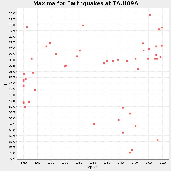
Plot maxima for each earthquake.
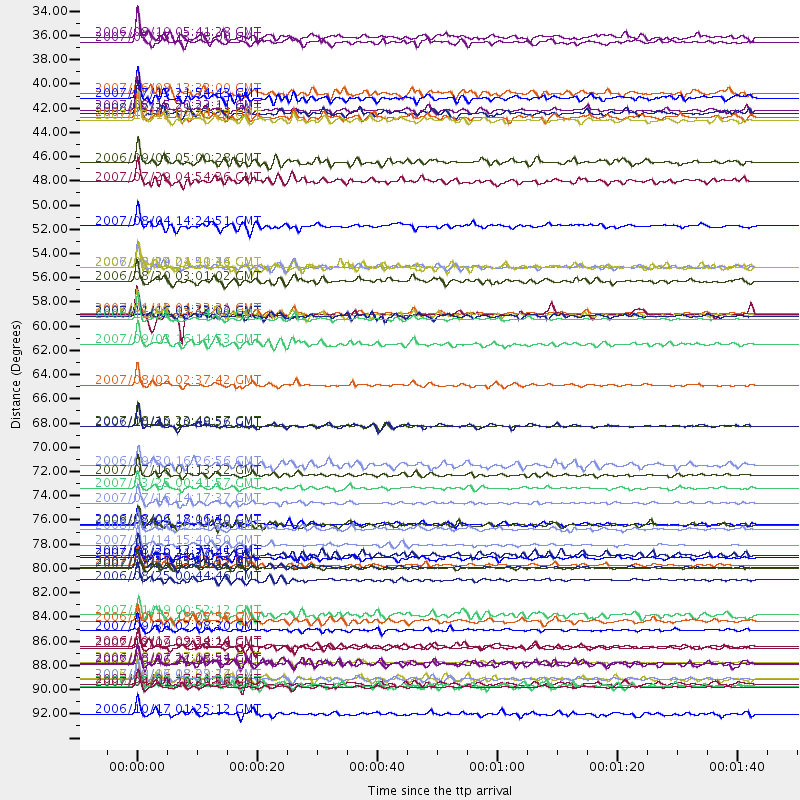
Events Used in the Stack
(53 events)| Radial Match | Distance | Baz | FERegion | Time | Lat/Lon | Depth | Magnitude |
| 97.88266 | 59.0 deg | 306.429 deg | Kuril Islands | 2006/11/15 11:14:13 GMT | (46.6, 153.3) | 10 km | 6.5 MB, 7.8 MS, 8.3 MW, 7.9 MW |
| 97.48689 | 92.5 deg | 260.715 deg | Solomon Islands | 2007/04/01 20:39:56 GMT | (-8.5, 157.0) | 10 km | 6.8 MB, 7.9 MS, 8.1 MW, 7.7 ME |
| 97.040245 | 79.6 deg | 135.773 deg | Northern Chile | 2007/11/14 15:40:50 GMT | (-22.2, -69.9) | 40 km | 6.7 MB, 7.4 MS, 7.7 MW, 7.4 ME |
| 96.96204 | 58.4 deg | 305.527 deg | East Of Kuril Islands | 2007/01/13 04:23:21 GMT | (46.2, 154.5) | 10 km | 7.3 MB, 8.2 MS, 8.1 MW, 7.9 MW |
| 96.47036 | 68.7 deg | 136.694 deg | Near Coast Of Peru | 2007/08/15 23:40:57 GMT | (-13.4, -76.6) | 39 km | 6.7 MB, 7.9 MS, 8.0 MW, 7.5 ME |
| 95.19327 | 54.2 deg | 128.171 deg | Near West Coast Of Colombia | 2007/09/10 01:49:14 GMT | (3.0, -78.0) | 31 km | 6.1 MB, 6.7 MS, 6.8 MW |
| 94.49597 | 91.8 deg | 258.062 deg | Solomon Islands | 2007/08/16 08:39:27 GMT | (-9.8, 159.5) | 10 km | 6.1 MB, 6.7 MS, 6.4 MW |
| 94.41143 | 90.3 deg | 248.328 deg | Vanuatu Islands | 2007/08/01 17:08:51 GMT | (-15.6, 167.7) | 120 km | 6.2 MB, 7.2 MW, 7.2 MW |
| 94.21905 | 58.6 deg | 306.487 deg | Kuril Islands | 2006/11/15 11:33:23 GMT | (46.9, 153.7) | 10 km | 5.5 MB |
| 93.864334 | 81.4 deg | 292.3 deg | Volcano Islands, Japan Region | 2007/09/28 13:38:59 GMT | (22.0, 142.7) | 276 km | 6.7 MB, 7.4 MW, 7.4 MW |
| 93.566414 | 73.2 deg | 306.287 deg | Near West Coast Of Honshu, Japan | 2007/07/16 01:13:22 GMT | (37.5, 138.4) | 12 km | 6.5 MB, 6.4 MS, 6.6 MW, 6.5 MW |
| 93.504326 | 82.8 deg | 134.732 deg | Chile-Argentina Border Region | 2006/08/25 00:44:46 GMT | (-24.4, -67.0) | 184 km | 5.9 MB, 6.6 MW, 6.6 MW |
| 93.337685 | 89.0 deg | 231.108 deg | South Of Fiji Islands | 2007/12/09 07:28:20 GMT | (-26.0, -177.5) | 152 km | 7.0 MB, 7.8 MW, 7.7 MW |
| 93.17147 | 87.4 deg | 282.021 deg | South Of Mariana Islands | 2007/09/30 02:08:30 GMT | (10.5, 145.7) | 14 km | 6.4 MB, 7.1 MS, 6.9 MW, 6.9 MW |
| 92.97599 | 65.0 deg | 312.196 deg | Sakhalin, Russia | 2007/08/02 02:37:42 GMT | (47.1, 141.8) | 5.0 km | 6.2 MS, 5.3 MB, 6.2 MW, 6.2 MW |
| 92.638885 | 75.8 deg | 307.84 deg | Sea Of Japan | 2007/07/16 14:17:37 GMT | (36.8, 134.9) | 350 km | 6.2 MB, 6.8 MW, 6.8 MW |
| 92.61847 | 61.2 deg | 307.17 deg | Kuril Islands | 2007/09/03 16:14:53 GMT | (45.8, 150.1) | 94 km | 6.3 MB, 6.2 MW, 6.2 ME |
| 92.4108 | 68.8 deg | 136.799 deg | Near Coast Of Peru | 2006/10/20 10:48:56 GMT | (-13.5, -76.7) | 23 km | 5.9 MB, 6.6 MS, 6.7 MW, 6.6 MW |
| 92.324684 | 81.7 deg | 288.269 deg | Mariana Islands | 2007/10/31 03:30:17 GMT | (18.9, 145.4) | 223 km | 6.2 MB, 7.2 MW, 7.2 MW |
| 91.591446 | 54.2 deg | 309.351 deg | Near East Coast Of Kamchatka | 2006/08/24 21:50:36 GMT | (51.1, 157.5) | 43 km | 5.9 MB, 6.2 MS, 6.5 MW, 6.5 MW |
| 91.19535 | 33.6 deg | 301.729 deg | Fox Islands, Aleutian Islands | 2007/07/15 13:08:00 GMT | (52.5, -168.0) | 10 km | 5.8 MB, 5.9 MS, 6.1 MW, 6.0 MW |
| 90.36396 | 40.8 deg | 302.247 deg | Andreanof Islands, Aleutian Is. | 2007/12/19 09:30:27 GMT | (51.4, -179.5) | 29 km | 6.4 MB, 7.1 MS, 7.1 MW, 7.0 MW |
| 89.66266 | 81.6 deg | 132.499 deg | Jujuy Province, Argentina | 2007/07/21 15:34:52 GMT | (-22.2, -65.8) | 290 km | 5.8 MB, 6.4 MW, 6.3 MW |
| 89.51497 | 38.7 deg | 302.177 deg | Andreanof Islands, Aleutian Is. | 2007/07/13 21:54:43 GMT | (51.8, -176.3) | 35 km | 5.7 MB, 5.6 MS, 6.0 MW, 5.9 MW |
| 88.71092 | 92.3 deg | 307.849 deg | Taiwan Region | 2007/09/06 17:51:26 GMT | (24.3, 122.2) | 53 km | 6.1 MB, 6.2 MW, 6.1 ME |
| 88.62234 | 39.9 deg | 300.173 deg | Andreanof Islands, Aleutian Is. | 2007/08/15 20:22:11 GMT | (50.3, -177.5) | 9.0 km | 6.3 MB, 6.2 MS, 6.4 MW, 5.9 ML |
| 88.570274 | 58.6 deg | 305.501 deg | East Of Kuril Islands | 2006/12/07 19:10:21 GMT | (46.2, 154.4) | 16 km | 6.3 MB, 6.1 MS, 6.3 MW, 6.3 MW |
| 88.38922 | 38.3 deg | 134.861 deg | Near Coast Of Guatemala | 2007/06/08 13:32:00 GMT | (13.8, -90.8) | 48 km | 5.5 MB, 5.4 MS, 5.8 MW, 5.8 MW |
| 88.024185 | 80.5 deg | 233.965 deg | Tonga Islands | 2007/08/26 12:37:31 GMT | (-17.5, -174.3) | 127 km | 5.9 MB, 6.1 MW |
| 87.72344 | 74.4 deg | 307.21 deg | Near West Coast Of Honshu, Japan | 2007/03/25 00:41:57 GMT | (37.3, 136.6) | 8.0 km | 6.1 MB, 6.8 MS, 6.7 MW, 6.6 MW |
| 87.20602 | 90.4 deg | 248.12 deg | Vanuatu Islands | 2006/08/07 22:18:54 GMT | (-15.8, 167.8) | 141 km | 6.0 MB, 6.8 MW, 6.8 MW |
| 86.57911 | 58.7 deg | 131.501 deg | Peru-Ecuador Border Region | 2007/11/16 03:13:00 GMT | (-2.3, -77.8) | 123 km | 6.3 MB, 6.8 MW, 6.7 MW |
| 86.47529 | 77.7 deg | 294.408 deg | Bonin Islands, Japan Region | 2006/08/06 18:16:40 GMT | (26.1, 144.0) | 23 km | 6.0 MB, 5.6 MS, 5.8 MW, 5.8 MW |
| 86.30108 | 95.1 deg | 266.768 deg | New Britain Region, P.N.G. | 2006/10/17 01:25:12 GMT | (-5.9, 151.0) | 32 km | 6.4 MB, 6.9 MS, 6.7 MW, 6.6 MW |
| 85.585106 | 77.8 deg | 134.754 deg | Near Coast Of Northern Chile | 2008/02/04 17:01:30 GMT | (-20.2, -70.0) | 44 km | 6.0 MB, 6.2 MS, 6.3 MW, 6.3 MW |
| 85.292915 | 44.7 deg | 319.301 deg | Eastern Siberia, Russia | 2006/09/06 05:00:28 GMT | (61.6, 168.6) | 10 km | 5.5 MB, 5.0 MS, 5.4 MW, 5.3 MW |
| 84.41616 | 46.4 deg | 308.299 deg | Komandorskiye Ostrova Region | 2007/07/29 04:54:36 GMT | (53.6, 169.7) | 26 km | 6.0 MB, 5.5 MS, 5.9 MW, 5.8 MW |
| 84.40518 | 90.5 deg | 233.323 deg | South Of Fiji Islands | 2007/10/16 21:05:43 GMT | (-25.8, 179.5) | 509 km | 6.2 MB, 6.6 MW, 6.5 MW |
| 83.57028 | 50.5 deg | 164.074 deg | Central East Pacific Rise | 2007/08/04 14:24:51 GMT | (-4.8, -105.4) | 10 km | 5.7 MS, 5.4 MB, 6.0 MW, 5.9 MW |
| 83.50076 | 54.2 deg | 48.964 deg | Northern Mid-Atlantic Ridge | 2007/05/23 04:41:46 GMT | (52.4, -31.8) | 10 km | 5.6 MS, 5.4 MB, 5.7 MW, 5.6 MW |
| 83.411545 | 55.5 deg | 308.365 deg | Kuril Islands | 2006/08/20 03:01:02 GMT | (49.8, 156.4) | 26 km | 5.8 MB, 5.7 MS, 6.0 MW, 5.9 MW |
| 83.332466 | 72.3 deg | 134.853 deg | Southern Peru | 2006/09/30 16:26:56 GMT | (-15.6, -73.2) | 107 km | 5.6 MB, 6.0 MW, 5.9 MW |
| 83.32517 | 78.2 deg | 295.917 deg | Bonin Islands, Japan Region | 2008/02/27 06:54:20 GMT | (26.8, 142.4) | 15 km | 5.8 MB, 6.1 MS, 6.2 MW, 6.2 MW |
| 83.19891 | 92.4 deg | 262.987 deg | Solomon Islands | 2006/09/01 10:18:51 GMT | (-6.8, 155.5) | 38 km | 6.3 MB, 6.7 MS, 6.8 MW, 6.7 MW |
| 82.89693 | 40.5 deg | 302.1 deg | Andreanof Islands, Aleutian Is. | 2007/12/21 07:24:34 GMT | (51.4, -179.0) | 30 km | 6.1 MB, 6.2 MW, 6.3 ML |
| 82.40421 | 80.7 deg | 290.218 deg | Mariana Islands | 2007/01/30 21:37:45 GMT | (21.0, 144.7) | 30 km | 6.3 MB, 6.5 MS, 6.6 MW, 6.5 MW |
| 81.99416 | 40.1 deg | 303.259 deg | Andreanof Islands, Aleutian Is. | 2008/03/22 21:24:11 GMT | (52.2, -178.7) | 132 km | 5.8 MB, 6.2 MW, 6.1 MW |
| 81.97196 | 88.9 deg | 138.896 deg | San Juan Province, Argentina | 2006/09/17 09:34:14 GMT | (-31.7, -67.2) | 142 km | 5.7 MB, 6.2 MW, 6.2 MW |
| 81.49359 | 86.6 deg | 141.661 deg | Near Coast Of Central Chile | 2006/10/12 18:05:58 GMT | (-31.3, -71.3) | 46 km | 5.8 MB, 6.1 MS, 6.4 MW, 6.3 MW |
| 81.220604 | 92.5 deg | 242.086 deg | Southeast Of Loyalty Islands | 2007/07/27 14:46:26 GMT | (-21.5, 170.9) | 10 km | 6.0 MB, 6.0 MS, 6.1 MW, 6.1 MW |
| 81.008156 | 91.8 deg | 245.174 deg | Vanuatu Islands | 2006/10/03 18:03:14 GMT | (-18.9, 169.0) | 171 km | 5.9 MB, 6.3 MW, 6.3 MW |
| 80.77519 | 33.2 deg | 142.245 deg | Oaxaca, Mexico | 2006/08/19 05:41:28 GMT | (16.2, -97.3) | 32 km | 5.1 MB, 5.1 MS, 5.6 MW, 5.6 MW |
| 80.64554 | 86.0 deg | 234.979 deg | Fiji Islands Region | 2007/11/19 00:52:12 GMT | (-21.2, -178.8) | 558 km | 6.2 MB, 6.3 MW, 6.3 MW |
Losers
(0 events)| Radial Match | Distance | Baz | FERegion | Time | Lat/Lon | Depth | Magnitude | Reason |
