You are here: Home > Network List > TA - USArray Transportable Network (new EarthScope stations) Stations List
> Station H09A Durkee, OR, USA > Earthquake Result Viewer
H09A Durkee, OR, USA - Earthquake Result Viewer
| Earthquake location: |
Fiji Islands Region |
| Earthquake latitude/longitude: |
-21.2/-178.8 |
| Earthquake time(UTC): |
2007/11/19 (323) 00:52:12 GMT |
| Earthquake Depth: |
558 km |
| Earthquake Magnitude: |
6.2 MB, 6.3 MW, 6.3 MW |
| Earthquake Catalog/Contributor: |
WHDF/NEIC |
|
| Network: |
TA USArray Transportable Network (new EarthScope stations) |
| Station: |
H09A Durkee, OR, USA |
| Lat/Lon: |
44.67 N/117.66 W |
| Elevation: |
1263 m |
|
| Distance: |
86.0 deg |
| Az: |
38.77 deg |
| Baz: |
234.979 deg |
| Ray Param: |
0.042793266 |
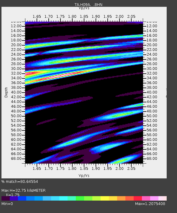
| Estimated Moho Depth: |
32.75 km |
| Estimated Crust Vp/Vs: |
1.75 |
| Assumed Crust Vp: |
6.571 km/s |
| Estimated Crust Vs: |
3.755 km/s |
| Estimated Crust Poisson's Ratio: |
0.26 |
|
| Radial Match: |
80.64554 % |
| Radial Bump: |
400 |
| Transverse Match: |
67.688805 % |
| Transverse Bump: |
400 |
| SOD ConfigId: |
2564 |
| Insert Time: |
2010-03-07 01:34:32.110 +0000 |
| GWidth: |
2.5 |
| Max Bumps: |
400 |
| Tol: |
0.001 |
|

Signal To Noise
| Channel | StoN | STA | LTA |
| TA:H09A: :BHN:20071119T01:03:22.749014Z | 1.6788943 | 5.197764E-7 | 3.095945E-7 |
| TA:H09A: :BHE:20071119T01:03:22.749014Z | 6.0311913 | 1.1882443E-6 | 1.970165E-7 |
| TA:H09A: :BHZ:20071119T01:03:22.749014Z | 9.0305195 | 3.3526978E-6 | 3.7126304E-7 |
| Arrivals |
| Ps | 3.8 SECOND |
| PpPs | 13 SECOND |
| PsPs/PpSs | 17 SECOND |


