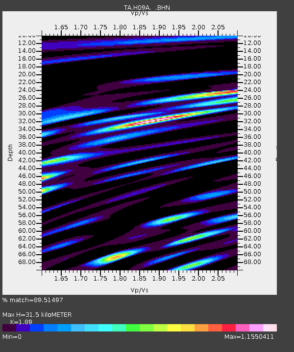
H09A Durkee, OR, USA - Earthquake Result Viewer
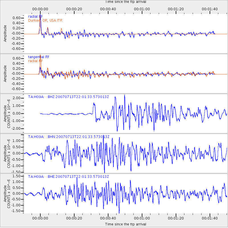
Earthquake location: Andreanof Islands, Aleutian Is.
Earthquake latitude/longitude: 51.8/-176.3
Earthquake time(UTC): 2007/07/13 (194) 21:54:43 GMT
Earthquake Depth: 35 km
Earthquake Magnitude: 5.7 MB, 5.6 MS, 6.0 MW, 5.9 MW
Earthquake Catalog/Contributor: WHDF/NEIC
Network: TA USArray Transportable Network (new EarthScope stations)
Station: H09A Durkee, OR, USA
Lat/Lon: 44.67 N/117.66 W
Elevation: 1263 m
Distance: 38.7 deg
Az: 76.769 deg
Baz: 302.177 deg
Ray Param: 0.075317666
Estimated Moho Depth: 31.5 km
Estimated Crust Vp/Vs: 1.89
Assumed Crust Vp: 6.571 km/s
Estimated Crust Vs: 3.477 km/s
Estimated Crust Poisson's Ratio: 0.31
Radial Match: 89.51497 %
Radial Bump: 400
Transverse Match: 78.61507 %
Transverse Bump: 400
SOD ConfigId: 2564
Insert Time: 2010-03-07 01:35:20.920 +0000
GWidth: 2.5
Max Bumps: 400
Tol: 0.001

Signal To Noise

ChannelStoNSTALTA
TA:H09A: :BHN:20070713T22:01:33.573013Z6.7397743.2327952E-74.796593E-8
TA:H09A: :BHE:20070713T22:01:33.573013Z4.64945172.928069E-76.297665E-8
TA:H09A: :BHZ:20070713T22:01:33.573013Z17.2829937.2568355E-74.19883E-8
Arrivals
Ps4.6 SECOND
PpPs13 SECOND
PsPs/PpSs17 SECOND