You are here: Home > Network List > TA - USArray Transportable Network (new EarthScope stations) Stations List
> Station H09A Durkee, OR, USA > Earthquake Result Viewer
H09A Durkee, OR, USA - Earthquake Result Viewer
| Earthquake location: |
Near Coast Of Guatemala |
| Earthquake latitude/longitude: |
13.8/-90.8 |
| Earthquake time(UTC): |
2007/06/08 (159) 13:32:00 GMT |
| Earthquake Depth: |
48 km |
| Earthquake Magnitude: |
5.5 MB, 5.4 MS, 5.8 MW, 5.8 MW |
| Earthquake Catalog/Contributor: |
WHDF/NEIC |
|
| Network: |
TA USArray Transportable Network (new EarthScope stations) |
| Station: |
H09A Durkee, OR, USA |
| Lat/Lon: |
44.67 N/117.66 W |
| Elevation: |
1263 m |
|
| Distance: |
38.3 deg |
| Az: |
328.62 deg |
| Baz: |
134.861 deg |
| Ray Param: |
0.075511836 |
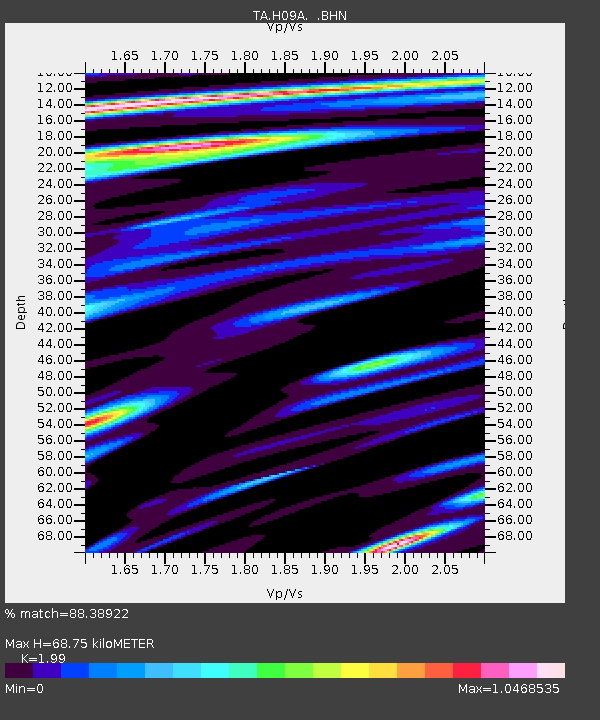
| Estimated Moho Depth: |
68.75 km |
| Estimated Crust Vp/Vs: |
1.99 |
| Assumed Crust Vp: |
6.571 km/s |
| Estimated Crust Vs: |
3.302 km/s |
| Estimated Crust Poisson's Ratio: |
0.33 |
|
| Radial Match: |
88.38922 % |
| Radial Bump: |
400 |
| Transverse Match: |
74.90539 % |
| Transverse Bump: |
400 |
| SOD ConfigId: |
2564 |
| Insert Time: |
2010-03-07 01:35:23.353 +0000 |
| GWidth: |
2.5 |
| Max Bumps: |
400 |
| Tol: |
0.001 |
|
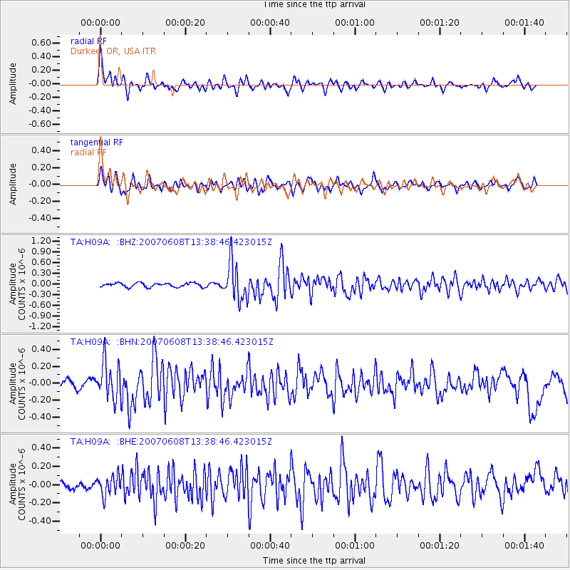
Signal To Noise
| Channel | StoN | STA | LTA |
| TA:H09A: :BHN:20070608T13:38:46.423015Z | 3.3616536 | 2.2141482E-7 | 6.586485E-8 |
| TA:H09A: :BHE:20070608T13:38:46.423015Z | 2.322111 | 1.0751228E-7 | 4.6299373E-8 |
| TA:H09A: :BHZ:20070608T13:38:46.423015Z | 9.691379 | 5.412707E-7 | 5.5850744E-8 |
| Arrivals |
| Ps | 11 SECOND |
| PpPs | 29 SECOND |
| PsPs/PpSs | 40 SECOND |


