You are here: Home > Network List > TA - USArray Transportable Network (new EarthScope stations) Stations List
> Station H09A Durkee, OR, USA > Earthquake Result Viewer
H09A Durkee, OR, USA - Earthquake Result Viewer
| Earthquake location: |
Kuril Islands |
| Earthquake latitude/longitude: |
46.9/153.7 |
| Earthquake time(UTC): |
2006/11/15 (319) 11:33:23 GMT |
| Earthquake Depth: |
10 km |
| Earthquake Magnitude: |
5.5 MB |
| Earthquake Catalog/Contributor: |
WHDF/NEIC |
|
| Network: |
TA USArray Transportable Network (new EarthScope stations) |
| Station: |
H09A Durkee, OR, USA |
| Lat/Lon: |
44.67 N/117.66 W |
| Elevation: |
1263 m |
|
| Distance: |
58.6 deg |
| Az: |
56.728 deg |
| Baz: |
306.487 deg |
| Ray Param: |
0.06276154 |
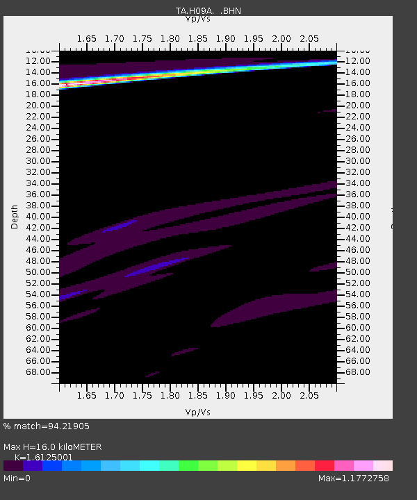
| Estimated Moho Depth: |
16.0 km |
| Estimated Crust Vp/Vs: |
1.61 |
| Assumed Crust Vp: |
6.571 km/s |
| Estimated Crust Vs: |
4.075 km/s |
| Estimated Crust Poisson's Ratio: |
0.19 |
|
| Radial Match: |
94.21905 % |
| Radial Bump: |
400 |
| Transverse Match: |
83.73917 % |
| Transverse Bump: |
400 |
| SOD ConfigId: |
2564 |
| Insert Time: |
2010-03-07 01:35:39.122 +0000 |
| GWidth: |
2.5 |
| Max Bumps: |
400 |
| Tol: |
0.001 |
|
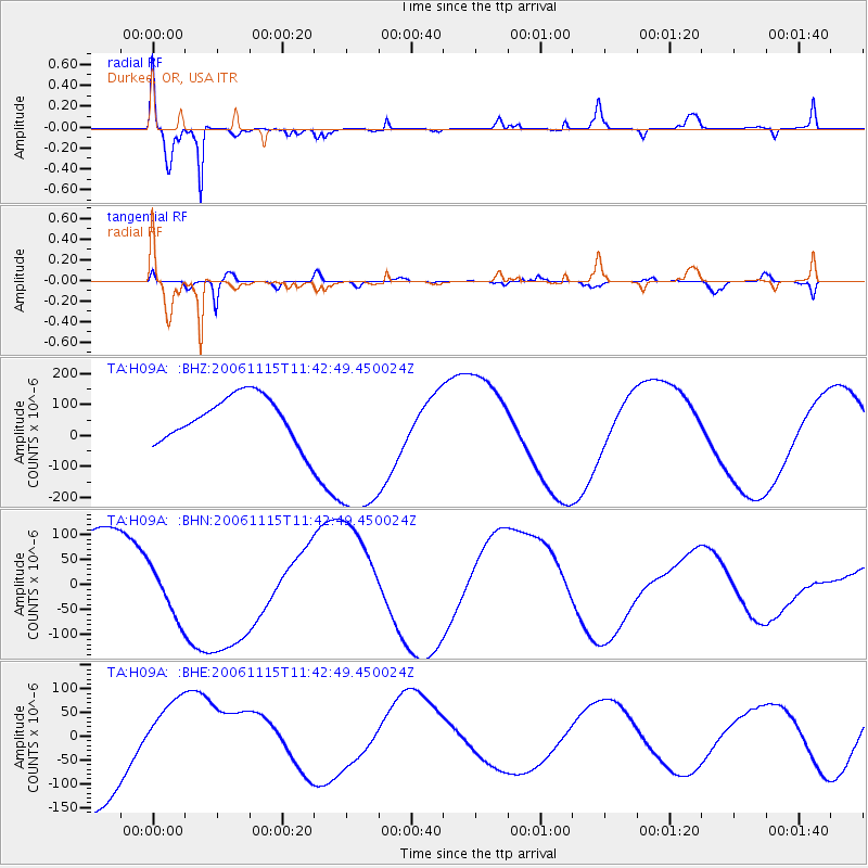
Signal To Noise
| Channel | StoN | STA | LTA |
| TA:H09A: :BHN:20061115T11:42:49.450024Z | 0.8123506 | 5.771006E-5 | 7.1040835E-5 |
| TA:H09A: :BHE:20061115T11:42:49.450024Z | 0.7757133 | 7.6030876E-5 | 9.8014134E-5 |
| TA:H09A: :BHZ:20061115T11:42:49.450024Z | 3.8654795 | 2.8163238E-4 | 7.285833E-5 |
| Arrivals |
| Ps | 1.6 SECOND |
| PpPs | 6.0 SECOND |
| PsPs/PpSs | 7.6 SECOND |


