You are here: Home > Network List > TA - USArray Transportable Network (new EarthScope stations) Stations List
> Station H09A Durkee, OR, USA > Earthquake Result Viewer
H09A Durkee, OR, USA - Earthquake Result Viewer
| Earthquake location: |
Oaxaca, Mexico |
| Earthquake latitude/longitude: |
16.2/-97.3 |
| Earthquake time(UTC): |
2006/08/19 (231) 05:41:28 GMT |
| Earthquake Depth: |
32 km |
| Earthquake Magnitude: |
5.1 MB, 5.1 MS, 5.6 MW, 5.6 MW |
| Earthquake Catalog/Contributor: |
WHDF/NEIC |
|
| Network: |
TA USArray Transportable Network (new EarthScope stations) |
| Station: |
H09A Durkee, OR, USA |
| Lat/Lon: |
44.67 N/117.66 W |
| Elevation: |
1263 m |
|
| Distance: |
33.2 deg |
| Az: |
332.947 deg |
| Baz: |
142.245 deg |
| Ray Param: |
0.0782811 |
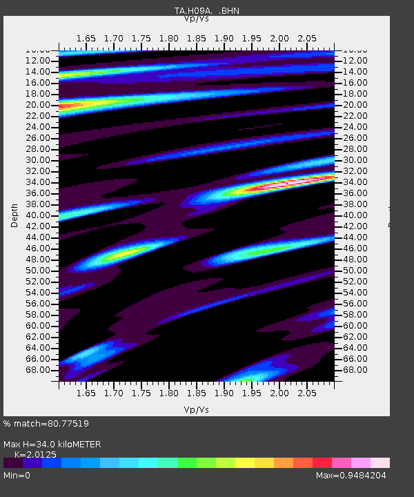
| Estimated Moho Depth: |
34.0 km |
| Estimated Crust Vp/Vs: |
2.01 |
| Assumed Crust Vp: |
6.571 km/s |
| Estimated Crust Vs: |
3.265 km/s |
| Estimated Crust Poisson's Ratio: |
0.34 |
|
| Radial Match: |
80.77519 % |
| Radial Bump: |
400 |
| Transverse Match: |
77.49532 % |
| Transverse Bump: |
400 |
| SOD ConfigId: |
2564 |
| Insert Time: |
2010-03-07 01:35:49.904 +0000 |
| GWidth: |
2.5 |
| Max Bumps: |
400 |
| Tol: |
0.001 |
|

Signal To Noise
| Channel | StoN | STA | LTA |
| TA:H09A: :BHN:20060819T05:47:31.64801Z | 3.7672024 | 2.1010818E-7 | 5.5773E-8 |
| TA:H09A: :BHE:20060819T05:47:31.64801Z | 1.2619066 | 6.599948E-8 | 5.23014E-8 |
| TA:H09A: :BHZ:20060819T05:47:31.64801Z | 5.9087224 | 3.8328562E-7 | 6.486776E-8 |
| Arrivals |
| Ps | 5.6 SECOND |
| PpPs | 15 SECOND |
| PsPs/PpSs | 20 SECOND |


